Drone Survey Services in Katy, TX
From Cane Island and Elyson to the Energy Corridor and the Grand Parkway expansion, Katy is one of Houston's fastest-growing west-side submarkets where master-planned communities and commercial development drive continuous survey demand.
Serving Harris County & the Houston-The Woodlands-Sugar Land area
Request a Free Quote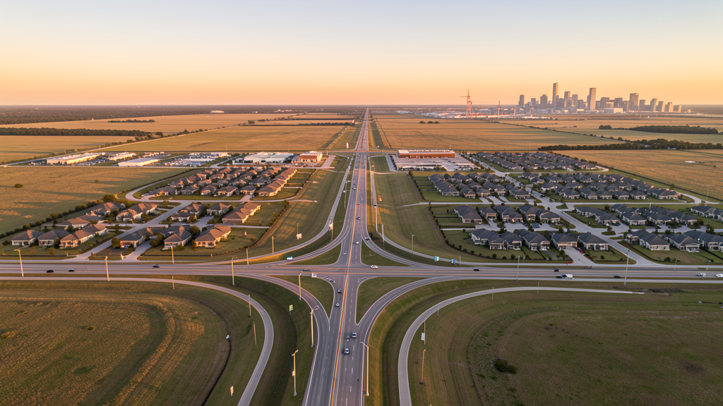
Get Matched With a Local Surveyor
Drone Survey Services Available in Katy, TX
The Houston-The Woodlands-Sugar Land metro is the largest or second-largest construction market in the US, and the greater Katy area is one of its highest-growth submarkets. Straddling Harris, Fort Bend, and Waller Counties along I-10, Katy is driven by massive master-planned communities (Cane Island, Elyson, Cinco Ranch, Marvida), the Energy Corridor office market, and the Grand Parkway expansion. The greater Katy area exceeds 300,000 residents despite the city proper being only 27,000. For drone surveyors, this means high-volume residential construction demand with moderate airspace complexity.
Drone Surveys for Katy's Construction Market
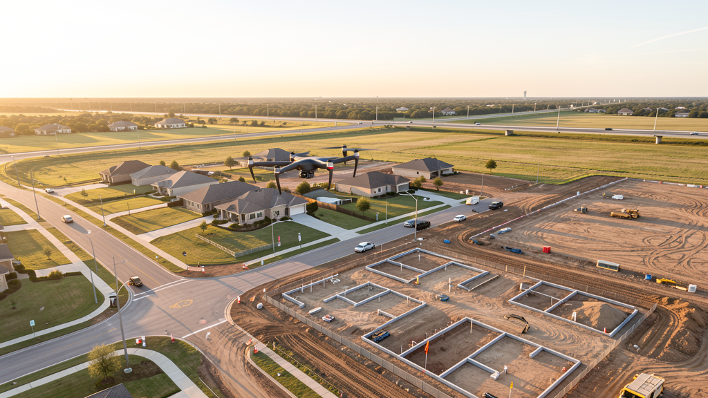
Katy is one of the fastest-growing communities in the Houston metro, straddling three counties (Harris, Fort Bend, Waller) along the I-10 west corridor. The city itself is small (27,000) but the greater Katy area exceeds 300,000 residents. Master-planned communities are the primary growth engine: Cane Island (Johnson Development, 1,100 acres), Elyson (Johnson Development, 3,600 acres), and Cinco Ranch (one of the largest MPCs in the US at build-out) drive continuous residential construction. The Grand Parkway (TX-99) has opened new development corridors north and south of I-10, connecting Katy to the broader Houston metro. The Energy Corridor office market east of Katy continues to see corporate campus development and renovation. Commercial development along the I-10 corridor, including Katy Mills Mall expansion and the Boardwalk District mixed-use project, adds retail and hospitality construction. The Texas Department of Transportation's ongoing I-10 improvement projects generate heavy civil survey demand.
Active Developers in the Area:
Typical Project Costs in Texas
Cost ranges are based on market data for Houston-The Woodlands-Sugar Land. Actual pricing depends on site size, complexity, and deliverables.
| Service Type | Low End | High End |
|---|---|---|
| Topographic Survey | $1,500 | $4,500 |
| Drone Inspection | $225 | $800 |
| LiDAR Scanning | $2,500 | $8,500 |
| Environmental Monitoring | $800 | $3,500 |
| Aerial Imagery | $175 | $500 |
| Construction Monitoring | $900 | $3,000 |
| Real Estate Photography | $150 | $450 |
| Roof Inspection | $200 | $750 |
Local Airspace & Regulations in Katy, TX
FAA Part 107 Requirements
All commercial drone operations in Texas require the pilot to hold an active FAA Part 107 Remote Pilot Certificate. Our network surveyors are verified Part 107 holders.
State Drone Laws
Texas Government Code Chapter 423 restricts drone use over critical infrastructure facilities, including oil and gas pipelines, refineries, power plants, and water treatment facilities. HB 1484 (2023) added protections for agricultural operations and expanded penalties for drone surveillance of private property. Commercial operators must hold a valid FAA Part 107 Remote Pilot Certificate. Texas does not require a separate state drone license, but operators flying near critical infrastructure must obtain authorization from the facility owner. The Texas Department of Public Safety maintains additional guidelines for drone operations near state facilities.
Local Ordinances
The City of Katy does not issue a separate city-level drone permit for commercial operators. FAA Part 107 certification and LAANC authorization for Class D (SGR) and Class C (HOU) airspace are the primary requirements. Commercial filming on city property requires a permit through the Katy Parks and Recreation Department. The city prohibits drone takeoff and landing in city parks without a special use permit, including Katy City Park and Mary Jo Peckham Park. Flights from private property (with owner permission) do not require a city permit but must comply with all FAA Part 107 rules and Texas Government Code Chapter 423 critical infrastructure restrictions. The Energy Corridor east of Katy contains multiple critical infrastructure facilities where unauthorized drone flights are a state misdemeanor.
Restricted Airspace
- Class D airspace around Sugar Land Regional Airport (SGR) — located 12 miles south. The northern edge of SGR Class D extends into southern Katy. Drone flights within 4 nautical miles require LAANC authorization. This affects survey work in south Katy along FM 1093 and Westpark Tollway.
- Class B airspace around IAH — the outer southwestern shelves of IAH Class B may extend into the far northeast corner of the Katy area. Most of Katy proper falls outside controlled airspace, making LAANC unnecessary for the majority of residential and commercial survey work in central and western Katy.
- Class C airspace around Hobby Airport (HOU) — located 25 miles southeast. The outer western shelves of HOU Class C extend into southeast Katy. Verify altitude shelves on FAA UAS Facility Maps for survey work near the Westpark Tollway and I-10 interchange.
- Energy Corridor critical infrastructure — the Energy Corridor along I-10 east of Katy contains major oil and gas company headquarters (BP, ExxonMobil, ConocoPhillips, Shell) and associated facilities. Under TX Government Code Chapter 423, drone flights over these critical infrastructure facilities without authorization are a state misdemeanor. The corridor has active security monitoring.
- Katy Mills and commercial district — while not formal restricted airspace, the density of retail and commercial development around Katy Mills Mall and the I-10/Grand Parkway interchange means drone pilots should coordinate with property management for any survey work in the area.
- Hurricane and tropical weather: Katy is in a high-risk hurricane and flood zone, having experienced significant flooding during Hurricane Harvey in 2017. The Barker Reservoir and Addicks Reservoir watersheds affect eastern Katy. Drone operations during tropical storm warnings are restricted. Post-storm assessment flights require coordination with Harris County Office of Emergency Management. Summer thunderstorms and high humidity affect flight windows — morning flights are strongly preferred May through September.
Airports in the area: undefined (undefined), undefined (undefined), undefined (undefined), undefined (undefined)
Why Hire Through Aerius View in Katy, TX?
FAA-Certified
Every surveyor holds an active Part 107 Remote Pilot Certificate.
Local to Katy
Surveyors who know the Texas airspace and local permitting.
No Cost to Quote
Submit your project at no charge. Pay the surveyor directly if you proceed.
Fast Turnaround
A local surveyor contacts you within 2 business days.
How Our Katy Matching Process Works
We're actively building our network of FAA-certified drone operators in Katy, TX. Here's exactly what happens when you submit a project request.
Submit Your Project
Tell us your site location, acreage, and what you need (topographic survey, LiDAR, inspection, etc.). Takes 60 seconds. No cost, no obligation.
We Match & Vet
We identify Part 107-certified operators in Texas with the right equipment for your project. Every pilot is verified for active certification, insurance, and relevant experience in Texas airspace.
You Get Quotes
Matched surveyors contact you within 2 business days with quotes. You compare pricing, timelines, and deliverables, then choose the right fit. You pay the surveyor directly, no markup.
What Deliverables Do You Get?
Every project includes professional-grade deliverables compatible with standard construction and engineering software:
- Orthomosaic maps (GeoTIFF) for site overview and documentation
- Point clouds (LAS/LAZ) for 3D modeling and volumetric analysis
- DEM/DSM terrain models for cut/fill and grade analysis
- Contour lines (DXF/DWG, CAD-ready) for Civil 3D and Revit
- Progress reports with side-by-side comparisons for construction monitoring
- Coordinate systems matched to your project datum (State Plane, UTM, or local)
Insurance & Liability Protection
Pilot Insurance Required
Every operator in our network must carry active liability insurance. Minimum coverage: $1,000,000 general liability. Proof of insurance is verified before any pilot joins the network.
FAA Part 107 Verified
We confirm each pilot's Remote Pilot Certificate is active and in good standing through the FAA Airmen Inquiry system. Expired certificates are flagged automatically.
Equipment Documentation
Pilots list their drone models, sensors (RGB, LiDAR, thermal, multispectral), and payload specs so we can match the right equipment to your project requirements.
Site Safety Coordination
Pilots coordinate with your site superintendent for safe operations on active construction sites, including flight plans that avoid worker areas and equipment zones.
Katy, TX Drone Survey FAQs
Do I need a permit for a drone survey in Katy?
The City of Katy does not issue a separate drone permit for commercial operators. FAA Part 107 certification is mandatory. LAANC authorization is required for flights in south Katy within the Sugar Land Regional Airport (SGR) Class D zone, and in southeast Katy within the Hobby Airport (HOU) Class C shelves. Most of central and western Katy falls outside controlled airspace, making LAANC unnecessary for many residential survey jobs. Flights from private property with owner permission do not require a city permit.
How much does a drone survey cost in Katy?
Katy pricing is competitive with the broader Houston metro. Topographic surveys typically range from $1,500 to $4,500 for residential lots and commercial sites. LiDAR scanning runs $2,500 to $8,500 for larger MPC parcels like Cane Island or Elyson. Roof inspections cost $200 to $750 per building. Construction monitoring is typically $900 to $3,000 per month for recurring flights at master-planned community sites.
Can I fly a drone near the Energy Corridor in Katy?
The Energy Corridor along I-10 east of Katy contains major oil and gas company headquarters and facilities designated as critical infrastructure under Texas Government Code Chapter 423. Drone flights over these facilities without authorization are a state misdemeanor. The corridor has active security monitoring. For survey work near Energy Corridor facilities, coordinate with facility security in advance and maintain a safe distance. Flights over adjacent residential and commercial areas are permissible with Part 107 certification.
How does Hurricane Harvey history affect drone survey work in Katy?
Katy experienced significant flooding during Hurricane Harvey in 2017, particularly in areas near the Barker Reservoir watershed. Post-storm damage assessment flights require coordination with Harris County Office of Emergency Management. The flat terrain and extensive flood control infrastructure make accurate topographic data critical for drainage design and FEMA flood plain mapping. Our surveyors use RTK GPS for centimeter-level accuracy on flood plain certification surveys.
What are the main master-planned communities generating survey demand in Katy?
The greater Katy area has some of the largest MPCs in the Houston metro. Cane Island (Johnson Development, 1,100 acres), Elyson (Johnson Development, 3,600 acres), Cinco Ranch (one of the largest in the US at build-out), and Marvida (Newland Communities) all have continuous residential, commercial, and amenity construction. The Grand Parkway has opened new corridors north of I-10, creating additional greenfield development opportunities that require topographic surveys before site work begins.
What makes Katy unique for drone survey work?
Katy combines massive residential construction volume with relatively simple airspace for most of the area. The I-10 and Grand Parkway corridors provide excellent access to multiple active construction sites. The flat Gulf Coast terrain makes photogrammetry efficient, but the flood-prone nature of the area means accurate topographic data is critical for drainage design. The Energy Corridor proximity creates commercial and industrial survey demand alongside the residential MPC work, giving surveyors a diversified client base.
Nearby Cities
Are You a Drone Surveyor in Katy?
Get pre-qualified leads in your service area. No membership fees, no monthly minimums. First lead free.
Ready to Start Your Project in Katy, TX?
Get matched with a local, FAA-certified surveyor. No cost, no obligation.
Request a Free Quote