Drone Survey Services in Sugar Land, TX
From Fluor Corporation's global HQ and the Town Square district to Riverstone and Aliana, Sugar Land is Fort Bend County's premier corporate campus city where high-value survey contracts and SGR Class D airspace define every mission.
Serving Fort Bend County & the Houston-The Woodlands-Sugar Land area
Request a Free Quote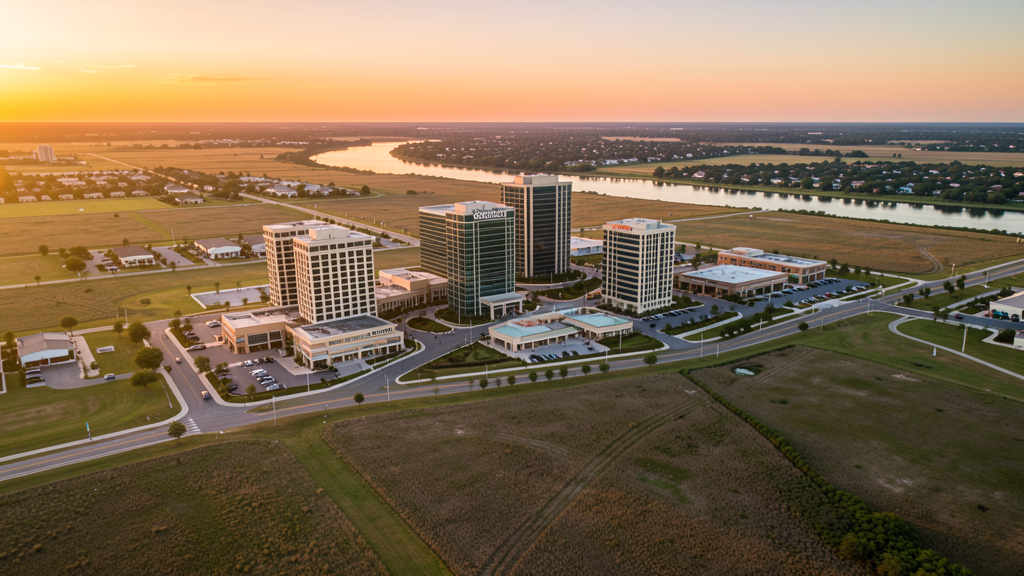
Get Matched With a Local Surveyor
Drone Survey Services Available in Sugar Land, TX
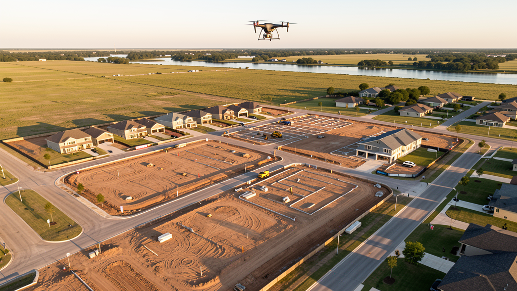
The Houston-The Woodlands-Sugar Land metro is the largest or second-largest construction market in the US, and Sugar Land is the premier corporate campus submarket in Fort Bend County. Home to Fluor Corporation, Nalco Champion, and CVR Energy, with 118,000 residents and massive MPCs (Riverstone, Telfair, Aliana), Sugar Land generates diverse survey demand. The SGR Class D airspace covering central Sugar Land and the HOU Class C shelves in eastern areas make LAANC authorization a regular requirement. The Brazos River flood risk creates ongoing demand for accurate topographic and elevation data.
Drone Surveys for Sugar Land's Construction Market
Sugar Land is the premier corporate campus city in Fort Bend County, southwest of Houston along US 59/I-69. The city is home to Fluor Corporation's global headquarters, Nalco Champion (Baker Hughes), and CVR Energy. The Sugar Land Town Square mixed-use district and the Imperial Market redevelopment anchor downtown commercial construction. Fort Bend County is one of the fastest-growing and most diverse counties in the United States, with master-planned communities including Riverstone (3,700 acres), Telfair (2,000 acres), and Aliana driving residential construction. The US 90A corridor and the Grand Parkway (TX-99) have opened new industrial and logistics development corridors. The Sugar Land Regional Airport expansion, including a new terminal and hangar construction, drives aviation-related development. Houston Methodist Sugar Land Hospital and Memorial Hermann Sugar Land Hospital expansions add medical construction demand.
Active Developers in the Area:
Typical Project Costs in Texas
Cost ranges are based on market data for Houston-The Woodlands-Sugar Land. Actual pricing depends on site size, complexity, and deliverables.
| Service Type | Low End | High End |
|---|---|---|
| Topographic Survey | $1,700 | $5,000 |
| Drone Inspection | $225 | $850 |
| LiDAR Scanning | $2,800 | $9,000 |
| Environmental Monitoring | $850 | $3,500 |
| Aerial Imagery | $175 | $500 |
| Construction Monitoring | $950 | $3,000 |
| Real Estate Photography | $175 | $500 |
| Roof Inspection | $225 | $800 |
Local Airspace & Regulations in Sugar Land, TX
FAA Part 107 Requirements
All commercial drone operations in Texas require the pilot to hold an active FAA Part 107 Remote Pilot Certificate. Our network surveyors are verified Part 107 holders.
State Drone Laws
Texas Government Code Chapter 423 restricts drone use over critical infrastructure facilities, including oil and gas pipelines, refineries, power plants, and water treatment facilities. HB 1484 (2023) added protections for agricultural operations and expanded penalties for drone surveillance of private property. Commercial operators must hold a valid FAA Part 107 Remote Pilot Certificate. Texas does not require a separate state drone license, but operators flying near critical infrastructure must obtain authorization from the facility owner. The Texas Department of Public Safety maintains additional guidelines for drone operations near state facilities.
Local Ordinances
Sugar Land does not issue a separate city-level drone permit for commercial operators. FAA Part 107 certification and LAANC authorization for Class D (SGR) and Class C (HOU) airspace are the primary requirements. Commercial filming on city property requires a permit through the Sugar Land Parks and Recreation Department. The city prohibits drone takeoff and landing in city parks without a special use permit, including Sugar Land Memorial Park, Brazos River Park, and Oyster Creek Park. Flights from private property (with owner permission) do not require a city permit but must comply with all FAA Part 107 rules and Texas Government Code Chapter 423 critical infrastructure restrictions.
Restricted Airspace
- Class D airspace around Sugar Land Regional Airport (SGR) — located within Sugar Land city limits. Drone flights within 4 nautical miles require LAANC authorization. SGR has heavy corporate jet traffic serving the Sugar Land business community, particularly during weekday commuting hours. This affects survey work throughout central Sugar Land, including the Town Square and corporate campus district.
- Class C airspace around William P. Hobby Airport (HOU) — located 18 miles east. The western shelves of HOU Class C extend into eastern Sugar Land. LAANC authorization is required for commercial flights east of SH 6 and along US 90A. Verify altitude shelves on FAA UAS Facility Maps.
- Fluor Corporation campus — major corporate campus with active security monitoring. While not designated critical infrastructure under TX Government Code Chapter 423, the campus has sensitive operations. Coordinate with Fluor security for any survey work adjacent to the campus boundary.
- Sugar Land Memorial Park and Brazos River — drone takeoff and landing is prohibited in city parks without a special use permit. The Brazos River corridor through Sugar Land is a popular recreational area where drone flights over moving watercraft during peak weekends are discouraged under FAA Part 107 rules.
- Constellation Field and Sugar Land Town Square — stadium TFRs during Sugar Land Space Cowboys (minor league baseball) games and events at Town Square prohibit drone flights within 3 nautical miles up to 3,000 ft AGL. The Town Square mixed-use district has frequent outdoor events that trigger temporary restrictions.
- Hurricane and tropical weather: Sugar Land is in a high-risk hurricane and flood zone along the Brazos River. The Barker Reservoir watershed affects the area. Drone operations during tropical storm warnings are restricted. Post-storm assessment flights require coordination with Fort Bend County Office of Emergency Management. The Brazos River has flooded multiple times in recent years, making accurate topographic data critical for flood plain mapping.
Airports in the area: undefined (undefined), undefined (undefined), undefined (undefined), undefined (undefined)
Why Hire Through Aerius View in Sugar Land, TX?
FAA-Certified
Every surveyor holds an active Part 107 Remote Pilot Certificate.
Local to Sugar Land
Surveyors who know the Texas airspace and local permitting.
No Cost to Quote
Submit your project at no charge. Pay the surveyor directly if you proceed.
Fast Turnaround
A local surveyor contacts you within 2 business days.
How Our Sugar Land Matching Process Works
We're actively building our network of FAA-certified drone operators in Sugar Land, TX. Here's exactly what happens when you submit a project request.
Submit Your Project
Tell us your site location, acreage, and what you need (topographic survey, LiDAR, inspection, etc.). Takes 60 seconds. No cost, no obligation.
We Match & Vet
We identify Part 107-certified operators in Texas with the right equipment for your project. Every pilot is verified for active certification, insurance, and relevant experience in Texas airspace.
You Get Quotes
Matched surveyors contact you within 2 business days with quotes. You compare pricing, timelines, and deliverables, then choose the right fit. You pay the surveyor directly, no markup.
What Deliverables Do You Get?
Every project includes professional-grade deliverables compatible with standard construction and engineering software:
- Orthomosaic maps (GeoTIFF) for site overview and documentation
- Point clouds (LAS/LAZ) for 3D modeling and volumetric analysis
- DEM/DSM terrain models for cut/fill and grade analysis
- Contour lines (DXF/DWG, CAD-ready) for Civil 3D and Revit
- Progress reports with side-by-side comparisons for construction monitoring
- Coordinate systems matched to your project datum (State Plane, UTM, or local)
Insurance & Liability Protection
Pilot Insurance Required
Every operator in our network must carry active liability insurance. Minimum coverage: $1,000,000 general liability. Proof of insurance is verified before any pilot joins the network.
FAA Part 107 Verified
We confirm each pilot's Remote Pilot Certificate is active and in good standing through the FAA Airmen Inquiry system. Expired certificates are flagged automatically.
Equipment Documentation
Pilots list their drone models, sensors (RGB, LiDAR, thermal, multispectral), and payload specs so we can match the right equipment to your project requirements.
Site Safety Coordination
Pilots coordinate with your site superintendent for safe operations on active construction sites, including flight plans that avoid worker areas and equipment zones.
Sugar Land, TX Drone Survey FAQs
Do I need a permit for a drone survey in Sugar Land?
Sugar Land does not issue a separate city-level drone permit for commercial operators. FAA Part 107 certification is mandatory. LAANC authorization is required for flights within the Sugar Land Regional Airport (SGR) Class D zone, which covers central Sugar Land, and for eastern areas within the Hobby Airport (HOU) Class C shelves. Flights from private property with owner permission do not require a city permit. Drone takeoff and landing in city parks requires a special use permit.
How much does a drone survey cost in Sugar Land?
Sugar Land pricing is at the upper end of the Houston metro range due to the corporate campus market. Topographic surveys typically range from $1,700 to $5,000. LiDAR scanning runs $2,800 to $9,000 for larger sites. Roof inspections cost $225 to $800 per building. Construction monitoring is typically $950 to $3,000 per month for recurring flights at MPC sites like Riverstone, Telfair, and Aliana.
Can I fly a drone near Sugar Land Regional Airport?
Sugar Land Regional Airport (SGR) is located within city limits and has Class D airspace. Drone flights within 4 nautical miles require LAANC authorization. SGR has heavy corporate jet traffic serving the Sugar Land business community, particularly during weekday commuting hours (7-9 AM and 4-6 PM). Always check FAA UAS Facility Maps for the exact boundary and altitude shelves before scheduling survey flights.
Are there no-fly zones around Constellation Field and Town Square?
Yes. Constellation Field (home of the Sugar Land Space Cowboys) has stadium TFRs during baseball games and events, prohibiting drone flights within 3 nautical miles up to 3,000 ft AGL. Sugar Land Town Square has frequent outdoor events, concerts, and festivals that may trigger temporary restrictions. Always check event schedules before scheduling survey flights near these venues.
How does the Brazos River flood risk affect drone survey work in Sugar Land?
Sugar Land is along the Brazos River, which has flooded multiple times in recent years, including during Hurricane Harvey in 2017. Accurate topographic data is critical for flood plain mapping, drainage design, and FEMA elevation certification. Post-flood damage assessment flights require coordination with Fort Bend County Office of Emergency Management. The Barker Reservoir watershed also affects eastern Sugar Land. Our surveyors use RTK GPS for centimeter-level accuracy on flood plain certification surveys.
What makes Sugar Land unique for drone survey work?
Sugar Land is the premier corporate campus city in Fort Bend County, with major employers including Fluor Corporation, Nalco Champion, and CVR Energy. The combination of corporate campus construction, massive MPCs (Riverstone, Telfair, Aliana), the Sugar Land Regional Airport expansion, and two hospital expansions creates diverse survey demand. The SGR Class D airspace covering central Sugar Land means LAANC is frequently required, but the corporate market offers higher-value contracts than typical residential survey work.
Nearby Cities
Are You a Drone Surveyor in Sugar Land?
Get pre-qualified leads in your service area. No membership fees, no monthly minimums. First lead free.
Ready to Start Your Project in Sugar Land, TX?
Get matched with a local, FAA-certified surveyor. No cost, no obligation.
Request a Free Quote