Drone Survey Services in Tomball, TX
From the SH 249 energy corridor and oil/gas service facilities to Villanova and the Grand Parkway extension, Tomball is a northwest Harris County city benefiting from Energy Corridor spillover and northward Houston expansion.
Serving Harris County & the Houston-The Woodlands-Sugar Land area
Request a Free Quote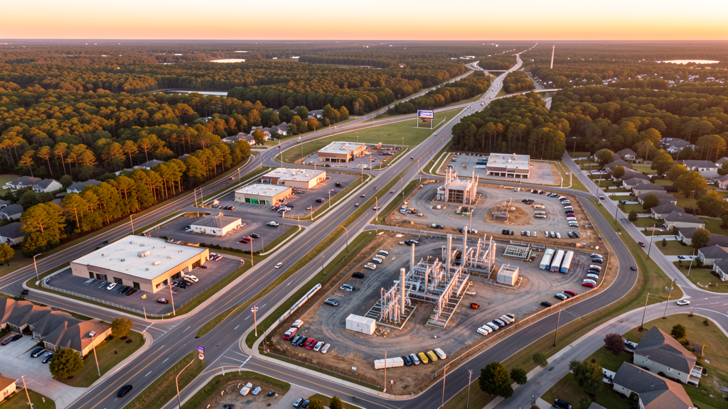
Get Matched With a Local Surveyor
Drone Survey Services Available in Tomball, TX
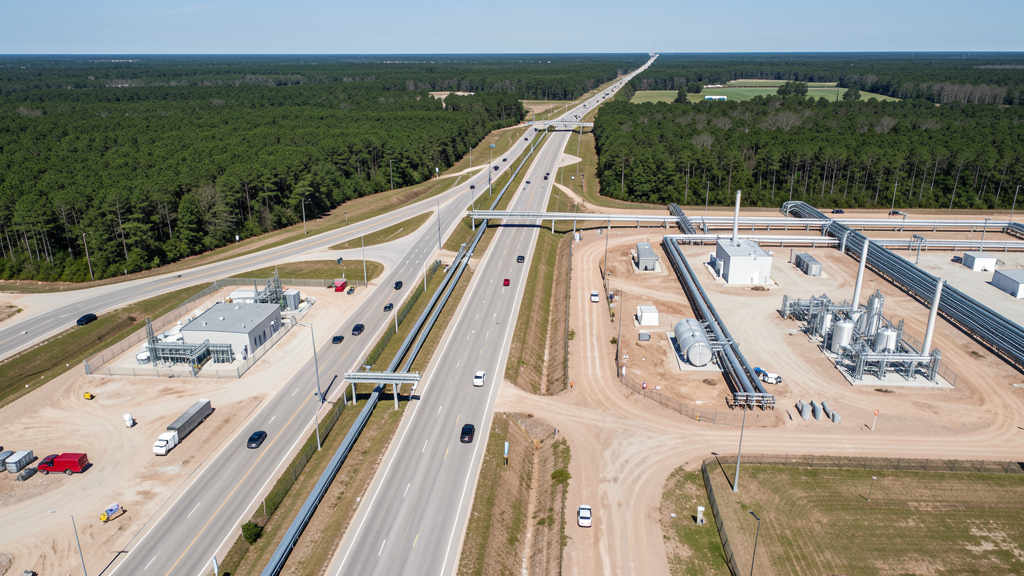
Tomball sits in northwest Harris County along SH 249, about 30 miles from downtown Houston. The city is positioned within the IAH Class B airspace shelf, requiring LAANC authorization for most commercial flights. The Tomball Energy Corridor along SH 249 is home to oil and gas service companies, driving industrial construction. The Grand Parkway (SH 99) extension has opened new development corridors. Residential growth includes Villanova, The Reserve, and several master-planned communities.
Drone Surveys for Tomball's Construction Market
Tomball is a northwest Harris County city benefiting from the Energy Corridor spillover and northward Houston expansion. The city is home to oil and gas service companies, with the Tomball Energy Corridor along SH 249 seeing commercial and industrial construction. Residential developments include Villanova, The Reserve at Tomball, and several master-planned communities along SH 249. The Tomball ISD school construction program and new medical facilities along the SH 249 corridor are significant projects. The Grand Parkway (SH 99) extension through the Tomball area has opened new land for development.
Active Developers in the Area:
Typical Project Costs in Texas
Cost ranges are based on market data for Houston-The Woodlands-Sugar Land. Actual pricing depends on site size, complexity, and deliverables.
| Service Type | Low End | High End |
|---|---|---|
| Topographic Survey | $1,800 | $4,500 |
| Drone Inspection | $250 | $850 |
| LiDAR Scanning | $2,800 | $8,000 |
| Environmental Monitoring | $800 | $3,000 |
| Aerial Imagery | $175 | $500 |
| Construction Monitoring | $1,100 | $3,200 |
| Real Estate Photography | $150 | $450 |
| Roof Inspection | $200 | $750 |
Local Airspace & Regulations in Tomball, TX
FAA Part 107 Requirements
All commercial drone operations in Texas require the pilot to hold an active FAA Part 107 Remote Pilot Certificate. Our network surveyors are verified Part 107 holders.
State Drone Laws
Texas Government Code Chapter 423 restricts drone use over critical infrastructure facilities, including oil and gas pipelines, refineries, power plants, and water treatment facilities. HB 1484 (2023) added protections for agricultural operations and expanded penalties for drone surveillance of private property. Commercial operators must hold a valid FAA Part 107 Remote Pilot Certificate. Texas does not require a separate state drone license, but operators flying near critical infrastructure must obtain authorization from the facility owner. The Texas Department of Public Safety maintains additional guidelines for drone operations near state facilities.
Local Ordinances
Tomball follows Harris County regulations and FAA Part 107 rules. No city-specific drone permit is required for operations from private property. The city is within IAH Class B airspace, requiring LAANC authorization for most commercial flights. David Wayne Hooks Memorial Airport (DWH) is only 5 miles away, with its own Class D airspace. The city prohibits drone takeoff/landing in city parks without a permit. The Tomball Energy Corridor and oil/gas service companies drive demand for industrial inspections and pipeline surveys.
Restricted Airspace
- Class B airspace around IAH extends 30 nautical miles. Tomball is within the IAH Class B shelf. LAANC authorization required for commercial drone flights.
- Class D airspace around David Wayne Hooks Memorial (DWH) — requires LAANC authorization within 4 nautical miles. DWH is only 5 miles from Tomball.
- Class D airspace around Lone Star Executive (CXO) — requires LAANC authorization within 4 nautical miles.
- Tomball city parks prohibit drone takeoff/landing without a special use permit. The Tomball Depot Plaza and historic downtown area have high pedestrian traffic.
Airports in the area: undefined (undefined), undefined (undefined), undefined (undefined), undefined (undefined)
Why Hire Through Aerius View in Tomball, TX?
FAA-Certified
Every surveyor holds an active Part 107 Remote Pilot Certificate.
Local to Tomball
Surveyors who know the Texas airspace and local permitting.
No Cost to Quote
Submit your project at no charge. Pay the surveyor directly if you proceed.
Fast Turnaround
A local surveyor contacts you within 2 business days.
How Our Tomball Matching Process Works
We're actively building our network of FAA-certified drone operators in Tomball, TX. Here's exactly what happens when you submit a project request.
Submit Your Project
Tell us your site location, acreage, and what you need (topographic survey, LiDAR, inspection, etc.). Takes 60 seconds. No cost, no obligation.
We Match & Vet
We identify Part 107-certified operators in Texas with the right equipment for your project. Every pilot is verified for active certification, insurance, and relevant experience in Texas airspace.
You Get Quotes
Matched surveyors contact you within 2 business days with quotes. You compare pricing, timelines, and deliverables, then choose the right fit. You pay the surveyor directly, no markup.
What Deliverables Do You Get?
Every project includes professional-grade deliverables compatible with standard construction and engineering software:
- Orthomosaic maps (GeoTIFF) for site overview and documentation
- Point clouds (LAS/LAZ) for 3D modeling and volumetric analysis
- DEM/DSM terrain models for cut/fill and grade analysis
- Contour lines (DXF/DWG, CAD-ready) for Civil 3D and Revit
- Progress reports with side-by-side comparisons for construction monitoring
- Coordinate systems matched to your project datum (State Plane, UTM, or local)
Insurance & Liability Protection
Pilot Insurance Required
Every operator in our network must carry active liability insurance. Minimum coverage: $1,000,000 general liability. Proof of insurance is verified before any pilot joins the network.
FAA Part 107 Verified
We confirm each pilot's Remote Pilot Certificate is active and in good standing through the FAA Airmen Inquiry system. Expired certificates are flagged automatically.
Equipment Documentation
Pilots list their drone models, sensors (RGB, LiDAR, thermal, multispectral), and payload specs so we can match the right equipment to your project requirements.
Site Safety Coordination
Pilots coordinate with your site superintendent for safe operations on active construction sites, including flight plans that avoid worker areas and equipment zones.
Tomball, TX Drone Survey FAQs
Do I need a permit for a drone survey in Tomball?
No city-specific permit is required for commercial drone operations from private property in Tomball. However, the city is within IAH Class B airspace, which requires LAANC authorization for most commercial flights. David Wayne Hooks Memorial Airport Class D airspace is only 5 miles away. Takeoff/landing in city parks requires a permit.
How much does a drone survey cost in Tomball, TX?
Topographic surveys in Harris County typically range from $1,800 to $4,500. Roof inspections run $200-$750. LiDAR scanning for industrial or energy sector sites costs $2,800-$8,000. Pipeline and infrastructure inspections start at $800.
Can I fly a drone near Bush Intercontinental Airport from Tomball?
Tomball is within the IAH Class B airspace shelf. Most commercial drone flights in Tomball require LAANC authorization. David Wayne Hooks Memorial Airport (DWH) is only 5 miles SW with its own Class D airspace. Our surveyors handle all LAANC approvals automatically.
What construction projects need drone surveys in Tomball?
The SH 249 energy corridor commercial and industrial construction, Villanova and The Reserve residential developments, Tomball ISD school construction, and Grand Parkway (SH 99) extension projects all require aerial surveys. The oil and gas service sector also drives pipeline inspection demand.
How long does a topographic survey take in Tomball?
A standard 50-acre site can be flown in under an hour, weather and LAANC authorization permitting. Deliverables including DEM, contour maps, orthomosaic, and point cloud are ready within 3-5 business days. The flat terrain makes flights straightforward, but IAH airspace coordination may add scheduling time.
Nearby Cities
Are You a Drone Surveyor in Tomball?
Get pre-qualified leads in your service area. No membership fees, no monthly minimums. First lead free.
Ready to Start Your Project in Tomball, TX?
Get matched with a local, FAA-certified surveyor. No cost, no obligation.
Request a Free Quote