Drone Survey Services in Dallas, TX
From Deep Ellum's mixed-use towers and the Design District's luxury conversions to the multi-billion-dollar Trinity River Corridor Project, Dallas is a top-three US construction market where $35B+ in annual development creates constant demand for aerial survey across the Metroplex.
Serving Dallas County & the Dallas-Fort Worth-Arlington area
Request a Free Quote
Get Matched With a Local Surveyor
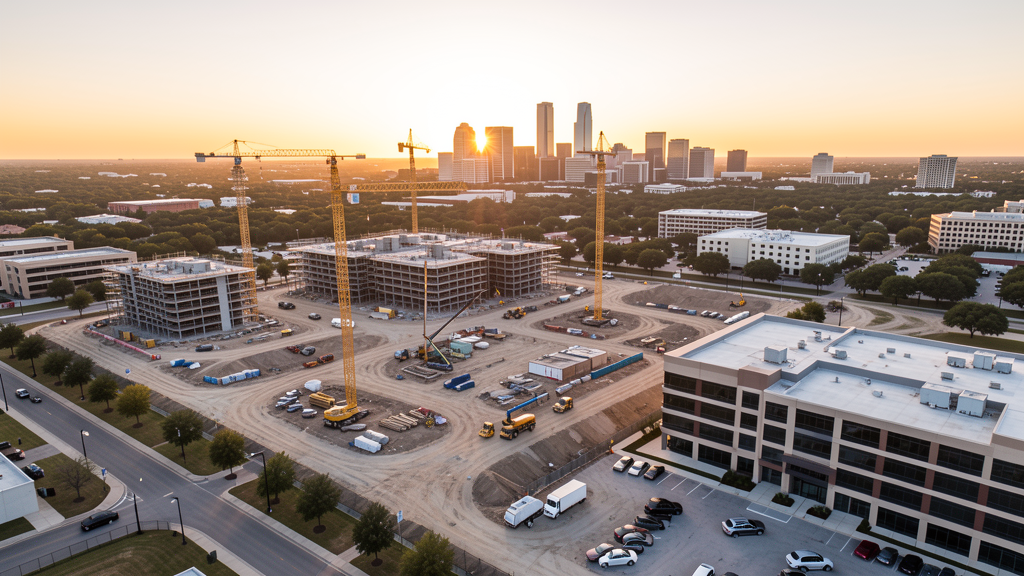
Drone Survey Services Available in Dallas, TX
The Dallas-Fort Worth-Arlington metro is the fourth-largest metropolitan area in the United States with 7.6 million residents, and Dallas is its cultural and economic hub at 1.3 million people. As the third-largest US construction market, Dallas generates $35B+ in annual construction volume, driven by mixed-use development in Deep Ellum, the Design District, and Uptown; the Trinity River Corridor Project; highway expansion on I-35E and US-75; and institutional campus growth. The city's two Class B airports (DAL and DFW) and two Class D airports (RBD and ADS) create one of the most complex drone airspace environments in the nation.
Drone Surveys for Dallas's Construction Market
Dallas is the third-largest construction market in the United States, with $35B+ in annual construction volume. The Dallas-Fort Worth-Arlington metro added more than 100,000 residents annually in recent years, driving massive residential and commercial development. Deep Ellum continues its transformation from entertainment district to mixed-use neighborhood with residential towers, office space, and ground-floor retail. The Design District along Turtle Creek Boulevard has become a luxury residential and hospitality corridor, with high-rise condominiums and hotels replacing former warehouses. Uptown Dallas along McKinney Avenue is one of the most active high-density residential markets in the country. Preston Center and the Far North Dallas corridor along the Dallas North Tollway continue to see mid-rise office and medical office development. The Southern Dallas redevelopment initiative, anchored by the Trinity River Corridor Project, is a multi-billion-dollar infrastructure and development effort spanning 20 miles of riverfront. The I-35E and US-75 highway expansion projects generate heavy civil survey demand. The Presbyterian Hospital and Baylor Scott & White medical campus expansions add institutional construction. Downtown Dallas continues to see office-to-residential conversions and new high-rise development in the Arts District and the Main Street corridor.
Active Developers in the Area:
Typical Project Costs in Texas
Cost ranges are based on market data for Dallas-Fort Worth-Arlington. Actual pricing depends on site size, complexity, and deliverables.
| Service Type | Low End | High End |
|---|---|---|
| Topographic Survey | $1,800 | $5,500 |
| Drone Inspection | $250 | $900 |
| LiDAR Scanning | $2,800 | $10,000 |
| Environmental Monitoring | $900 | $4,000 |
| Aerial Imagery | $200 | $550 |
| Construction Monitoring | $1,000 | $3,200 |
| Real Estate Photography | $175 | $500 |
| Roof Inspection | $225 | $850 |
Local Airspace & Regulations in Dallas, TX
FAA Part 107 Requirements
All commercial drone operations in Texas require the pilot to hold an active FAA Part 107 Remote Pilot Certificate. Our network surveyors are verified Part 107 holders.
State Drone Laws
Texas Government Code Chapter 423 restricts drone use over critical infrastructure facilities, including oil and gas pipelines, refineries, power plants, and water treatment facilities. HB 1484 (2023) added protections for agricultural operations and expanded penalties for drone surveillance of private property. Commercial operators must hold a valid FAA Part 107 Remote Pilot Certificate. Texas does not require a separate state drone license, but operators flying near critical infrastructure must obtain authorization from the facility owner. The Texas Department of Public Safety maintains additional guidelines for drone operations near state facilities.
Local Ordinances
The City of Dallas does not issue a separate city-level drone permit for commercial operators. FAA Part 107 certification and LAANC authorization for Class B (DAL, DFW) and Class D (RBD, ADS) airspace are the primary requirements. The Dallas Park and Recreation Department prohibits drone takeoff and landing in city parks — including White Rock Lake Park, Klyde Warren Park, and the Dallas Arboretum — without a special use permit. Commercial filming on city property requires a permit through the Dallas Office of Cultural Affairs and the Dallas Film Commission. Flights within the downtown Dallas core (Central Business District) should be coordinated with the Dallas Police Department Aviation Unit, which operates helicopter patrols from Dallas Love Field. Drone flights over the Trinity River corridor and levee system are subject to US Army Corps of Engineers and Dallas Water Utilities restrictions. All flights must comply with FAA Part 107 rules and Texas Government Code Chapter 423 critical infrastructure prohibitions.
Restricted Airspace
- Class B airspace around Dallas Love Field (DAL) — located 6 miles northwest of downtown. The DAL Class B surface area covers central and northwest Dallas including the Design District, Turtle Creek, and Oak Lawn. LAANC authorization is required for all commercial drone flights in this zone. Altitude restrictions are stringent — check FAA UAS Facility Maps for specific grid authorizations, as many areas allow only 0-50 ft AGL or require manual authorization.
- Class B airspace around Dallas-Fort Worth International Airport (DFW) — located 18 miles northwest. DFW is one of the largest airports in the world by land area and passenger volume. The Class B surface area and shelves extend across much of northern and western Dallas County, affecting survey work in Irving, Farmers Branch, Carrollton, and the North Dallas Tollway corridor. LAANC is required throughout this zone. The DFW Class B is one of the most complex airspace environments in the country for drone operations.
- Class D airspace around Dallas Executive Airport (RBD) — located 9 miles southwest in the Red Bird/Oak Cliff area. Drone flights within 4 nautical miles require LAANC authorization. This affects survey work in southern Dallas, Oak Cliff, and the I-35E southern corridor toward Lancaster and DeSoto.
- Class D airspace around Addison Airport (ADS) — located 12 miles north in Addison. ADS is the busiest general aviation airport in Texas with heavy corporate jet and training traffic. LAANC is required within 4 nautical miles, affecting survey work in North Dallas, Addison, and the Far North Dallas commercial corridors along the Dallas North Tollway and Preston Road.
- Stadium TFRs — AT&T Stadium (Arlington, home of the Dallas Cowboys), American Airlines Center (downtown Dallas, home of the Mavericks and Stars), and Globe Life Field (Arlington, Texas Rangers) all have active stadium TFRs during sporting events. Drone flights within 3 nautical miles up to 3,000 ft AGL are prohibited during NFL, NBA, NHL, and MLB games. The American Airlines Center TFR directly affects downtown Dallas and the Design District. Always check event schedules before scheduling flights near these venues.
- Texas State Fairgrounds (Fair Park) — during the State Fair of Texas (late September through mid-October), the fairgrounds and surrounding South Dallas area have enhanced security and drone restrictions. The Cotton Bowl Stadium within Fair Park has stadium TFRs during college football games. Coordinate with Dallas Police and Fair Park security for any survey work during fair season.
- Critical infrastructure — Trinity River levee system, the Dallas Water Utilities treatment plants, and the AT&T corporate campus in Akard all fall under Texas Government Code Chapter 423 critical infrastructure restrictions. Drone flights over these facilities are restricted without explicit authorization from the facility operator.
- Severe weather — Dallas is in the southern Great Plains tornado alley and experiences severe thunderstorms, tornadoes, and high winds from April through June. Flash flooding along the Trinity River and White Rock Creek is common. Post-storm survey work requires coordination with Dallas Office of Emergency Management. Summer heat (100+°F days common June through September) limits flight windows to early morning and late evening. High density altitude on hot days reduces drone payload capacity.
Airports in the area: undefined (undefined), undefined (undefined), undefined (undefined), undefined (undefined)
Why Hire Through Aerius View in Dallas, TX?
FAA-Certified
Every surveyor holds an active Part 107 Remote Pilot Certificate.
Local to Dallas
Surveyors who know the Texas airspace and local permitting.
No Cost to Quote
Submit your project at no charge. Pay the surveyor directly if you proceed.
Fast Turnaround
A local surveyor contacts you within 2 business days.
How Our Dallas Matching Process Works
We're actively building our network of FAA-certified drone operators in Dallas, TX. Here's exactly what happens when you submit a project request.
Submit Your Project
Tell us your site location, acreage, and what you need (topographic survey, LiDAR, inspection, etc.). Takes 60 seconds. No cost, no obligation.
We Match & Vet
We identify Part 107-certified operators in Texas with the right equipment for your project. Every pilot is verified for active certification, insurance, and relevant experience in Texas airspace.
You Get Quotes
Matched surveyors contact you within 2 business days with quotes. You compare pricing, timelines, and deliverables, then choose the right fit. You pay the surveyor directly, no markup.
What Deliverables Do You Get?
Every project includes professional-grade deliverables compatible with standard construction and engineering software:
- Orthomosaic maps (GeoTIFF) for site overview and documentation
- Point clouds (LAS/LAZ) for 3D modeling and volumetric analysis
- DEM/DSM terrain models for cut/fill and grade analysis
- Contour lines (DXF/DWG, CAD-ready) for Civil 3D and Revit
- Progress reports with side-by-side comparisons for construction monitoring
- Coordinate systems matched to your project datum (State Plane, UTM, or local)
Insurance & Liability Protection
Pilot Insurance Required
Every operator in our network must carry active liability insurance. Minimum coverage: $1,000,000 general liability. Proof of insurance is verified before any pilot joins the network.
FAA Part 107 Verified
We confirm each pilot's Remote Pilot Certificate is active and in good standing through the FAA Airmen Inquiry system. Expired certificates are flagged automatically.
Equipment Documentation
Pilots list their drone models, sensors (RGB, LiDAR, thermal, multispectral), and payload specs so we can match the right equipment to your project requirements.
Site Safety Coordination
Pilots coordinate with your site superintendent for safe operations on active construction sites, including flight plans that avoid worker areas and equipment zones.
Dallas, TX Drone Survey FAQs
Do I need a permit for a drone survey in Dallas?
The City of Dallas does not issue a separate city-level drone permit for commercial operators. FAA Part 107 certification is mandatory. However, LAANC authorization is required for most of central and northern Dallas, which falls within the DAL Class B or DFW Class B airspace. Southern Dallas near Dallas Executive Airport (RBD) requires LAANC for the Class D zone. North Dallas near Addison Airport (ADS) also requires LAANC for the Class D zone. Drone takeoff and landing in city parks requires a special use permit from Dallas Park and Recreation. Commercial filming on city property requires a permit through the Dallas Film Commission.
How much does a drone survey cost in Dallas?
Dallas is a top-three US construction market with correspondingly high demand for survey services. Topographic surveys typically range from $1,800 to $5,500. LiDAR scanning runs $2,800 to $10,000 for wooded or urban canyon sites along the Trinity River. Roof inspections cost $225 to $850 per building, with volume discounts for commercial portfolios in the Design District and Uptown. Construction monitoring is typically $1,000 to $3,200 per month for recurring flights at major developments like Deep Ellum and the Trinity River Corridor Project.
How does DFW International Airport affect drone operations in Dallas?
DFW International Airport is one of the largest and busiest airports in the world, and its Class B airspace covers much of northern and western Dallas County. The Class B surface area and shelves extend across Irving, Farmers Branch, Carrollton, and the North Dallas Tollway corridor. LAANC authorization is required throughout this zone. The DFW Class B is one of the most complex airspace environments in the country — many grid authorizations allow only 0-50 ft AGL, and some areas require manual authorization that can take days. Always check FAA UAS Facility Maps and plan flights well in advance for work near the DFW footprint.
Can I fly a drone near downtown Dallas and the Arts District?
Downtown Dallas falls within the DAL Class B surface area, so LAANC authorization is required. The American Airlines Center (home of the Mavericks and Stars) has stadium TFRs during games that prohibit flights within 3 nautical miles up to 3,000 ft AGL. Flights within the downtown core should be coordinated with the Dallas Police Department Aviation Unit, which operates helicopter patrols from Love Field. Klyde Warren Park and the Dallas Arboretum prohibit drone takeoff and landing without a special use permit. The Arts District and Main Street corridor have dense high-rise development — maintain visual line of sight and respect FAA Part 107 altitude limits.
Are there restrictions near the Trinity River Corridor Project?
Yes. The Trinity River levee system is classified as critical infrastructure under Texas Government Code Chapter 423, meaning drone flights over the levees and floodway are restricted without authorization from the US Army Corps of Engineers and Dallas Water Utilities. The Trinity River Corridor Project is a multi-billion-dollar redevelopment spanning 20 miles of riverfront, and survey work in this zone requires coordination with the City of Dallas Trinity River Corridor Project Office. Post-flood survey work along the Trinity requires coordination with Dallas Office of Emergency Management. Flash flooding along the Trinity and White Rock Creek is common during spring thunderstorms.
What makes Dallas unique for drone survey work?
Dallas is the third-largest construction market in the United States with $35B+ in annual construction volume and a metro population of 7.6 million. The combination of massive mixed-use development in Deep Ellum and the Design District, luxury residential towers in Uptown and Turtle Creek, the multi-billion-dollar Trinity River Corridor Project, and continuous highway expansion (I-35E, US-75) creates some of the most diverse and high-volume survey demand in the country. However, Dallas also has one of the most complex airspace environments — two major Class B airports (DAL and DFW) plus two Class D airports (RBD and ADS) — meaning most commercial flights require LAANC authorization. The market rewards operators who can navigate the airspace efficiently while serving the Metroplex's enormous development pipeline.
Nearby Cities
Are You a Drone Surveyor in Dallas?
Get pre-qualified leads in your service area. No membership fees, no monthly minimums. First lead free.
Ready to Start Your Project in Dallas, TX?
Get matched with a local, FAA-certified surveyor. No cost, no obligation.
Request a Free Quote