Drone Survey Services in Forney, TX
From Travis Farms and Heartland to the Highway 80 business park, Forney is the fastest-growing city in the DFW metro by percentage, with population doubling since 2015 as eastward expansion drives nonstop residential and commercial construction.
Serving Kaufman County & the Dallas-Fort Worth-Arlington area
Request a Free Quote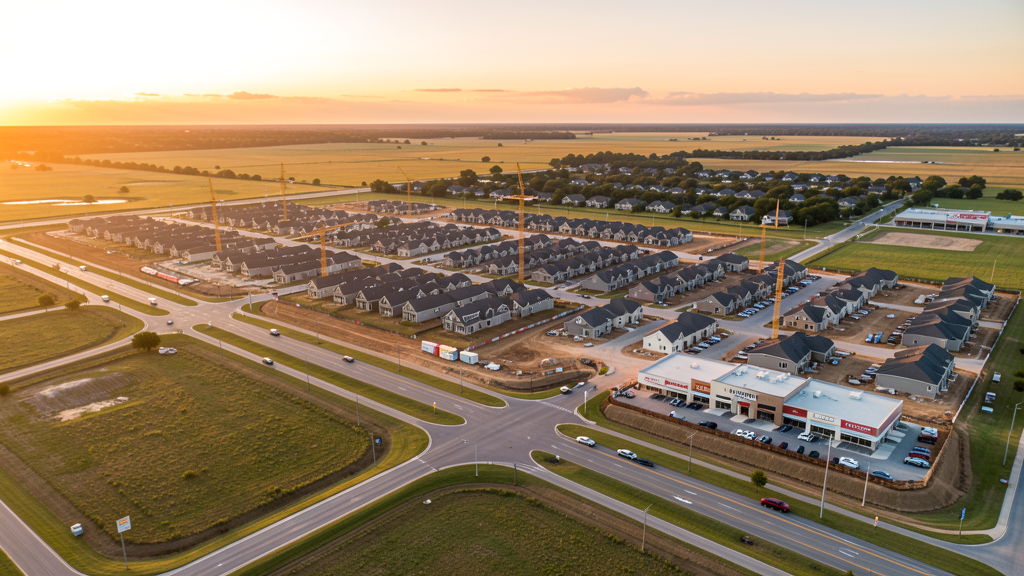
Get Matched With a Local Surveyor
Drone Survey Services Available in Forney, TX
Forney sits in eastern Kaufman County along I-20 and US Highway 80, positioned as the primary beneficiary of DFW's eastward expansion. The city has doubled in population since 2015 and Kaufman County consistently leads the region in residential permit volume. The Forney Business Park along Highway 80 is attracting warehouse and light industrial tenants, while master-planned residential communities extend eastward from the Dallas metro boundary.
Drone Surveys for Forney's Construction Market
Forney is the fastest-growing city in the DFW metro area by percentage, with population doubling since 2015. The city is the primary beneficiary of eastward DFW expansion along I-20 and US Highway 80. Major residential developments include Travis Farms, Heartland, and Diamond Creek, each with hundreds of homes under construction. The Forney Business Park along Highway 80 is attracting warehouse and light industrial construction. Kaufman County issued over 3,000 residential building permits in the most recent year, with Forney accounting for a significant share.
Active Developers in the Area:
Typical Project Costs in Texas
Cost ranges are based on market data for Dallas-Fort Worth-Arlington. Actual pricing depends on site size, complexity, and deliverables.
| Service Type | Low End | High End |
|---|---|---|
| Topographic Survey | $1,800 | $4,500 |
| Drone Inspection | $250 | $850 |
| LiDAR Scanning | $2,800 | $8,000 |
| Environmental Monitoring | $800 | $3,000 |
| Aerial Imagery | $150 | $500 |
| Construction Monitoring | $1,100 | $3,200 |
| Real Estate Photography | $150 | $450 |
| Roof Inspection | $200 | $750 |
Local Airspace & Regulations in Forney, TX
FAA Part 107 Requirements
All commercial drone operations in Texas require the pilot to hold an active FAA Part 107 Remote Pilot Certificate. Our network surveyors are verified Part 107 holders.
State Drone Laws
Texas Government Code Chapter 423 restricts drone use over critical infrastructure facilities, including oil and gas pipelines, refineries, power plants, and water treatment facilities. HB 1484 (2023) added protections for agricultural operations and expanded penalties for drone surveillance of private property. Commercial operators must hold a valid FAA Part 107 Remote Pilot Certificate. Texas does not require a separate state drone license, but operators flying near critical infrastructure must obtain authorization from the facility owner. The Texas Department of Public Safety maintains additional guidelines for drone operations near state facilities.
Local Ordinances
Forney follows Kaufman County regulations and FAA Part 107 rules. No city-specific drone permit is required for operations from private property. The city prohibits drone takeoff/landing in city parks without prior permission. Commercial flights in the western portion of Forney near US 80 may require LAANC authorization due to DFW Class B airspace. The Forney Economic Development Corporation actively supports commercial and industrial development, often requiring aerial surveys.
Restricted Airspace
- Class B airspace around DFW and Dallas Love Field extends into the western edge of Kaufman County. LAANC authorization required for commercial drone flights within this zone.
- Terrell Municipal Airport (TRL) has Class E airspace — no LAANC required but pilots must maintain visual line of sight and notify tower if operating within 5 miles.
- Kaufman County has no county-wide drone ordinance. Forney city parks prohibit takeoff/landing without permission from the Parks and Recreation Department.
- US Highway 80 corridor construction zones may have temporary flight restrictions during active construction work.
Airports in the area: undefined (undefined), undefined (undefined), undefined (undefined), undefined (undefined)
Why Hire Through Aerius View in Forney, TX?
FAA-Certified
Every surveyor holds an active Part 107 Remote Pilot Certificate.
Local to Forney
Surveyors who know the Texas airspace and local permitting.
No Cost to Quote
Submit your project at no charge. Pay the surveyor directly if you proceed.
Fast Turnaround
A local surveyor contacts you within 2 business days.
How Our Forney Matching Process Works
We're actively building our network of FAA-certified drone operators in Forney, TX. Here's exactly what happens when you submit a project request.
Submit Your Project
Tell us your site location, acreage, and what you need (topographic survey, LiDAR, inspection, etc.). Takes 60 seconds. No cost, no obligation.
We Match & Vet
We identify Part 107-certified operators in Texas with the right equipment for your project. Every pilot is verified for active certification, insurance, and relevant experience in Texas airspace.
You Get Quotes
Matched surveyors contact you within 2 business days with quotes. You compare pricing, timelines, and deliverables, then choose the right fit. You pay the surveyor directly, no markup.
What Deliverables Do You Get?
Every project includes professional-grade deliverables compatible with standard construction and engineering software:
- Orthomosaic maps (GeoTIFF) for site overview and documentation
- Point clouds (LAS/LAZ) for 3D modeling and volumetric analysis
- DEM/DSM terrain models for cut/fill and grade analysis
- Contour lines (DXF/DWG, CAD-ready) for Civil 3D and Revit
- Progress reports with side-by-side comparisons for construction monitoring
- Coordinate systems matched to your project datum (State Plane, UTM, or local)
Insurance & Liability Protection
Pilot Insurance Required
Every operator in our network must carry active liability insurance. Minimum coverage: $1,000,000 general liability. Proof of insurance is verified before any pilot joins the network.
FAA Part 107 Verified
We confirm each pilot's Remote Pilot Certificate is active and in good standing through the FAA Airmen Inquiry system. Expired certificates are flagged automatically.
Equipment Documentation
Pilots list their drone models, sensors (RGB, LiDAR, thermal, multispectral), and payload specs so we can match the right equipment to your project requirements.
Site Safety Coordination
Pilots coordinate with your site superintendent for safe operations on active construction sites, including flight plans that avoid worker areas and equipment zones.
Forney, TX Drone Survey FAQs
Do I need a permit for a drone survey in Forney?
No city-specific permit is required for commercial drone operations from private property in Forney. All flights must comply with FAA Part 107 rules. Operations in the western part of the city near US 80 may require LAANC authorization for DFW Class B airspace. Takeoff/landing in city parks requires permission from Parks and Recreation.
How much does a drone survey cost in Forney, TX?
Topographic surveys in Kaufman County typically range from $1,800 to $4,500. Roof inspections run $200-$750. LiDAR scanning for larger residential or commercial sites costs $2,800-$8,000. Real estate drone photography starts at $150.
Is Forney in DFW controlled airspace?
The western edge of Forney near US Highway 80 falls within the outer shelf of DFW Class B airspace. Most residential development east of the city center is in uncontrolled Class E airspace. Our network surveyors check airspace status before every flight and handle LAANC authorizations automatically.
What is driving construction growth in Forney?
Forney is the fastest-growing city in the DFW metro by percentage growth rate. Travis Farms, Heartland, and Diamond Creek are among the largest active residential developments. The Forney Business Park along Highway 80 is adding warehouse and light industrial space. Kaufman County issued over 3,000 residential permits last year.
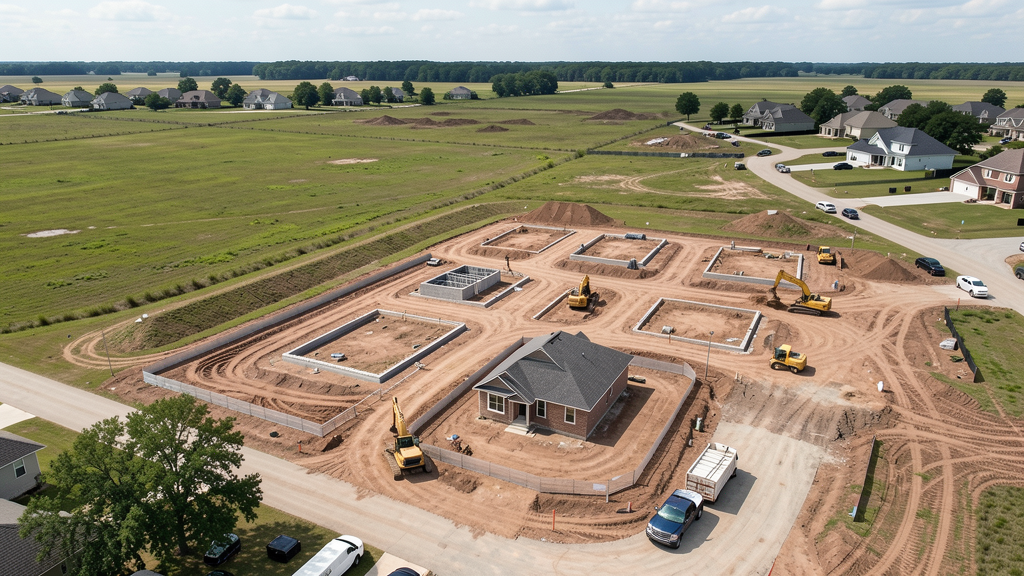
How long does a topographic survey take in Forney?
A standard 50-acre residential site can be flown in under an hour. Deliverables including DEM, contour maps, orthomosaic, and point cloud are ready within 3-5 business days. The terrain is relatively flat, making flights straightforward. Summer heat may limit flights to early morning hours.
Nearby Cities
Are You a Drone Surveyor in Forney?
Get pre-qualified leads in your service area. No membership fees, no monthly minimums. First lead free.
Ready to Start Your Project in Forney, TX?
Get matched with a local, FAA-certified surveyor. No cost, no obligation.
Request a Free Quote