Drone Survey Services in Plano, TX
From Toyota North America HQ and JPMorgan Chase Legacy West to The Star (Cowboys HQ) and Legacy Town Center, Plano is the corporate campus capital of DFW where 300,000+ daytime workers drive high-value survey demand under triple-airspace LAANC complexity.
Serving Collin County & the Dallas-Fort Worth-Arlington area
Request a Free Quote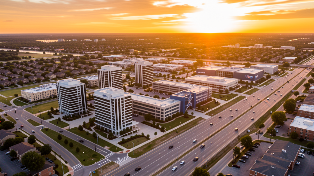
Get Matched With a Local Surveyor
Drone Survey Services Available in Plano, TX
The Dallas-Fort Worth-Arlington metro is the 4th-largest US metro, and Plano is its corporate campus capital with 290,000 residents and 300,000+ daytime workers. Legacy West (Toyota, JPMorgan Chase, Liberty Mutual), The Star (Dallas Cowboys HQ), and Legacy Town Center anchor a high-value corporate survey market. The triple-airspace overlap (ADS Class D, DFW Class B, TKI Class D) makes LAANC planning essential for every survey job in Plano.
Drone Surveys for Plano's Construction Market
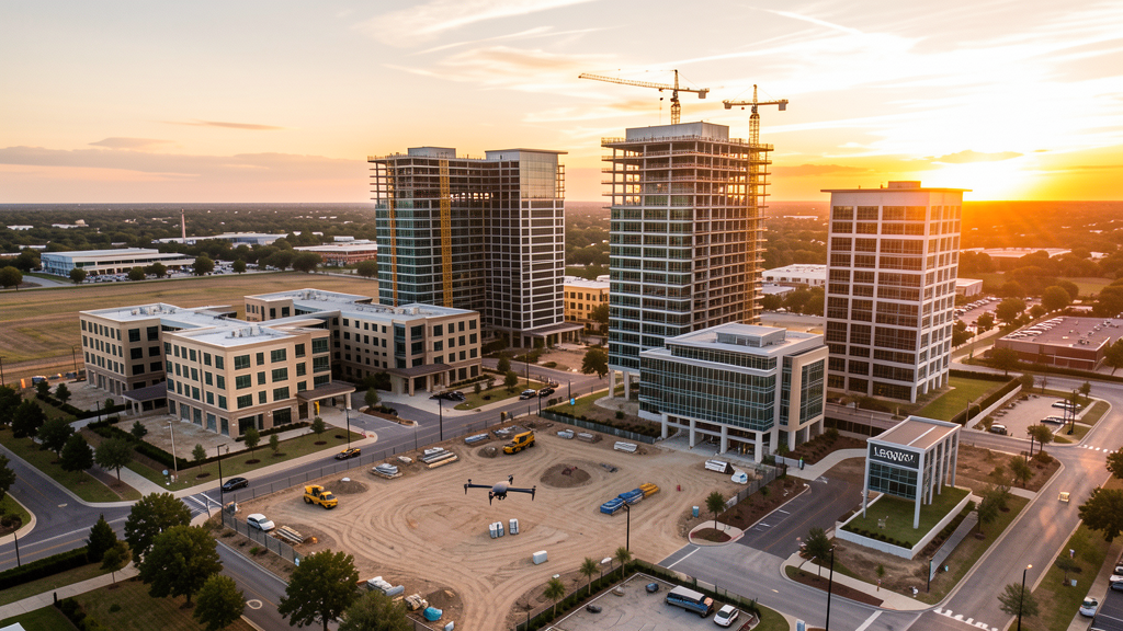
Plano is the corporate campus capital of DFW, anchored by Legacy West (JPMorgan Chase, Toyota North America HQ, Liberty Mutual, and Mixed-Use development), The Star (Dallas Cowboys World Headquarters and training facility), and Legacy Town Center. The city has transitioned from a residential suburb to a major corporate employment center with 300,000+ daytime workers. The Legacy West phase II expansion, Toyota campus expansion, and The Star mixed-use development drive high-value corporate campus survey demand. The Dallas North Tollway extension and SH 121 improvements create heavy civil survey work. Collin County is the fastest-growing county in DFW, with Plano serving as its southern employment anchor. Corporate campus construction monitoring, roof inspections on large-format office buildings, and parking lot/mall site surveys are the primary drone survey use cases.
Active Developers in the Area:
Typical Project Costs in Texas
Cost ranges are based on market data for Dallas-Fort Worth-Arlington. Actual pricing depends on site size, complexity, and deliverables.
| Service Type | Low End | High End |
|---|---|---|
| Topographic Survey | $1,700 | $5,000 |
| Drone Inspection | $250 | $800 |
| LiDAR Scanning | $2,700 | $9,000 |
| Environmental Monitoring | $875 | $3,500 |
| Aerial Imagery | $200 | $500 |
| Construction Monitoring | $950 | $2,800 |
| Real Estate Photography | $175 | $450 |
| Roof Inspection | $225 | $750 |
Local Airspace & Regulations in Plano, TX
FAA Part 107 Requirements
All commercial drone operations in Texas require the pilot to hold an active FAA Part 107 Remote Pilot Certificate. Our network surveyors are verified Part 107 holders.
State Drone Laws
Texas Government Code Chapter 423 restricts drone use over critical infrastructure facilities, including oil and gas pipelines, refineries, power plants, and water treatment facilities. HB 1484 (2023) added protections for agricultural operations and expanded penalties for drone surveillance of private property. Commercial operators must hold a valid FAA Part 107 Remote Pilot Certificate. Texas does not require a separate state drone license, but operators flying near critical infrastructure must obtain authorization from the facility owner. The Texas Department of Public Safety maintains additional guidelines for drone operations near state facilities.
Local Ordinances
Plano does not issue a separate city-level drone permit for commercial operators. FAA Part 107 certification and LAANC authorization for ADS Class D, DFW Class B, and TKI Class D airspace are the primary requirements. Commercial filming on city property requires a permit through the Plano Parks and Recreation Department. Drone takeoff and landing in Plano parks requires a special use permit, including Arbor Hills Nature Preserve, Oak Point Park, and Preston Meadow Park. The Legacy West mixed-use development and The Star complex have private property restrictions on drone takeoff and landing. Flights over corporate campuses (Toyota, JPMorgan Chase, Liberty Mutual, JC Penney) should be coordinated with corporate security.
Restricted Airspace
- Class D airspace around Addison Airport (ADS) — located 3 miles south. ADS is one of the busiest GA airports in Texas with heavy corporate jet traffic. LAANC authorization required for flights in southern Plano. The ADS Class D extends into the Legacy Drive and Tollway corridor area.
- Class B airspace around DFW International — southwestern Plano falls within DFW Class B shelves. LAANC authorization required for all commercial drone flights in western Plano near the Tollway and SH 121 corridor.
- Class D airspace around McKinney National Airport (TKI) — located 10 miles north. Northern Plano near Legacy Hills and Windhaven Meadows falls within TKI Class D. LAANC authorization required.
- The Star (Dallas Cowboys World Headquarters) — stadium TFRs during Cowboys events and practices prohibit drone flights within 3 nautical miles up to 3,000 ft AGL. The Star complex on Cowboys Way includes practice facilities, corporate offices, and entertainment venues.
- Toyota North America HQ campus — while not formal restricted airspace, the 100-acre Toyota headquarters campus has active security monitoring. Drone flights over the campus should be coordinated with Toyota security, especially during corporate events.
- JPMorgan Chase Legacy West campus — large corporate campus with security monitoring. Coordinate drone flights over the Legacy West mixed-use development with property management.
- Dr. Pepper Ballpark (Frisco RoughRiders) — located 5 miles north in Frisco. Stadium TFRs during baseball games prohibit drone flights within 3 nautical miles up to 3,000 ft AGL.
- Severe weather: Plano is in the DFW metro tornado risk zone. Spring thunderstorms (April-June) can produce tornadoes and large hail. Post-storm roof inspection and commercial property damage documentation is a significant drone survey use case.
Airports in the area: undefined (undefined), undefined (undefined), undefined (undefined)
Why Hire Through Aerius View in Plano, TX?
FAA-Certified
Every surveyor holds an active Part 107 Remote Pilot Certificate.
Local to Plano
Surveyors who know the Texas airspace and local permitting.
No Cost to Quote
Submit your project at no charge. Pay the surveyor directly if you proceed.
Fast Turnaround
A local surveyor contacts you within 2 business days.
How Our Plano Matching Process Works
We're actively building our network of FAA-certified drone operators in Plano, TX. Here's exactly what happens when you submit a project request.
Submit Your Project
Tell us your site location, acreage, and what you need (topographic survey, LiDAR, inspection, etc.). Takes 60 seconds. No cost, no obligation.
We Match & Vet
We identify Part 107-certified operators in Texas with the right equipment for your project. Every pilot is verified for active certification, insurance, and relevant experience in Texas airspace.
You Get Quotes
Matched surveyors contact you within 2 business days with quotes. You compare pricing, timelines, and deliverables, then choose the right fit. You pay the surveyor directly, no markup.
What Deliverables Do You Get?
Every project includes professional-grade deliverables compatible with standard construction and engineering software:
- Orthomosaic maps (GeoTIFF) for site overview and documentation
- Point clouds (LAS/LAZ) for 3D modeling and volumetric analysis
- DEM/DSM terrain models for cut/fill and grade analysis
- Contour lines (DXF/DWG, CAD-ready) for Civil 3D and Revit
- Progress reports with side-by-side comparisons for construction monitoring
- Coordinate systems matched to your project datum (State Plane, UTM, or local)
Insurance & Liability Protection
Pilot Insurance Required
Every operator in our network must carry active liability insurance. Minimum coverage: $1,000,000 general liability. Proof of insurance is verified before any pilot joins the network.
FAA Part 107 Verified
We confirm each pilot's Remote Pilot Certificate is active and in good standing through the FAA Airmen Inquiry system. Expired certificates are flagged automatically.
Equipment Documentation
Pilots list their drone models, sensors (RGB, LiDAR, thermal, multispectral), and payload specs so we can match the right equipment to your project requirements.
Site Safety Coordination
Pilots coordinate with your site superintendent for safe operations on active construction sites, including flight plans that avoid worker areas and equipment zones.
Plano, TX Drone Survey FAQs
Do I need a permit for a drone survey in Plano?
Plano does not issue a separate city-level drone permit for commercial operators. FAA Part 107 certification is mandatory. LAANC authorization is required for flights in southern Plano (ADS Class D), western Plano (DFW Class B), and northern Plano (TKI Class D). Most of central Plano near Legacy Drive falls within at least one controlled airspace zone. Drone takeoff and landing in city parks requires a special use permit.
How much does a drone survey cost in Plano?
Plano pricing reflects the DFW metro average with a premium for corporate campus work. Topographic surveys typically range from $1,700 to $5,000. LiDAR scanning runs $2,700 to $9,000. Roof inspections cost $225 to $750 per building. Construction monitoring is typically $950 to $2,800 per month for recurring corporate campus flights at Legacy West or The Star.
Can I fly a drone near The Star (Cowboys HQ)?
The Star complex has stadium TFRs during Cowboys events, practices, and ticketed functions. Drone flights within 3 nautical miles up to 3,000 ft AGL are prohibited during events. Outside of event times, the area around The Star is in ADS Class D airspace, requiring LAANC authorization. The Star complex on Cowboys Way has private property restrictions on takeoff and landing.
How does the Addison Airport Class D affect drone operations in Plano?
Addison Airport (ADS) is located 3 miles south of Plano and has one of the busiest GA traffic patterns in Texas. The ADS Class D extends into southern Plano, covering the Legacy Drive and Tollway corridor. LAANC authorization is required for all commercial drone flights in this area. ADS has heavy corporate jet traffic, so pilots should monitor CTAF and maintain visual separation, especially during weekday commuting hours.
Are there restrictions on flying over corporate campuses like Toyota or JPMorgan Chase?
While corporate campuses are not formal restricted airspace, Toyota North America HQ and JPMorgan Chase Legacy West have active security monitoring. Drone flights over these campuses should be coordinated with corporate security. The Legacy West mixed-use development has private property restrictions on takeoff and landing. Commercial survey flights over adjacent areas are permissible with Part 107 certification and LAANC authorization.
What makes Plano unique for drone survey work?
Plano is the corporate campus capital of DFW, with 300,000+ daytime workers at Legacy West (Toyota, JPMorgan Chase, Liberty Mutual), The Star (Cowboys HQ), and Legacy Town Center. The high concentration of large-format office buildings creates strong demand for corporate campus construction monitoring, roof inspections, and site surveys. The triple-airspace overlap (ADS Class D, DFW Class B, TKI Class D) makes LAANC planning critical for every survey job.
Nearby Cities
Are You a Drone Surveyor in Plano?
Get pre-qualified leads in your service area. No membership fees, no monthly minimums. First lead free.
Ready to Start Your Project in Plano, TX?
Get matched with a local, FAA-certified surveyor. No cost, no obligation.
Request a Free Quote