Drone Survey Services in College Station, TX
From Texas A&M's $4B building program and the 2,000-acre RELLIS research campus to the biocorridor and 70,000-student demand, College Station is a university-driven construction market where institutional build-out creates year-round survey demand.
Serving Brazos County & the Bryan-College Station area
Request a Free Quote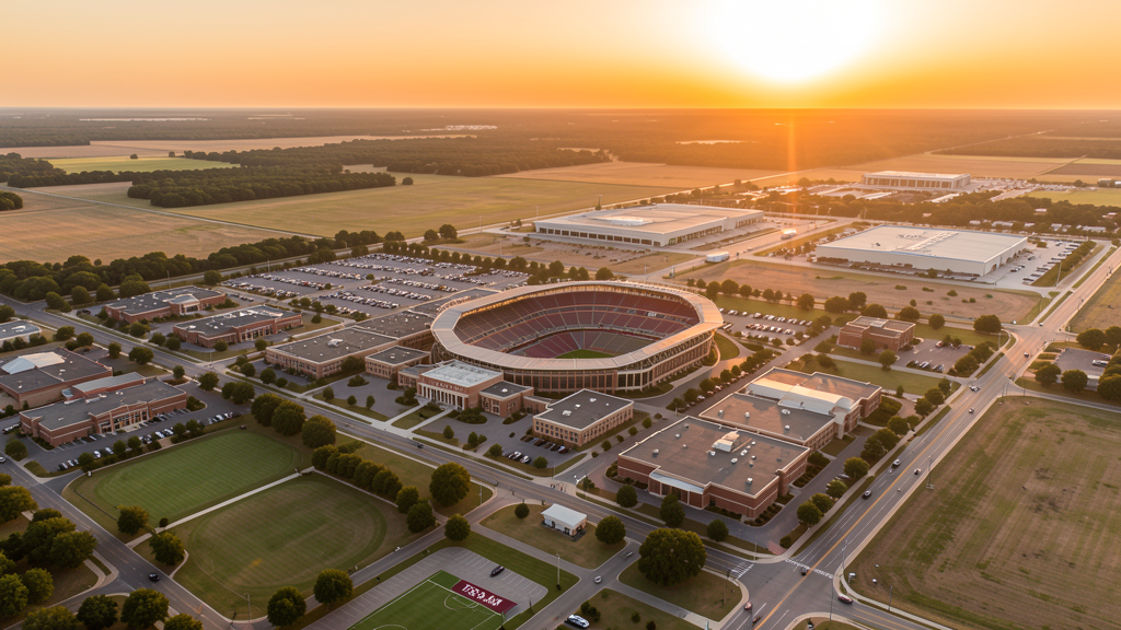
Get Matched With a Local Surveyor
Drone Survey Services Available in College Station, TX
The Bryan-College Station metro is driven by Texas A&M University, the largest university in Texas with 70,000+ students. The university's $4B+ building program, the 2,000-acre RELLIS research campus, the biocorridor biotech district, and continuous student housing construction create year-round survey demand. The CLL Class D airspace covering central College Station and the Kyle Field stadium TFR (110,000+ seats) create significant airspace constraints on football Saturdays. For drone surveyors, the flat terrain and continuous institutional construction make this an efficient and reliable market.
Drone Surveys for College Station's Construction Market
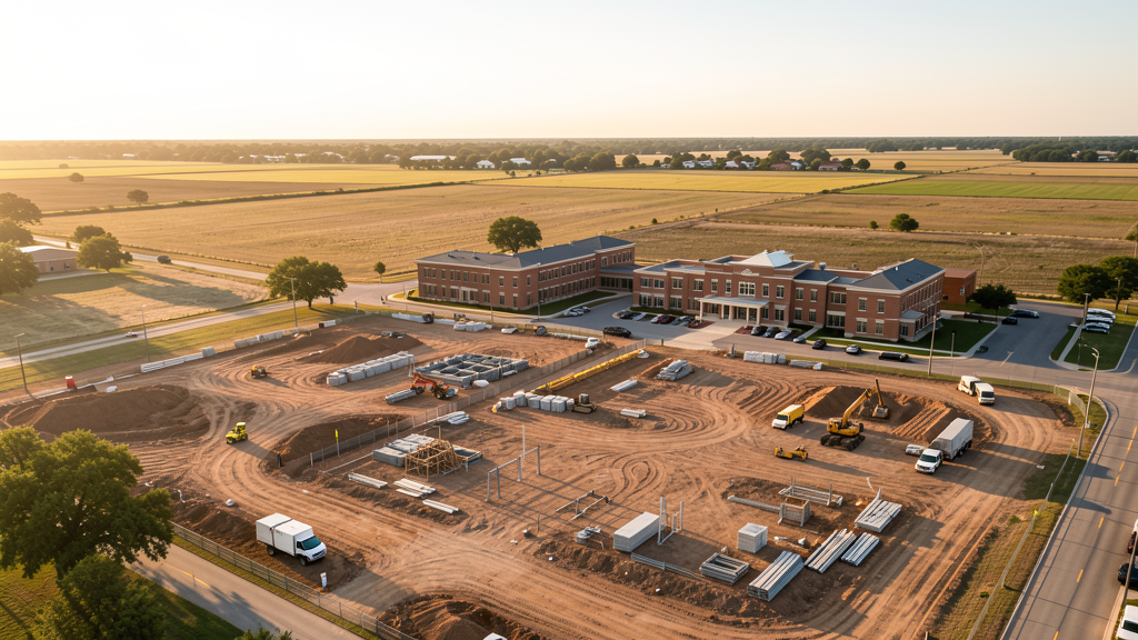
College Station is home to Texas A&M University, the largest university in Texas with 70,000+ students. The university's $4B+ academic building program, including the Interdisciplinary Life Sciences Building, the Engineering Education Complex expansion, and the Zachry Engineering Education Center, drives massive institutional construction. The RELLIS Campus (2,000 acres) is a major research and testing development with autonomous vehicle tracks, drone testing facilities, and defense research buildings. The Bryan-College Station biocorridor along SH 47 includes the National Center for Therapeutics Manufacturing and private biotech companies. Off-campus student housing construction is continuous, with large mixed-use developments along University Drive, Texas Avenue, and Wellborn Road. The Midtown Commons and the Century Square mixed-use developments near the university add retail and residential construction. The SH 6 bypass and the FM 2818 loop expansion generate heavy civil survey demand.
Active Developers in the Area:
Typical Project Costs in Texas
Cost ranges are based on market data for Bryan-College Station. Actual pricing depends on site size, complexity, and deliverables.
| Service Type | Low End | High End |
|---|---|---|
| Topographic Survey | $1,500 | $4,500 |
| Drone Inspection | $200 | $750 |
| LiDAR Scanning | $2,500 | $8,000 |
| Environmental Monitoring | $800 | $3,000 |
| Aerial Imagery | $150 | $450 |
| Construction Monitoring | $850 | $2,500 |
| Real Estate Photography | $150 | $400 |
| Roof Inspection | $175 | $700 |
Local Airspace & Regulations in College Station, TX
FAA Part 107 Requirements
All commercial drone operations in Texas require the pilot to hold an active FAA Part 107 Remote Pilot Certificate. Our network surveyors are verified Part 107 holders.
State Drone Laws
Texas Government Code Chapter 423 restricts drone use over critical infrastructure facilities, including oil and gas pipelines, refineries, power plants, and water treatment facilities. HB 1484 (2023) added protections for agricultural operations and expanded penalties for drone surveillance of private property. Commercial operators must hold a valid FAA Part 107 Remote Pilot Certificate. Texas does not require a separate state drone license, but operators flying near critical infrastructure must obtain authorization from the facility owner. The Texas Department of Public Safety maintains additional guidelines for drone operations near state facilities.
Local Ordinances
College Station does not issue a separate city-level drone permit for commercial operators. FAA Part 107 certification and LAANC authorization for the Easterwood Airport (CLL) Class D zone are the primary requirements. Commercial filming on city property requires a permit through the College Station Parks and Recreation Department. The city prohibits drone takeoff and landing in city parks without a special use permit, including Central Park, Bee Creek Park, and Stephen C. Beachy Central Park. Flights from private property (with owner permission) do not require a city permit but must comply with all FAA Part 107 rules and Texas Government Code Chapter 423 critical infrastructure restrictions. The Texas A&M campus requires coordination with University Police for any drone operations on or over campus property.
Restricted Airspace
- Class D airspace around Easterwood Airport (CLL) — located within College Station city limits on the Texas A&M University campus. Drone flights within 4 nautical miles require LAANC authorization. CLL has commercial airline service (American Airlines to DFW) plus active general aviation and university flight operations. This affects survey work throughout central College Station.
- Texas A&M University campus — the 5,200-acre main campus is one of the largest university campuses in the United States. While not formal restricted airspace, the campus has active security, large outdoor event areas, and sensitive research facilities. Drone flights over the campus should be coordinated with Texas A&M University Police Department. Kyle Field has stadium TFRs during Texas A&M Aggies football games (110,000+ capacity, one of the largest stadiums in the world).
- RELLIS Campus — Texas A&M's 2,000-acre research and testing campus located northwest of the main campus. RELLIS hosts autonomous vehicle testing, drone research facilities, and defense-related research. The campus has restricted airspace for certain testing operations. Always coordinate with RELLIS administration before flying near the campus, as active UAS testing may create airspace conflicts.
- Kyle Field stadium TFRs — during Texas A&M football games, drone flights within 3 nautical miles up to 3,000 ft AGL are prohibited. With a seating capacity of 110,000+, Kyle Field is one of the largest stadiums in the world and generates significant TFR zones. Game day Saturdays in fall are complete no-fly zones for commercial drone operations across most of College Station.
- Biocorridor and research facilities — the Bryan-College Station biocorridor along SH 47 includes the National Center for Therapeutics Manufacturing, the Texas A&M Institute for Genomic Medicine, and private biotech companies. These facilities may have security monitoring and airspace sensitivity. Coordinate with facility management for survey work near biocorridor sites.
- Severe weather: College Station is in the eastern portion of Tornado Alley's southern extent. Spring thunderstorms produce tornadoes, large hail, and flash flooding along the Brazos River. Drone operations during severe weather warnings are restricted. Summer temperatures above 100 degrees Fahrenheit with high humidity reduce drone battery performance significantly.
Airports in the area: undefined (undefined), undefined (undefined), undefined (undefined), undefined (undefined)
Why Hire Through Aerius View in College Station, TX?
FAA-Certified
Every surveyor holds an active Part 107 Remote Pilot Certificate.
Local to College Station
Surveyors who know the Texas airspace and local permitting.
No Cost to Quote
Submit your project at no charge. Pay the surveyor directly if you proceed.
Fast Turnaround
A local surveyor contacts you within 2 business days.
How Our College Station Matching Process Works
We're actively building our network of FAA-certified drone operators in College Station, TX. Here's exactly what happens when you submit a project request.
Submit Your Project
Tell us your site location, acreage, and what you need (topographic survey, LiDAR, inspection, etc.). Takes 60 seconds. No cost, no obligation.
We Match & Vet
We identify Part 107-certified operators in Texas with the right equipment for your project. Every pilot is verified for active certification, insurance, and relevant experience in Texas airspace.
You Get Quotes
Matched surveyors contact you within 2 business days with quotes. You compare pricing, timelines, and deliverables, then choose the right fit. You pay the surveyor directly, no markup.
What Deliverables Do You Get?
Every project includes professional-grade deliverables compatible with standard construction and engineering software:
- Orthomosaic maps (GeoTIFF) for site overview and documentation
- Point clouds (LAS/LAZ) for 3D modeling and volumetric analysis
- DEM/DSM terrain models for cut/fill and grade analysis
- Contour lines (DXF/DWG, CAD-ready) for Civil 3D and Revit
- Progress reports with side-by-side comparisons for construction monitoring
- Coordinate systems matched to your project datum (State Plane, UTM, or local)
Insurance & Liability Protection
Pilot Insurance Required
Every operator in our network must carry active liability insurance. Minimum coverage: $1,000,000 general liability. Proof of insurance is verified before any pilot joins the network.
FAA Part 107 Verified
We confirm each pilot's Remote Pilot Certificate is active and in good standing through the FAA Airmen Inquiry system. Expired certificates are flagged automatically.
Equipment Documentation
Pilots list their drone models, sensors (RGB, LiDAR, thermal, multispectral), and payload specs so we can match the right equipment to your project requirements.
Site Safety Coordination
Pilots coordinate with your site superintendent for safe operations on active construction sites, including flight plans that avoid worker areas and equipment zones.
College Station, TX Drone Survey FAQs
Do I need a permit for a drone survey in College Station?
College Station does not issue a separate city-level drone permit for commercial operators. FAA Part 107 certification is mandatory. LAANC authorization is required for flights within the Easterwood Airport (CLL) Class D zone, which covers central College Station. Drone takeoff and landing in city parks requires a special use permit. For any flights on or over the Texas A&M campus, coordinate with the University Police Department in advance.
How much does a drone survey cost in College Station?
College Station pricing is below the major Texas metros (Houston, DFW, Austin) due to lower overhead. Topographic surveys typically range from $1,500 to $4,500. LiDAR scanning runs $2,500 to $8,000. Roof inspections cost $175 to $700 per building. Construction monitoring is typically $850 to $2,500 per month for recurring flights at university, biocorridor, and residential construction sites.
Can I fly a drone over the Texas A&M campus?
The Texas A&M campus is not formal restricted airspace, but flights over the 5,200-acre campus require coordination with the University Police Department. Kyle Field has stadium TFRs during football games, prohibiting drone flights within 3 nautical miles up to 3,000 ft AGL. With 110,000+ seats, Kyle Field generates one of the largest stadium TFR zones in college football. Game day Saturdays in fall are complete no-fly zones across most of College Station.
What is the RELLIS Campus and how does it affect drone operations?
The RELLIS Campus is Texas A&M's 2,000-acre research and testing facility northwest of the main campus. It hosts autonomous vehicle testing, drone research facilities, and defense-related research. The campus has restricted airspace for certain testing operations, and active UAS testing may create airspace conflicts. Always coordinate with RELLIS administration before flying near the campus. The campus itself is a major customer for survey services, with continuous construction of research buildings and testing infrastructure.
What makes the Bryan-College Station biocorridor significant for drone survey work?
The Bryan-College Station biocorridor along SH 47 is a growing research and manufacturing district anchored by the National Center for Therapeutics Manufacturing, the Texas A&M Institute for Genomic Medicine, and private biotech companies. These facilities require ongoing site survey, construction monitoring, and environmental monitoring services. The biocorridor represents a specialized survey market with higher-value contracts than typical residential work, and the facilities' security requirements mean surveyors must maintain professional coordination protocols.
What makes College Station unique for drone survey work?
College Station is driven by Texas A&M University's $4B+ building program, the 2,000-acre RELLIS research campus, the biocorridor biotech district, and continuous student housing construction. The university creates year-round institutional construction demand that is less cyclical than private development. The CLL Class D airspace covering central College Station means LAANC is frequently required, but the flat terrain makes photogrammetry efficient. The stadium TFR from Kyle Field (110,000+ seats) creates one of the largest no-fly zones in college sports on game days.
Nearby Cities
Are You a Drone Surveyor in College Station?
Get pre-qualified leads in your service area. No membership fees, no monthly minimums. First lead free.
Ready to Start Your Project in College Station, TX?
Get matched with a local, FAA-certified surveyor. No cost, no obligation.
Request a Free Quote