Drone Survey Services in Windsor, CO
Windsor is among northern Colorado fastest-growing communities, with residential subdivisions like RainDance and River Run, the Boardwalk commercial development, and Great Western Industrial Park expansion driving sustained construction survey demand.
Serving Weld County & the Fort Collins-Loveland MSA area
Request a Free Quote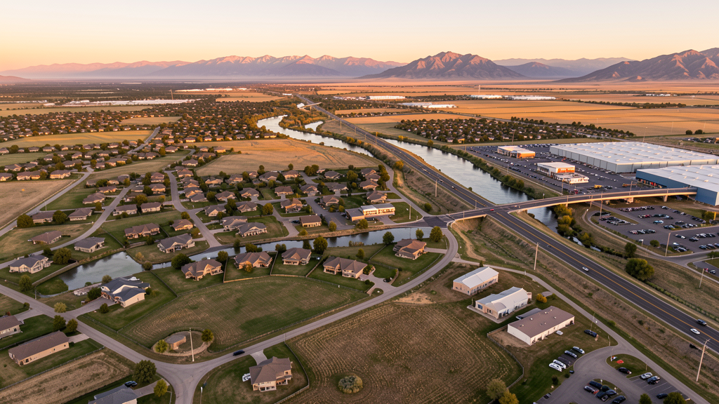
Get Matched With a Local Surveyor
Drone Survey Services Available in Windsor, CO
Windsor sits at the crossroads of the I-25 and US-392 corridors in the booming northern Colorado growth belt between Fort Collins, Loveland, and Greeley. The town has grown from approximately 19,000 in 2010 to over 36,000 by 2024, making it one of the fastest-growing municipalities in the state. This rapid expansion has driven significant infrastructure investment including road widening, water treatment expansion, and new residential and commercial development.
Drone Surveys for Windsor's Construction Market
Windsor is one of the fastest-growing towns in northern Colorado, with an annual growth rate of approximately 5-7% through 2024. Major projects include the Poudre River Trail expansion, the Boardwalk commercial development, and multiple residential subdivisions including RainDance, River Run, and The Preserve at River Valley. Infrastructure spending has accelerated with the widening of Main Street (US Highway 392) and the Eastman Park area development. Corporate and light industrial growth is occurring in the Great Western Industrial Park area.
Active Developers in the Area:

Typical Project Costs in Colorado
Cost ranges are based on market data for Fort Collins-Loveland MSA. Actual pricing depends on site size, complexity, and deliverables.
| Service Type | Low End | High End |
|---|---|---|
| Topographic Survey | $1,400 | $5,500 |
| Drone Inspection | $900 | $4,200 |
| LiDAR Scanning | $3,500 | $10,000 |
| Environmental Monitoring | $1,200 | $5,000 |
| Aerial Imagery | $600 | $2,800 |
| Construction Monitoring | $1,200 | $6,000 |
| Real Estate Photography | $500 | $2,400 |
| Roof Inspection | $400 | $1,900 |
Local Airspace & Regulations in Windsor, CO
FAA Part 107 Requirements
All commercial drone operations in Colorado require the pilot to hold an active FAA Part 107 Remote Pilot Certificate. Our network surveyors are verified Part 107 holders.
State Drone Laws
Colorado HB 1070 (2023) aligns state drone law with federal FAA Part 107 requirements. The law prohibits local municipalities from regulating drone flight paths or airspace, but allows cities to regulate takeoff and landing on public property. Colorado does not require a separate state-level drone license. Commercial drone operators must hold a valid FAA Part 107 Remote Pilot Certificate and comply with all federal regulations. The Colorado Department of Transportation has additional guidelines for drone operations near state highways and infrastructure.
Local Ordinances
Windsor Municipal Code Chapter 6.20 covers parks and recreation with general park rules prohibiting hazardous activities. Drone use in town parks may be restricted under general public safety provisions. Town Code 5.04.010 requires a business license for commercial operators conducting business within Windsor town limits. Commercial filming in Windsor requires a permit from the Town Clerks Office with proof of FAA Part 107 certification and insurance. Windsor does not have a drone-specific ordinance as of early 2025.
Restricted Airspace
- KFNL Class D and KGXY Class D are the primary controlled airspace considerations. Drone operators flying near the KFNL approach path or within 5 NM of either airport at altitudes above the Class D floor need LAANC authorization.
- KDEN Class B outer shelf does not reach Windsor at drone operating altitudes.
- Rocky Mountain National Park (50 miles west) prohibits all drone operations under NPS regulations. Not a direct factor for Windsor but relevant for operators traveling west.
- Natural gas pipelines and electrical transmission corridors near Windsor. Poudre River flood control infrastructure and raw water supply pipelines.
- No permanent TFRs. Temporary TFRs may be issued for wildfire incidents.
Airports in the area: undefined (undefined), undefined (undefined), undefined (undefined), undefined (undefined)
Why Hire Through Aerius View in Windsor, CO?
FAA-Certified
Every surveyor holds an active Part 107 Remote Pilot Certificate.
Local to Windsor
Surveyors who know the Colorado airspace and local permitting.
No Cost to Quote
Submit your project at no charge. Pay the surveyor directly if you proceed.
Fast Turnaround
A local surveyor contacts you within 2 business days.
How Our Windsor Matching Process Works
We're actively building our network of FAA-certified drone operators in Windsor, CO. Here's exactly what happens when you submit a project request.
Submit Your Project
Tell us your site location, acreage, and what you need (topographic survey, LiDAR, inspection, etc.). Takes 60 seconds. No cost, no obligation.
We Match & Vet
We identify Part 107-certified operators in Colorado with the right equipment for your project. Every pilot is verified for active certification, insurance, and relevant experience in Colorado airspace.
You Get Quotes
Matched surveyors contact you within 2 business days with quotes. You compare pricing, timelines, and deliverables, then choose the right fit. You pay the surveyor directly, no markup.
What Deliverables Do You Get?
Every project includes professional-grade deliverables compatible with standard construction and engineering software:
- Orthomosaic maps (GeoTIFF) for site overview and documentation
- Point clouds (LAS/LAZ) for 3D modeling and volumetric analysis
- DEM/DSM terrain models for cut/fill and grade analysis
- Contour lines (DXF/DWG, CAD-ready) for Civil 3D and Revit
- Progress reports with side-by-side comparisons for construction monitoring
- Coordinate systems matched to your project datum (State Plane, UTM, or local)
Insurance & Liability Protection
Pilot Insurance Required
Every operator in our network must carry active liability insurance. Minimum coverage: $1,000,000 general liability. Proof of insurance is verified before any pilot joins the network.
FAA Part 107 Verified
We confirm each pilot's Remote Pilot Certificate is active and in good standing through the FAA Airmen Inquiry system. Expired certificates are flagged automatically.
Equipment Documentation
Pilots list their drone models, sensors (RGB, LiDAR, thermal, multispectral), and payload specs so we can match the right equipment to your project requirements.
Site Safety Coordination
Pilots coordinate with your site superintendent for safe operations on active construction sites, including flight plans that avoid worker areas and equipment zones.
Windsor, CO Drone Survey FAQs
What controlled airspace affects drone operations in Windsor?
Windsor sits between two Class D airports: Northern Colorado Regional Airport (KFNL) approximately 15 miles north and Greeley-Weld County Airport (KGXY) approximately 12 miles southeast. Drone operators flying within 5 nautical miles of either airport need to check whether LAANC authorization is required. Most Windsor city operations at or below 400 ft AGL are outside active Class D surface areas.
Do commercial drone operators need a business license in Windsor?
Yes. Under Town Code 5.04.010, any business operating within Windsor town limits must obtain a business license. Operators must also hold a valid FAA Part 107 Remote Pilot Certificate and provide proof of liability insurance for commercial operations.
What are the main construction projects driving drone survey demand in Windsor?
The Boardwalk commercial development, RainDance and River Run residential subdivisions, Main Street (US-392) widening project, and Great Western Industrial Park expansion are the primary drivers. Windsor is growing at 5-7% annually, one of the fastest rates in northern Colorado, creating sustained demand for topographic, construction progress, and site survey work.
Can drones be flown in Windsor town parks?
Under Chapter 6.20 of the Windsor Municipal Code, drone use is not explicitly banned but may be restricted under general public safety provisions. Operators should avoid flying over populated areas during park events and contact Windsor Parks and Recreation for guidance on specific park locations.
How close is Windsor to restricted National Park airspace?
Rocky Mountain National Park, approximately 50 miles west of Windsor, prohibits all drone operations under National Park Service regulations. While this does not directly affect Windsor city operations, any drone surveys conducted for projects along the US-34 corridor toward Estes Park may need to observe park boundary restrictions.
Nearby Cities
Are You a Drone Surveyor in Windsor?
Get pre-qualified leads in your service area. No membership fees, no monthly minimums. First lead free.
Ready to Start Your Project in Windsor, CO?
Get matched with a local, FAA-certified surveyor. No cost, no obligation.
Request a Free Quote