Drone Survey Services in Post Falls, ID
From the Prairie Crossing mixed-use development at Highway 41 to the I-90 interchange improvement project, Post Falls is growing at 3-4% annually with Spokane-area spillover driving demand for drone topographic and construction monitoring services along the Spokane River corridor.
Serving Kootenai County & the Coeur d'Alene area
Request a Free Quote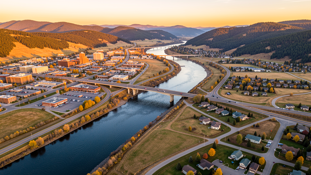
Get Matched With a Local Surveyor
Drone Survey Services Available in Post Falls, ID
Post Falls sits between Coeur d'Alene and Spokane along the I-90 corridor, serving as a rapidly growing bedroom community for both metros. With the Idaho Transportation Department investing $45 million in I-90 interchange improvements and Amazon establishing a fulfillment center in Riverbend Commerce Park, commercial and residential construction is surging. The city position between GEG Class C and SFF Class D airspace means commercial drone operators must carefully plan LAANC authorization for flights in the northern and western areas.
Drone Surveys for Post Falls's Construction Market
Post Falls is one of the fastest-growing cities in North Idaho, with annual growth rates of 3-4% driven by Spokane-area spillover and remote work migration. Major construction includes the Prairie Crossing mixed-use development (300+ acres at Highway 41 and I-90), the Post Falls Landing shopping center expansion, and multiple residential subdivisions along the Spokane River corridor. The Idaho Transportation Department is widening I-90 through Post Falls with a $45 million interchange improvement project. Residential permitting exceeded 500 new housing units in 2023-2024. Amazon operates a fulfillment center in the Riverbend Commerce Park, driving additional commercial development.
Active Developers in the Area:

Typical Project Costs in Idaho
Cost ranges are based on market data for Coeur d'Alene. Actual pricing depends on site size, complexity, and deliverables.
| Service Type | Low End | High End |
|---|---|---|
| Topographic Survey | $1,100 | $4,200 |
| Drone Inspection | $700 | $2,800 |
| LiDAR Scanning | $2,800 | $7,500 |
| Environmental Monitoring | $1,400 | $4,800 |
| Aerial Imagery | $450 | $1,800 |
| Construction Monitoring | $900 | $3,200 |
| Real Estate Photography | $250 | $1,000 |
| Roof Inspection | $350 | $1,400 |
Local Airspace & Regulations in Post Falls, ID
FAA Part 107 Requirements
All commercial drone operations in Idaho require the pilot to hold an active FAA Part 107 Remote Pilot Certificate. Our network surveyors are verified Part 107 holders.
State Drone Laws
Idaho Code § 21-801 et seq (Title 21, Chapter 8) governs unmanned aircraft systems statewide. The law prohibits drone surveillance of private property without consent (§ 21-803, $500 civil penalty per violation), bans weaponization of drones (§ 21-804, misdemeanor), and prohibits using drones to interfere with wildfire suppression (§ 21-805). The state preempts local regulation of drone flight paths and airspace (§ 21-810), though cities may regulate takeoff and landing on public property they own. Idaho does not require a separate state-level drone license. Commercial drone operators must hold a valid FAA Part 107 Remote Pilot Certificate. Idaho was one of the first states to pass comprehensive drone legislation in 2013 (HB 279), amended by SB 1133 (2021) to align definitions with the federal Part 107 framework.
Local Ordinances
Post Falls City Code requires a Special Use Permit for commercial drone operations taking off or landing on city-owned property, including Q'emiln Park, Falls Park, and Black Bay Park. The permit application is processed through Post Falls Parks and Recreation. Flights from private property (with owner permission) do not require a city permit but must comply with FAA Part 107 rules. Idaho Code section 21-810 preempts Post Falls from regulating drone airspace or flight paths. The city nuisance ordinance applies to low-altitude flights over private property on a complaint-driven basis.
Restricted Airspace
- Spokane International Airport (GEG) Class C airspace extends 10 nautical miles, covering the northern Post Falls area. LAANC authorization required for commercial drone flights within the 5 NM inner ring and the 10 NM outer shelf.
- Felts Field (SFF) Class D airspace is located 8 miles northwest in Spokane Valley. The 4 NM ring requires LAANC authorization for commercial drone operations.
- Fairchild Air Force Base (SKA) Class D airspace and Military Operating Area located 20 miles southwest. Active KC-135 tanker training operations. Drone flights in the MOA require coordination with Seattle ARTCC.
- Post Falls City Code prohibits drone takeoff and landing in city parks (Q'emiln Park, Black Bay Park, Falls Park) without a Special Use Permit from Post Falls Parks and Recreation.
- Spokane River corridor through downtown Post Falls has seasonal wildlife restrictions. Operators should avoid disturbing nesting waterfowl along the river during spring months.
- Idaho Panhandle National Forest lands north and east of Post Falls. Seasonal fire TFRs common July through October. Check NOTAMs before flying in forested areas.
Airports in the area: undefined (undefined), undefined (undefined), undefined (undefined), undefined (undefined)
Why Hire Through Aerius View in Post Falls, ID?
FAA-Certified
Every surveyor holds an active Part 107 Remote Pilot Certificate.
Local to Post Falls
Surveyors who know the Idaho airspace and local permitting.
No Cost to Quote
Submit your project at no charge. Pay the surveyor directly if you proceed.
Fast Turnaround
A local surveyor contacts you within 2 business days.
How Our Post Falls Matching Process Works
We're actively building our network of FAA-certified drone operators in Post Falls, ID. Here's exactly what happens when you submit a project request.
Submit Your Project
Tell us your site location, acreage, and what you need (topographic survey, LiDAR, inspection, etc.). Takes 60 seconds. No cost, no obligation.
We Match & Vet
We identify Part 107-certified operators in Idaho with the right equipment for your project. Every pilot is verified for active certification, insurance, and relevant experience in Idaho airspace.
You Get Quotes
Matched surveyors contact you within 2 business days with quotes. You compare pricing, timelines, and deliverables, then choose the right fit. You pay the surveyor directly, no markup.
What Deliverables Do You Get?
Every project includes professional-grade deliverables compatible with standard construction and engineering software:
- Orthomosaic maps (GeoTIFF) for site overview and documentation
- Point clouds (LAS/LAZ) for 3D modeling and volumetric analysis
- DEM/DSM terrain models for cut/fill and grade analysis
- Contour lines (DXF/DWG, CAD-ready) for Civil 3D and Revit
- Progress reports with side-by-side comparisons for construction monitoring
- Coordinate systems matched to your project datum (State Plane, UTM, or local)
Insurance & Liability Protection
Pilot Insurance Required
Every operator in our network must carry active liability insurance. Minimum coverage: $1,000,000 general liability. Proof of insurance is verified before any pilot joins the network.
FAA Part 107 Verified
We confirm each pilot's Remote Pilot Certificate is active and in good standing through the FAA Airmen Inquiry system. Expired certificates are flagged automatically.
Equipment Documentation
Pilots list their drone models, sensors (RGB, LiDAR, thermal, multispectral), and payload specs so we can match the right equipment to your project requirements.
Site Safety Coordination
Pilots coordinate with your site superintendent for safe operations on active construction sites, including flight plans that avoid worker areas and equipment zones.
Post Falls, ID Drone Survey FAQs
Do I need LAANC authorization to fly a drone in Post Falls?
Yes. Northern Post Falls falls within the Spokane International Airport (GEG) Class C airspace 10 NM outer shelf. Flights in controlled airspace require FAA LAANC authorization. Use the Aloft or DroneUp LAANC apps to request instant approval for altitudes up to 400 ft AGL.
Can I fly a drone over Post Falls city parks?
Not without a permit. Post Falls City Code prohibits drone takeoff and landing from city parks, including Q'emiln Park, Falls Park, and Black Bay Park, without a Special Use Permit from Post Falls Parks and Recreation.
How does Mountain Home Air Force Base affect drone flights in the Post Falls area?
Fairchild Air Force Base (SKA) is located 20 miles southwest of Post Falls with an active Class D airspace and Military Operating Area. KC-135 tanker training operations create low-altitude traffic hazards. Check NOTAMs and coordinate with Seattle ARTCC before flying in the MOA.
What construction projects are driving drone survey demand in Post Falls?
The Prairie Crossing mixed-use development, the I-90 interchange improvement project ($45 million), and the Amazon fulfillment center in Riverbend Commerce Park are the primary drivers. Residential permitting exceeded 500 new units in 2023-2024, creating sustained demand for topographic and construction monitoring surveys.
How much does a drone LiDAR survey cost in the Post Falls area?
LiDAR survey pricing in the Coeur d'Alene-Post Falls area ranges from $2,800 to $7,500 depending on acreage, point density requirements, and deliverable complexity. Turnaround is generally 5-10 business days. Standard topographic surveys are less expensive at $1,100 to $4,200.
Nearby Cities
Are You a Drone Surveyor in Post Falls?
Get pre-qualified leads in your service area. No membership fees, no monthly minimums. First lead free.
Ready to Start Your Project in Post Falls, ID?
Get matched with a local, FAA-certified surveyor. No cost, no obligation.
Request a Free Quote