Drone Survey Services in Rathdrum, ID
Growing at 4.5% annually, Rathdrum is the fastest-growing city in Kootenai County with 250+ new housing units permitted in 2023-2024, driven by master-planned communities along Highway 41 and Spokane commuter spillover creating strong demand for drone survey and construction monitoring services.
Serving Kootenai County & the Coeur d'Alene area
Request a Free Quote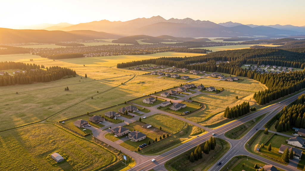
Get Matched With a Local Surveyor
Drone Survey Services Available in Rathdrum, ID
Rathdrum sits on the Rathdrum Prairie in northern Kootenai County, positioned between Coeur d'Alene to the south and the Idaho panhandle forests to the north. The city is the fastest-growing in the county, attracting Spokane commuters and new residents drawn by affordable housing and master-planned communities. The Highway 41 corridor is the primary growth axis, with timber lands surrounding the city creating both unique airspace considerations and seasonal fire TFR risks for drone operators.
Drone Surveys for Rathdrum's Construction Market
Rathdrum is the fastest-growing city in Kootenai County with annual growth rates approaching 4.5%. Major construction includes the Twin Lakes Village expansion, Prairie View subdivision, and commercial development along Highway 41 and Highway 53. The Highway 41 corridor is being widened by the Idaho Transportation Department to handle increased commuter traffic from Spokane. Residential permitting exceeded 250 new housing units in 2023-2024, driven by master-planned community development and Spokane-area spillover.
Active Developers in the Area:

Typical Project Costs in Idaho
Cost ranges are based on market data for Coeur d'Alene. Actual pricing depends on site size, complexity, and deliverables.
| Service Type | Low End | High End |
|---|---|---|
| Topographic Survey | $1,100 | $3,900 |
| Drone Inspection | $700 | $2,700 |
| LiDAR Scanning | $2,500 | $7,200 |
| Environmental Monitoring | $1,200 | $4,400 |
| Aerial Imagery | $400 | $1,600 |
| Construction Monitoring | $850 | $3,100 |
| Real Estate Photography | $250 | $1,000 |
| Roof Inspection | $300 | $1,200 |
Local Airspace & Regulations in Rathdrum, ID
FAA Part 107 Requirements
All commercial drone operations in Idaho require the pilot to hold an active FAA Part 107 Remote Pilot Certificate. Our network surveyors are verified Part 107 holders.
State Drone Laws
Idaho Code § 21-801 et seq (Title 21, Chapter 8) governs unmanned aircraft systems statewide. The law prohibits drone surveillance of private property without consent (§ 21-803, $500 civil penalty per violation), bans weaponization of drones (§ 21-804, misdemeanor), and prohibits using drones to interfere with wildfire suppression (§ 21-805). The state preempts local regulation of drone flight paths and airspace (§ 21-810), though cities may regulate takeoff and landing on public property they own. Idaho does not require a separate state-level drone license. Commercial drone operators must hold a valid FAA Part 107 Remote Pilot Certificate. Idaho was one of the first states to pass comprehensive drone legislation in 2013 (HB 279), amended by SB 1133 (2021) to align definitions with the federal Part 107 framework.
Local Ordinances
Rathdrum does not have a formal drone permitting ordinance. The city requests notification for commercial drone operations in city parks including Majestic Park and Rathdrum City Park. Idaho Code section 21-810 preempts local regulation of drone airspace or flight paths. Flights from private property require owner permission and FAA Part 107 compliance. Timber lands surrounding Rathdrum are managed by Idaho Department of Lands and private companies, requiring landowner permission for operations over those parcels.
Restricted Airspace
- COE Class D airspace extends 4 nautical miles from the airport. Rathdrum is north of the COE Class D shelf and primarily in uncontrolled Class G airspace, but flights south toward Coeur d'Alene may enter controlled airspace requiring LAANC authorization.
- Spokane International Class C airspace (GEG) is 45 miles west. Rathdrum is well outside GEG controlled airspace but check FAA UAS Facility Maps for corridor approaches.
- Rathdrum is surrounded by working timber lands managed by Idaho Department of Lands and private timber companies. Commercial drone operations over active timber lands require permission from the landowner and check for logging operation TFRs.
- Rathdrum City Code does not have specific drone ordinances, but the city requires notification for operations in city parks (Majestic Park, Rathdrum City Park). Idaho Code section 21-810 preempts local airspace regulation.
- Seasonal fire TFRs from July through October affect forest lands surrounding Rathdrum. BLM and Idaho Department of Lands issue fire TFRs that can cover wide areas with no notice.
Airports in the area: undefined (undefined), undefined (undefined), undefined (undefined)
Why Hire Through Aerius View in Rathdrum, ID?
FAA-Certified
Every surveyor holds an active Part 107 Remote Pilot Certificate.
Local to Rathdrum
Surveyors who know the Idaho airspace and local permitting.
No Cost to Quote
Submit your project at no charge. Pay the surveyor directly if you proceed.
Fast Turnaround
A local surveyor contacts you within 2 business days.
How Our Rathdrum Matching Process Works
We're actively building our network of FAA-certified drone operators in Rathdrum, ID. Here's exactly what happens when you submit a project request.
Submit Your Project
Tell us your site location, acreage, and what you need (topographic survey, LiDAR, inspection, etc.). Takes 60 seconds. No cost, no obligation.
We Match & Vet
We identify Part 107-certified operators in Idaho with the right equipment for your project. Every pilot is verified for active certification, insurance, and relevant experience in Idaho airspace.
You Get Quotes
Matched surveyors contact you within 2 business days with quotes. You compare pricing, timelines, and deliverables, then choose the right fit. You pay the surveyor directly, no markup.
What Deliverables Do You Get?
Every project includes professional-grade deliverables compatible with standard construction and engineering software:
- Orthomosaic maps (GeoTIFF) for site overview and documentation
- Point clouds (LAS/LAZ) for 3D modeling and volumetric analysis
- DEM/DSM terrain models for cut/fill and grade analysis
- Contour lines (DXF/DWG, CAD-ready) for Civil 3D and Revit
- Progress reports with side-by-side comparisons for construction monitoring
- Coordinate systems matched to your project datum (State Plane, UTM, or local)
Insurance & Liability Protection
Pilot Insurance Required
Every operator in our network must carry active liability insurance. Minimum coverage: $1,000,000 general liability. Proof of insurance is verified before any pilot joins the network.
FAA Part 107 Verified
We confirm each pilot's Remote Pilot Certificate is active and in good standing through the FAA Airmen Inquiry system. Expired certificates are flagged automatically.
Equipment Documentation
Pilots list their drone models, sensors (RGB, LiDAR, thermal, multispectral), and payload specs so we can match the right equipment to your project requirements.
Site Safety Coordination
Pilots coordinate with your site superintendent for safe operations on active construction sites, including flight plans that avoid worker areas and equipment zones.
Rathdrum, ID Drone Survey FAQs
Do I need LAANC authorization to fly a drone in Rathdrum?
Most of Rathdrum is in uncontrolled Class G airspace and does not require LAANC. However, flights south toward Coeur d'Alene may enter the COE Class D shelf requiring authorization. Check the FAA UAS Facility Map for your specific flight location.
Are there restrictions on flying over timber lands around Rathdrum?
Yes. Timber lands managed by Idaho Department of Lands and private companies require landowner permission for commercial drone operations. Active logging operations may have TFRs. Check with IDL and the landowner before flying.
What is driving the construction boom in Rathdrum?
Rathdrum is the fastest-growing city in Kootenai County at 4.5% annual growth, driven by master-planned communities like Twin Lakes Village and Prairie View, plus Spokane commuter spillover. Over 250 new housing units were permitted in 2023-2024 along the Highway 41 corridor.
Can I fly a drone in Rathdrum city parks?
Rathdrum does not require a formal permit, but the city requests notification for commercial drone operations in Majestic Park and Rathdrum City Park. Contact city hall before flying in parks.
How much does a drone survey cost in Rathdrum?
Topographic surveys in Rathdrum range from $1,100 to $3,900. LiDAR scanning costs $2,500 to $7,200. Construction monitoring runs $850 to $3,100. Turnaround times are 2-10 days depending on service type and acreage.
Nearby Cities
Are You a Drone Surveyor in Rathdrum?
Get pre-qualified leads in your service area. No membership fees, no monthly minimums. First lead free.
Ready to Start Your Project in Rathdrum, ID?
Get matched with a local, FAA-certified surveyor. No cost, no obligation.
Request a Free Quote