Drone Survey Services in Lewisville, TX
From Lake Lewisville waterfront development and the I-35E Express expansion to Castle Hills MPC and Old Town revitalization, Lewisville is a DFW mid-cities hub at the I-35 split where the entire city falls within DFW Class B airspace, making LAANC mandatory for every survey mission.
Serving Denton County & the Dallas-Fort Worth-Arlington area
Request a Free Quote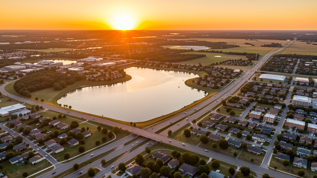
Get Matched With a Local Surveyor
Drone Survey Services Available in Lewisville, TX
Lewisville is a DFW mid-cities hub with 135,000 residents at the I-35E/I-35W split. Lake Lewisville waterfront development, the I-35E Express expansion, and Castle Hills MPC drive construction survey demand. The entire city falls within DFW Class B airspace, making LAANC authorization mandatory for all commercial flights.
Drone Surveys for Lewisville's Construction Market
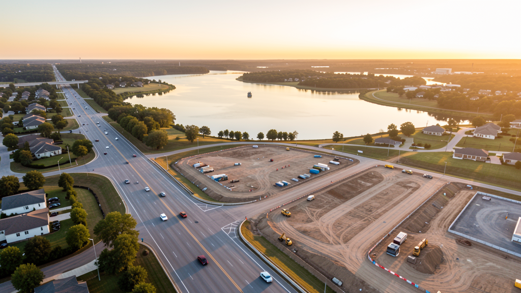
Lewisville is a DFW mid-cities hub at the I-35E and I-35W split, anchored by Lake Lewisville waterfront development, the Vista Ridge Mall redevelopment, and the I-35E expansion. The Old Town Lewisville revitalization, the Castle Hills master-planned community, and the Corporate Drive business park drive mixed-use and commercial construction. The Lake Lewisville waterfront residential and retail development creates unique waterfront survey demand. The I-35E Express expansion and the FM 1171/Main Street improvements generate heavy civil survey work. Lewisville's position at the I-35 split makes it a strategic logistics and distribution location.
Active Developers in the Area:
Typical Project Costs in Texas
Cost ranges are based on market data for Dallas-Fort Worth-Arlington. Actual pricing depends on site size, complexity, and deliverables.
| Service Type | Low End | High End |
|---|---|---|
| Topographic Survey | $1,500 | $4,500 |
| Drone Inspection | $225 | $800 |
| LiDAR Scanning | $2,500 | $8,500 |
| Environmental Monitoring | $800 | $3,200 |
| Aerial Imagery | $150 | $450 |
| Construction Monitoring | $850 | $2,800 |
| Real Estate Photography | $125 | $400 |
| Roof Inspection | $200 | $700 |
Local Airspace & Regulations in Lewisville, TX
FAA Part 107 Requirements
All commercial drone operations in Texas require the pilot to hold an active FAA Part 107 Remote Pilot Certificate. Our network surveyors are verified Part 107 holders.
State Drone Laws
Texas Government Code Chapter 423 restricts drone use over critical infrastructure facilities, including oil and gas pipelines, refineries, power plants, and water treatment facilities. HB 1484 (2023) added protections for agricultural operations and expanded penalties for drone surveillance of private property. Commercial operators must hold a valid FAA Part 107 Remote Pilot Certificate. Texas does not require a separate state drone license, but operators flying near critical infrastructure must obtain authorization from the facility owner. The Texas Department of Public Safety maintains additional guidelines for drone operations near state facilities.
Local Ordinances
Lewisville does not issue a separate city-level drone permit for commercial operators. FAA Part 107 certification and LAANC authorization for DFW Class B airspace are the primary requirements. The entire city falls within DFW Class B, making LAANC mandatory for all commercial flights. Drone takeoff and landing in city parks requires a permit.
Restricted Airspace
- Class B airspace around DFW International — DFW Class B shelves extend directly over Lewisville. LAANC authorization required for ALL commercial drone flights in Lewisville. This is one of the most airspace-restricted cities in the DFW metro.
- Lake Lewisville — large reservoir with active recreational boating. Drone flights over the lake should follow FAA maritime guidelines and avoid interfering with boat traffic. The lake also has USACE infrastructure (dam, spillway) requiring coordination.
- I-35E corridor — active TxDOT expansion projects. Survey flights over highway construction should be coordinated with TxDOT contractors.
- Severe weather: DFW tornado risk zone. Spring thunderstorms produce tornadoes, large hail, and flash flooding. Post-storm roof inspection is a major use case.
Airports in the area: undefined (undefined), undefined (undefined), undefined (undefined)
Why Hire Through Aerius View in Lewisville, TX?
FAA-Certified
Every surveyor holds an active Part 107 Remote Pilot Certificate.
Local to Lewisville
Surveyors who know the Texas airspace and local permitting.
No Cost to Quote
Submit your project at no charge. Pay the surveyor directly if you proceed.
Fast Turnaround
A local surveyor contacts you within 2 business days.
How Our Lewisville Matching Process Works
We're actively building our network of FAA-certified drone operators in Lewisville, TX. Here's exactly what happens when you submit a project request.
Submit Your Project
Tell us your site location, acreage, and what you need (topographic survey, LiDAR, inspection, etc.). Takes 60 seconds. No cost, no obligation.
We Match & Vet
We identify Part 107-certified operators in Texas with the right equipment for your project. Every pilot is verified for active certification, insurance, and relevant experience in Texas airspace.
You Get Quotes
Matched surveyors contact you within 2 business days with quotes. You compare pricing, timelines, and deliverables, then choose the right fit. You pay the surveyor directly, no markup.
What Deliverables Do You Get?
Every project includes professional-grade deliverables compatible with standard construction and engineering software:
- Orthomosaic maps (GeoTIFF) for site overview and documentation
- Point clouds (LAS/LAZ) for 3D modeling and volumetric analysis
- DEM/DSM terrain models for cut/fill and grade analysis
- Contour lines (DXF/DWG, CAD-ready) for Civil 3D and Revit
- Progress reports with side-by-side comparisons for construction monitoring
- Coordinate systems matched to your project datum (State Plane, UTM, or local)
Insurance & Liability Protection
Pilot Insurance Required
Every operator in our network must carry active liability insurance. Minimum coverage: $1,000,000 general liability. Proof of insurance is verified before any pilot joins the network.
FAA Part 107 Verified
We confirm each pilot's Remote Pilot Certificate is active and in good standing through the FAA Airmen Inquiry system. Expired certificates are flagged automatically.
Equipment Documentation
Pilots list their drone models, sensors (RGB, LiDAR, thermal, multispectral), and payload specs so we can match the right equipment to your project requirements.
Site Safety Coordination
Pilots coordinate with your site superintendent for safe operations on active construction sites, including flight plans that avoid worker areas and equipment zones.
Lewisville, TX Drone Survey FAQs
Do I need a permit for a drone survey in Lewisville?
Lewisville does not issue a separate city-level drone permit for commercial operators. FAA Part 107 certification and LAANC authorization for DFW Class B airspace are the primary requirements. The entire city falls within DFW Class B, making LAANC mandatory for all commercial flights. Drone takeoff and landing in city parks requires a permit.
How much does a drone survey cost in Lewisville?
Lewisville pricing reflects the DFW metro market. Topographic surveys typically range from $1,350 to $4,500. LiDAR scanning runs $2,200 to $8,500. Roof inspections cost $175 to $700 per building.
How does DFW Class B airspace affect drone operations in Lewisville?
The entire city of Lewisville falls within DFW Class B airspace shelves. LAANC authorization is required for ALL commercial drone flights. This is one of the most airspace-restricted cities in the DFW metro. Always check FAA UAS Facility Maps for altitude restrictions before scheduling survey flights.
Are there special rules for flying over Lake Lewisville?
Lake Lewisville is a large reservoir with active recreational boating and USACE infrastructure. Drone flights over the lake should follow FAA maritime guidelines and avoid interfering with boat traffic. The dam and spillway infrastructure requires USACE coordination. Waterfront residential and commercial development creates unique waterfront survey demand.
What drives drone survey demand in Lewisville?
The I-35E Express expansion, Lake Lewisville waterfront development, Castle Hills MPC, and Old Town revitalization create diverse construction survey demand. Lewisville's position at the I-35 split makes it a strategic logistics location with warehouse and distribution construction along the highway corridors.
What makes Lewisville unique for drone survey work?
From Lake Lewisville waterfront development and the I-35E Express expansion to Castle Hills MPC and Old Town revitalization, Lewisville is a DFW mid-cities hub at the I-35 split where the entire city falls within DFW Class B airspace, making LAANC mandatory for every survey mission.
Nearby Cities
Are You a Drone Surveyor in Lewisville?
Get pre-qualified leads in your service area. No membership fees, no monthly minimums. First lead free.
Ready to Start Your Project in Lewisville, TX?
Get matched with a local, FAA-certified surveyor. No cost, no obligation.
Request a Free Quote