Drone Survey Services in San Angelo, TX
From Angelo State University campus expansion and Goodfellow AFB military construction to oilfield service facilities and wind farm infrastructure, San Angelo is the regional hub for West Texas oilfield services, wind energy, and military installations.
Serving Tom Green County & the San Angelo area
Request a Free Quote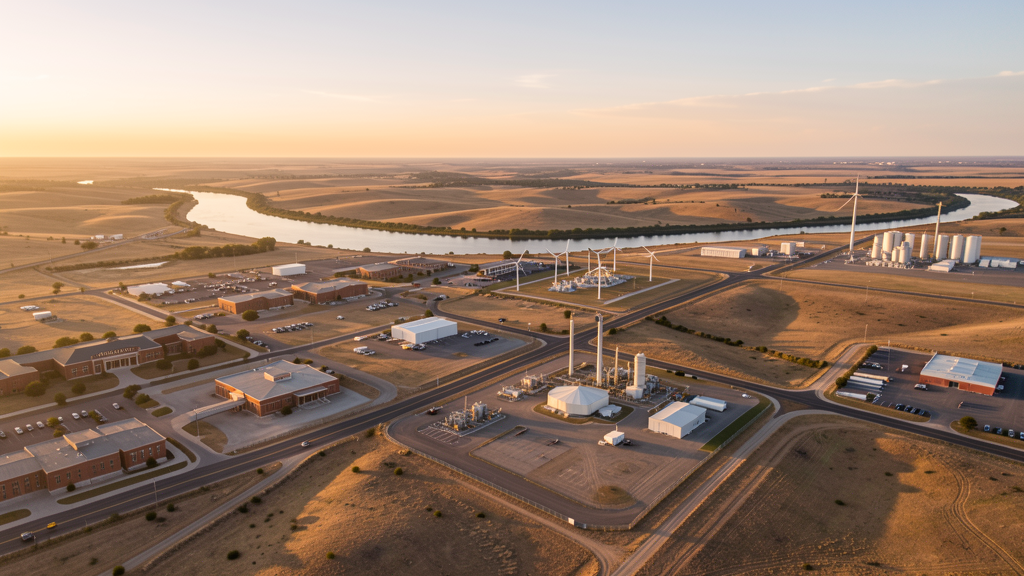
Get Matched With a Local Surveyor
Drone Survey Services Available in San Angelo, TX
San Angelo sits in Tom Green County at the confluence of the North and South Concho Rivers, about 90 miles SW of Abilene. The city has 100,000 residents and serves as the regional hub for West Texas. San Angelo is a service center for the Permian Basin oilfield industry, wind energy development, and agriculture. Goodfellow Air Force Base is adjacent to the city. Angelo State University is a major employer with ongoing campus expansion. The Concho River waterfront development is a mixed-use project in downtown.
Drone Surveys for San Angelo's Construction Market
San Angelo is the regional hub for West Texas, with a population of 100,000. The city serves as a service center for the Permian Basin oilfield industry, wind energy development, and agricultural operations. Major construction includes oilfield service facility expansion, wind farm infrastructure, and the Angelo State University campus growth. The downtown revitalization project and the Concho River waterfront development are mixed-use projects. The city is home to Goodfellow Air Force Base, with ongoing military facility construction. San Angelo has stable population growth driven by the energy sector and the university.
Active Developers in the Area:
Typical Project Costs in Texas
Cost ranges are based on market data for San Angelo. Actual pricing depends on site size, complexity, and deliverables.
| Service Type | Low End | High End |
|---|---|---|
| Topographic Survey | $1,800 | $4,500 |
| Drone Inspection | $250 | $850 |
| LiDAR Scanning | $2,800 | $8,000 |
| Environmental Monitoring | $800 | $3,000 |
| Aerial Imagery | $175 | $500 |
| Construction Monitoring | $1,100 | $3,200 |
| Real Estate Photography | $150 | $450 |
| Roof Inspection | $200 | $750 |
Local Airspace & Regulations in San Angelo, TX
FAA Part 107 Requirements
All commercial drone operations in Texas require the pilot to hold an active FAA Part 107 Remote Pilot Certificate. Our network surveyors are verified Part 107 holders.
State Drone Laws
Texas Government Code Chapter 423 restricts drone use over critical infrastructure facilities, including oil and gas pipelines, refineries, power plants, and water treatment facilities. HB 1484 (2023) added protections for agricultural operations and expanded penalties for drone surveillance of private property. Commercial operators must hold a valid FAA Part 107 Remote Pilot Certificate. Texas does not require a separate state drone license, but operators flying near critical infrastructure must obtain authorization from the facility owner. The Texas Department of Public Safety maintains additional guidelines for drone operations near state facilities.
Local Ordinances
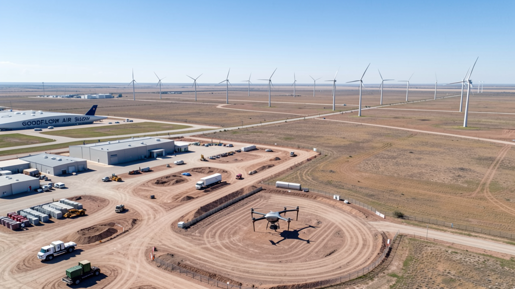
San Angelo follows Tom Green County regulations and FAA Part 107 rules. No city-specific drone permit is required for operations from private property. San Angelo Regional Airport Class D airspace requires LAANC authorization. Goodfellow Air Force Base is adjacent to the city with restricted military airspace requiring coordination. The city prohibits drone takeoff/landing in parks without a permit. San Angelo is the regional hub for West Texas oilfield services, wind energy, and agriculture, with pipeline inspection and infrastructure surveys being primary drone use cases.
Restricted Airspace
- Class D airspace around San Angelo Regional Airport (SJT) — requires LAANC authorization within 4 nautical miles. SJT is 8 miles SE.
- Goodfellow Air Force Base is adjacent to San Angelo with restricted military airspace. Drone flights within 5 miles require coordination with base operations.
- San Angelo city parks prohibit drone takeoff/landing without a special use permit. The Concho River area has recreational traffic.
- Tom Green County has no county-wide drone ordinance, but rural oilfield areas may have advisory zones near infrastructure.
Airports in the area: undefined (undefined), undefined (undefined), undefined (undefined), undefined (undefined)
Why Hire Through Aerius View in San Angelo, TX?
FAA-Certified
Every surveyor holds an active Part 107 Remote Pilot Certificate.
Local to San Angelo
Surveyors who know the Texas airspace and local permitting.
No Cost to Quote
Submit your project at no charge. Pay the surveyor directly if you proceed.
Fast Turnaround
A local surveyor contacts you within 2 business days.
How Our San Angelo Matching Process Works
We're actively building our network of FAA-certified drone operators in San Angelo, TX. Here's exactly what happens when you submit a project request.
Submit Your Project
Tell us your site location, acreage, and what you need (topographic survey, LiDAR, inspection, etc.). Takes 60 seconds. No cost, no obligation.
We Match & Vet
We identify Part 107-certified operators in Texas with the right equipment for your project. Every pilot is verified for active certification, insurance, and relevant experience in Texas airspace.
You Get Quotes
Matched surveyors contact you within 2 business days with quotes. You compare pricing, timelines, and deliverables, then choose the right fit. You pay the surveyor directly, no markup.
What Deliverables Do You Get?
Every project includes professional-grade deliverables compatible with standard construction and engineering software:
- Orthomosaic maps (GeoTIFF) for site overview and documentation
- Point clouds (LAS/LAZ) for 3D modeling and volumetric analysis
- DEM/DSM terrain models for cut/fill and grade analysis
- Contour lines (DXF/DWG, CAD-ready) for Civil 3D and Revit
- Progress reports with side-by-side comparisons for construction monitoring
- Coordinate systems matched to your project datum (State Plane, UTM, or local)
Insurance & Liability Protection
Pilot Insurance Required
Every operator in our network must carry active liability insurance. Minimum coverage: $1,000,000 general liability. Proof of insurance is verified before any pilot joins the network.
FAA Part 107 Verified
We confirm each pilot's Remote Pilot Certificate is active and in good standing through the FAA Airmen Inquiry system. Expired certificates are flagged automatically.
Equipment Documentation
Pilots list their drone models, sensors (RGB, LiDAR, thermal, multispectral), and payload specs so we can match the right equipment to your project requirements.
Site Safety Coordination
Pilots coordinate with your site superintendent for safe operations on active construction sites, including flight plans that avoid worker areas and equipment zones.
San Angelo, TX Drone Survey FAQs
Do I need a permit for a drone survey in San Angelo?
No city-specific permit is required for commercial drone operations from private property in San Angelo. San Angelo Regional Airport Class D airspace requires LAANC authorization. Goodfellow Air Force Base has restricted military airspace requiring coordination. Takeoff/landing in city parks requires a permit. All flights must comply with FAA Part 107 rules.
How much does a drone survey cost in San Angelo, TX?
Topographic surveys in Tom Green County typically range from $1,800 to $4,500. Roof inspections run $200-$750. LiDAR scanning for oilfield or wind energy sites costs $2,800-$8,000. Pipeline inspection services start at $800.
Can I fly a drone near Goodfellow Air Force Base?
Goodfellow Air Force Base is adjacent to San Angelo with restricted military airspace. Drone flights within 5 miles of the base require coordination with base operations. San Angelo Regional Airport Class D airspace also covers the area. Our surveyors handle all military and FAA coordination.
What construction projects need drone surveys in San Angelo?
Angelo State University campus expansion, Goodfellow AFB military construction, oilfield service facility expansion, wind farm infrastructure, Concho River waterfront development, and downtown revitalization all require aerial surveys. San Angelo is the regional hub for West Texas.
How long does a topographic survey take in San Angelo?
A standard 50-acre site can be flown in under an hour. Deliverables including DEM, contour maps, orthomosaic, and point cloud are ready within 3-5 business days. West Texas terrain is flat to rolling with sparse vegetation, ideal for aerial surveys. Wind is a primary scheduling factor in the region.
Nearby Cities
Are You a Drone Surveyor in San Angelo?
Get pre-qualified leads in your service area. No membership fees, no monthly minimums. First lead free.
Ready to Start Your Project in San Angelo, TX?
Get matched with a local, FAA-certified surveyor. No cost, no obligation.
Request a Free Quote