Drone Survey Services in Mountain Home, ID
From the $50+ million Mountain Home AFB facility upgrades to the US-20 corridor improvement project, Mountain Home serves as the primary civilian support community for the 366th Fighter Wing, with military construction and highway investment driving demand for drone survey and inspection services in the Owyhee Mountain corridor.
Serving Elmore County & the Boise City area
Request a Free Quote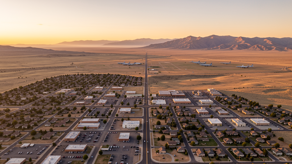
Get Matched With a Local Surveyor
Drone Survey Services Available in Mountain Home, ID
Mountain Home sits along US-20 in Elmore County, serving as the primary civilian support community for Mountain Home Air Force Base and the 366th Fighter Wing. With over $50 million in military construction projects and the Idaho Transportation Department investing $10 million in US-20 improvements, both military and civilian infrastructure construction are active. The city proximity to MUO Class D airspace, surrounding MOAs, and Restricted Area R-4302 means commercial drone operators must carefully plan around active military training schedules and coordinate with Salt Lake City ARTCC for MOA flights.
Drone Surveys for Mountain Home's Construction Market
Mountain Home serves as the Elmore County seat and the primary civilian support community for Mountain Home Air Force Base. Major construction includes the Mountain Home Air Force Base facility upgrades (multiple military construction projects valued at $50+ million), the Mountain Home School District bond projects, and residential development serving both military families and civilian growth. The Idaho Transportation Department is improving US-20 through Mountain Home with a $10 million corridor project. Residential permitting reached approximately 120 new housing units in 2023-2024, with demand driven by military personnel rotations and Boise metro spillover.
Active Developers in the Area:

Typical Project Costs in Idaho
Cost ranges are based on market data for Boise City. Actual pricing depends on site size, complexity, and deliverables.
| Service Type | Low End | High End |
|---|---|---|
| Topographic Survey | $1,000 | $3,800 |
| Drone Inspection | $650 | $2,600 |
| LiDAR Scanning | $2,500 | $6,500 |
| Environmental Monitoring | $1,300 | $4,500 |
| Aerial Imagery | $400 | $1,600 |
| Construction Monitoring | $800 | $3,000 |
| Real Estate Photography | $250 | $900 |
| Roof Inspection | $300 | $1,200 |
Local Airspace & Regulations in Mountain Home, ID
FAA Part 107 Requirements
All commercial drone operations in Idaho require the pilot to hold an active FAA Part 107 Remote Pilot Certificate. Our network surveyors are verified Part 107 holders.
State Drone Laws
Idaho Code § 21-801 et seq (Title 21, Chapter 8) governs unmanned aircraft systems statewide. The law prohibits drone surveillance of private property without consent (§ 21-803, $500 civil penalty per violation), bans weaponization of drones (§ 21-804, misdemeanor), and prohibits using drones to interfere with wildfire suppression (§ 21-805). The state preempts local regulation of drone flight paths and airspace (§ 21-810), though cities may regulate takeoff and landing on public property they own. Idaho does not require a separate state-level drone license. Commercial drone operators must hold a valid FAA Part 107 Remote Pilot Certificate. Idaho was one of the first states to pass comprehensive drone legislation in 2013 (HB 279), amended by SB 1133 (2021) to align definitions with the federal Part 107 framework.
Local Ordinances
Mountain Home City Code requires a Special Use Permit for commercial drone operations taking off or landing on city-owned property, including Richard Aggeler Park and Mountain Home City Park. The permit is processed through Mountain Home Parks and Recreation. Flights from private property (with owner permission) do not require a city permit but must comply with FAA Part 107 rules. Idaho Code section 21-810 preempts Mountain Home from regulating drone airspace or flight paths. Due to the city proximity to Mountain Home AFB Class D airspace and surrounding MOAs, commercial drone operators must check NOTAMs and coordinate with Salt Lake City ARTCC before flying in military training areas.
Restricted Airspace
- Mountain Home Air Force Base (MUO) Class D airspace extends 4 nautical miles from the base. LAANC authorization required for commercial drone flights within this controlled airspace ring. The 366th Fighter Wing operates F-15E Strike Eagle and F-35A Lightning II aircraft with frequent low-altitude training operations.
- Military Operating Areas (MOAs) including Juniper Butte MOA and Saylor Creek MOA surround Mountain Home AFB. Active military training operations with high-speed fighter aircraft. Drone flights in MOA airspace require coordination with Salt Lake City ARTCC. Check NOTAMs for active MOA schedules before any flight.
- Restricted Area R-4302 located south of Mountain Home AFB. Active for military weapons training and bombing range operations. No drone flights permitted within this restricted area under any circumstances.
- Mountain Home City Code prohibits drone takeoff and landing in city parks (Richard Aggeler Park, Mountain Home City Park, Bruneau Dunes State Park access) without a Special Use Permit from Mountain Home Parks and Recreation.
- Owyhee Mountains and BLM-administered lands south and southwest of Mountain Home have seasonal fire restrictions. Summer TFRs for wildfire operations are common July through October.
- Snake River and CJ Strike Reservoir area southeast of Mountain Home has wildlife and recreation restrictions. Operators should avoid disturbing wildlife along the reservoir and river corridor.
Airports in the area: undefined (undefined), undefined (undefined), undefined (undefined), undefined (undefined)
Why Hire Through Aerius View in Mountain Home, ID?
FAA-Certified
Every surveyor holds an active Part 107 Remote Pilot Certificate.
Local to Mountain Home
Surveyors who know the Idaho airspace and local permitting.
No Cost to Quote
Submit your project at no charge. Pay the surveyor directly if you proceed.
Fast Turnaround
A local surveyor contacts you within 2 business days.
How Our Mountain Home Matching Process Works
We're actively building our network of FAA-certified drone operators in Mountain Home, ID. Here's exactly what happens when you submit a project request.
Submit Your Project
Tell us your site location, acreage, and what you need (topographic survey, LiDAR, inspection, etc.). Takes 60 seconds. No cost, no obligation.
We Match & Vet
We identify Part 107-certified operators in Idaho with the right equipment for your project. Every pilot is verified for active certification, insurance, and relevant experience in Idaho airspace.
You Get Quotes
Matched surveyors contact you within 2 business days with quotes. You compare pricing, timelines, and deliverables, then choose the right fit. You pay the surveyor directly, no markup.
What Deliverables Do You Get?
Every project includes professional-grade deliverables compatible with standard construction and engineering software:
- Orthomosaic maps (GeoTIFF) for site overview and documentation
- Point clouds (LAS/LAZ) for 3D modeling and volumetric analysis
- DEM/DSM terrain models for cut/fill and grade analysis
- Contour lines (DXF/DWG, CAD-ready) for Civil 3D and Revit
- Progress reports with side-by-side comparisons for construction monitoring
- Coordinate systems matched to your project datum (State Plane, UTM, or local)
Insurance & Liability Protection
Pilot Insurance Required
Every operator in our network must carry active liability insurance. Minimum coverage: $1,000,000 general liability. Proof of insurance is verified before any pilot joins the network.
FAA Part 107 Verified
We confirm each pilot's Remote Pilot Certificate is active and in good standing through the FAA Airmen Inquiry system. Expired certificates are flagged automatically.
Equipment Documentation
Pilots list their drone models, sensors (RGB, LiDAR, thermal, multispectral), and payload specs so we can match the right equipment to your project requirements.
Site Safety Coordination
Pilots coordinate with your site superintendent for safe operations on active construction sites, including flight plans that avoid worker areas and equipment zones.
Mountain Home, ID Drone Survey FAQs
How does Mountain Home Air Force Base affect drone flights in the area?
Mountain Home AFB (MUO) Class D airspace extends 4 NM from the base, 10 miles southwest of the city. The 366th Fighter Wing operates F-15E and F-35A aircraft with frequent low-altitude training. LAANC authorization is required within the Class D ring. Surrounding MOAs (Juniper Butte, Saylor Creek) and Restricted Area R-4302 require coordination with Salt Lake City ARTCC.
Do I need LAANC authorization to fly a drone in Mountain Home?
The city of Mountain Home itself has Class G airspace around the municipal airport (S72), so LAANC is not required for flights near the city center. However, if your flight extends into the MUO Class D airspace 10 miles southwest, you must obtain LAANC authorization. Always check MOA schedules before flying.
What is Restricted Area R-4302 and can I fly a drone there?
Restricted Area R-4302 is located south of Mountain Home AFB and is active for military weapons training and bombing range operations. No drone flights are permitted within this restricted area under any circumstances. Always check current NOTAMs for active restricted area status.
What construction projects are driving drone survey demand in Mountain Home?
Mountain Home AFB facility upgrades (multiple military construction projects valued at $50+ million), the Mountain Home School District bond projects, and the US-20 corridor improvement project ($10 million) are the primary drivers. Military construction creates sustained demand for progress monitoring and inspection surveys.
How much does a drone LiDAR survey cost in the Mountain Home area?
LiDAR survey pricing in the Elmore County area ranges from $2,500 to $6,500 depending on acreage, point density requirements, and deliverable complexity. Turnaround is generally 5-10 business days. Standard topographic surveys are less expensive at $1,000 to $3,800. Military airspace coordination may add planning time.
Nearby Cities
Are You a Drone Surveyor in Mountain Home?
Get pre-qualified leads in your service area. No membership fees, no monthly minimums. First lead free.
Ready to Start Your Project in Mountain Home, ID?
Get matched with a local, FAA-certified surveyor. No cost, no obligation.
Request a Free Quote