Drone Survey Services in Durango, CO
Durango construction is shaped by constrained mountain valley geography, driving demand for precision survey work on steep terrain sites and the Three Springs mixed-use development while maintaining sensitivity to adjacent federal and tribal lands.
Serving La Plata County & the Durango MSA area
Request a Free Quote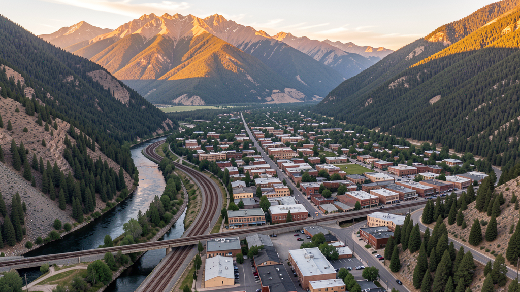
Get Matched With a Local Surveyor
Drone Survey Services Available in Durango, CO
Durango is the commercial and cultural hub of the Four Corners region, with a construction market driven by healthcare expansion, tourism infrastructure, and limited residential infill in the Animas River valley. The city is surrounded by the San Juan National Forest and sits near the Southern Ute Indian Reservation, creating a complex airspace environment requiring careful coordination between FAA, Forest Service, and tribal authorities.
Drone Surveys for Durango's Construction Market
Durango has experienced measured growth at approximately 1.5-2% annually, constrained by mountain valley geography and limited buildable land. Major projects include the Mercy Hospital Durango expansion, continued buildout of the Three Springs mixed-use development on the south side, Fort Lewis College campus improvements, and the City of Durango transit and trail infrastructure investments. The city has also seen significant investment in downtown infrastructure, water system upgrades, and affordable housing initiatives along the Florida Road corridor.
Active Developers in the Area:

Typical Project Costs in Colorado
Cost ranges are based on market data for Durango MSA. Actual pricing depends on site size, complexity, and deliverables.
| Service Type | Low End | High End |
|---|---|---|
| Topographic Survey | $1,400 | $5,000 |
| Drone Inspection | $900 | $3,200 |
| LiDAR Scanning | $2,800 | $8,500 |
| Environmental Monitoring | $1,100 | $3,800 |
| Aerial Imagery | $700 | $2,800 |
| Construction Monitoring | $1,000 | $3,800 |
| Real Estate Photography | $450 | $1,600 |
| Roof Inspection | $550 | $1,900 |
Local Airspace & Regulations in Durango, CO
FAA Part 107 Requirements
All commercial drone operations in Colorado require the pilot to hold an active FAA Part 107 Remote Pilot Certificate. Our network surveyors are verified Part 107 holders.
State Drone Laws
Colorado HB 1070 (2023) aligns state drone law with federal FAA Part 107 requirements. The law prohibits local municipalities from regulating drone flight paths or airspace, but allows cities to regulate takeoff and landing on public property. Colorado does not require a separate state-level drone license. Commercial drone operators must hold a valid FAA Part 107 Remote Pilot Certificate and comply with all federal regulations. The Colorado Department of Transportation has additional guidelines for drone operations near state highways and infrastructure.
Local Ordinances
Durango Municipal Code Chapter 12 regulates activities in city parks; drone operations require permission from the Durango Parks and Recreation Department for commercial activity. Durango Municipal Code Chapter 10 covers offenses and nuisances with privacy provisions applicable to drone operations. Commercial filming permits including drone-based aerial cinematography are issued through the Durango City Managers Office and may involve location fees for city property. La Plata County has no specific drone ordinance but requires commercial operators to observe FAA Part 107 requirements.
Restricted Airspace
- KDRO Class D airspace with a 4-nautical-mile radius surface area extending up to 5,700 feet MSL when the control tower is active. LAANC authorization required. Tower operates seasonally with variable hours; reverts to Class E when closed.
- Mesa Verde National Park (35 miles west) prohibits all drone operations under 36 CFR 1.5. Contains significant archaeological resources with additional federal protections.
- San Juan National Forest surrounds Durango to the north and east; commercial drone operations require a special use permit from the San Juan National Forest office.
- Weminuche Wilderness Area (largest wilderness area in Colorado, north of Durango) prohibits all motorized equipment including drones.
- Southern Ute Indian Reservation (10 miles southeast) requires authorization from the Southern Ute Indian Tribe for drone operations over tribal lands. Tribal airspace sovereignty considerations apply.
- Wildfire TFRs are very common in the San Juan Mountains during summer and fall. The Durango area has been heavily impacted by fires including the 416 Fire (2018).
Airports in the area: undefined (undefined), undefined (undefined)
Why Hire Through Aerius View in Durango, CO?
FAA-Certified
Every surveyor holds an active Part 107 Remote Pilot Certificate.
Local to Durango
Surveyors who know the Colorado airspace and local permitting.
No Cost to Quote
Submit your project at no charge. Pay the surveyor directly if you proceed.
Fast Turnaround
A local surveyor contacts you within 2 business days.
How Our Durango Matching Process Works
We're actively building our network of FAA-certified drone operators in Durango, CO. Here's exactly what happens when you submit a project request.
Submit Your Project
Tell us your site location, acreage, and what you need (topographic survey, LiDAR, inspection, etc.). Takes 60 seconds. No cost, no obligation.
We Match & Vet
We identify Part 107-certified operators in Colorado with the right equipment for your project. Every pilot is verified for active certification, insurance, and relevant experience in Colorado airspace.
You Get Quotes
Matched surveyors contact you within 2 business days with quotes. You compare pricing, timelines, and deliverables, then choose the right fit. You pay the surveyor directly, no markup.
What Deliverables Do You Get?
Every project includes professional-grade deliverables compatible with standard construction and engineering software:
- Orthomosaic maps (GeoTIFF) for site overview and documentation
- Point clouds (LAS/LAZ) for 3D modeling and volumetric analysis
- DEM/DSM terrain models for cut/fill and grade analysis
- Contour lines (DXF/DWG, CAD-ready) for Civil 3D and Revit
- Progress reports with side-by-side comparisons for construction monitoring
- Coordinate systems matched to your project datum (State Plane, UTM, or local)
Insurance & Liability Protection
Pilot Insurance Required
Every operator in our network must carry active liability insurance. Minimum coverage: $1,000,000 general liability. Proof of insurance is verified before any pilot joins the network.
FAA Part 107 Verified
We confirm each pilot's Remote Pilot Certificate is active and in good standing through the FAA Airmen Inquiry system. Expired certificates are flagged automatically.
Equipment Documentation
Pilots list their drone models, sensors (RGB, LiDAR, thermal, multispectral), and payload specs so we can match the right equipment to your project requirements.
Site Safety Coordination
Pilots coordinate with your site superintendent for safe operations on active construction sites, including flight plans that avoid worker areas and equipment zones.
Durango, CO Drone Survey FAQs
What airspace restrictions apply near Durango-La Plata County Airport?
Durango-La Plata County Airport (KDRO) has Class D airspace with a 4-nautical-mile radius surface area extending up to 5,700 feet MSL when the control tower is active. Part 107 pilots must obtain LAANC authorization before operating within this area. The tower operates seasonally with variable hours; when the tower is closed, airspace reverts to Class E. The airport has instrument approaches that create additional considerations for drone operators in the approach corridors.
Can I fly a drone over the Southern Ute Indian Reservation near Durango?
The Southern Ute Indian Reservation is located approximately 10 miles southeast of Durango. Drone operations over tribal lands require authorization from the Southern Ute Indian Tribe through their planning department. Tribal sovereignty means FAA regulations do not automatically supersede tribal authority over their lands. Operators should contact the Southern Ute Tribal Administration building in Ignacio for guidance.
Are there special wildfire TFR considerations for drone operators in the Durango area?
The San Juan Mountains around Durango have experienced significant wildfires including the 416 Fire (2018) which burned over 54,000 acres north of town. Wildfire TFRs are frequently issued during the June-October fire season and can cover large portions of the San Juan National Forest. Drone operators must check FAA TFR listings and NOTAMs before every flight.
Do I need a permit for commercial drone survey work in San Juan National Forest?
Yes, the San Juan National Forest requires commercial drone operators to obtain a special use permit from the San Juan National Forest Supervisor Office in Durango. The permit application involves demonstrating FAA Part 107 certification, insurance, and describing the project scope. Wilderness areas within the forest (Weminuche, South San Juan, Lizard Head) prohibit all drone operations. Permit processing can take 60-90 days.
What are the drone rules for Durango city parks?
Durango Municipal Code Chapter 12 governs parks and recreation, and commercial drone operations in city parks require permission from the Durango Parks and Recreation Department. Parks along the Animas River Trail corridor, including Rotary Park, Schneider Park, and Santa Rita Park, are popular locations where drone activity must be coordinated with park management. Commercial filming permits are processed through the City Managers Office.
Nearby Cities
Are You a Drone Surveyor in Durango?
Get pre-qualified leads in your service area. No membership fees, no monthly minimums. First lead free.
Ready to Start Your Project in Durango, CO?
Get matched with a local, FAA-certified surveyor. No cost, no obligation.
Request a Free Quote