Drone Survey Services in Dacono, CO
Dacono is positioned in the fast-growing Carbon Valley submarket with active residential subdivisions from national homebuilders like DR Horton and Lennar, plus ongoing oil and gas infrastructure projects driving steady construction survey demand.
Serving Weld County & the Denver-Aurora-Lakewood MSA area
Request a Free Quote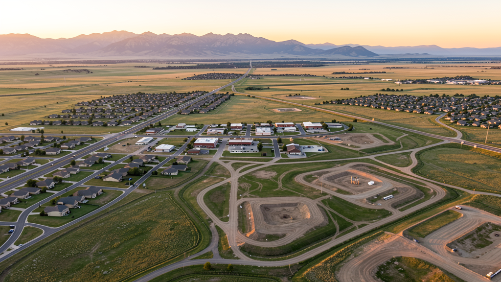
Get Matched With a Local Surveyor
Drone Survey Services Available in Dacono, CO
Dacono is the southern anchor of the Carbon Valley submarket along the I-25 corridor between Denver and Fort Collins. The city has grown from approximately 4,500 in 2010 to over 8,000 by 2024, riding the wave of northward Denver metro expansion. The combination of residential subdivision development from national homebuilders and ongoing oil and gas infrastructure investment in southwestern Weld County creates a dual-market demand for drone survey services.
Drone Surveys for Dacono's Construction Market
Dacono is experiencing rapid residential growth as part of the North I-25 corridor expansion zone, with an annual growth rate of approximately 4-6% through 2024. The city is positioned in the Carbon Valley submarket, which includes Dacono, Frederick, and Firestone. Major residential developments include the Grand View subdivision expansion and the Carbon Valley Regional Park area development. Infrastructure spending has focused on the I-25 frontage road improvements and the Carbon Valley water infrastructure upgrades. Light industrial and commercial development is occurring along the US-52 corridor.
Active Developers in the Area:

Typical Project Costs in Colorado
Cost ranges are based on market data for Denver-Aurora-Lakewood MSA. Actual pricing depends on site size, complexity, and deliverables.
| Service Type | Low End | High End |
|---|---|---|
| Topographic Survey | $1,200 | $4,800 |
| Drone Inspection | $800 | $3,500 |
| LiDAR Scanning | $3,000 | $9,000 |
| Environmental Monitoring | $1,000 | $4,500 |
| Aerial Imagery | $500 | $2,200 |
| Construction Monitoring | $1,000 | $5,500 |
| Real Estate Photography | $400 | $2,000 |
| Roof Inspection | $350 | $1,800 |
Local Airspace & Regulations in Dacono, CO
FAA Part 107 Requirements
All commercial drone operations in Colorado require the pilot to hold an active FAA Part 107 Remote Pilot Certificate. Our network surveyors are verified Part 107 holders.
State Drone Laws
Colorado HB 1070 (2023) aligns state drone law with federal FAA Part 107 requirements. The law prohibits local municipalities from regulating drone flight paths or airspace, but allows cities to regulate takeoff and landing on public property. Colorado does not require a separate state-level drone license. Commercial drone operators must hold a valid FAA Part 107 Remote Pilot Certificate and comply with all federal regulations. The Colorado Department of Transportation has additional guidelines for drone operations near state highways and infrastructure.
Local Ordinances
Dacono Municipal Code Chapter 11 covers parks and recreation with general park rules prohibiting activities that create a public nuisance or hazard. Drone operations in city parks may be subject to these general provisions. City Code 9.20 covers nuisances and could apply to drone operations creating unreasonable noise or disturbance. Commercial filming and photography in Dacono requires coordination with City Hall. City Code Chapter 5.04 requires a business license for commercial operations within city limits.
Restricted Airspace
- Dacono falls within the 30-nautical-mile Mode C veil around Denver International Airport. While Class B surface-area floors typically start at 8,000-10,000 ft MSL (well above drone operating altitudes of 400 ft AGL), operators must be aware of the Mode C transponder requirement for manned aircraft in this area.
- KLMO (Vance Brand/Longmont) Class D is approximately 10 miles northwest. KGXY (Greeley-Weld) Class D is 20 miles northeast. Neither directly overlays Dacono.
- Oil and gas corridor of southwestern Weld County with numerous active natural gas wells, pipelines, and processing facilities. The Tri-State Generation and Transmission Association power infrastructure and historical coal mine operations are present.
- No national parks nearby. Rocky Mountain National Park is approximately 45 miles northwest and prohibits drones.
- No permanent TFRs. Temporary TFRs may be issued for wildfire incidents and VIP movements.
Airports in the area: undefined (undefined), undefined (undefined), undefined (undefined), undefined (undefined)
Why Hire Through Aerius View in Dacono, CO?
FAA-Certified
Every surveyor holds an active Part 107 Remote Pilot Certificate.
Local to Dacono
Surveyors who know the Colorado airspace and local permitting.
No Cost to Quote
Submit your project at no charge. Pay the surveyor directly if you proceed.
Fast Turnaround
A local surveyor contacts you within 2 business days.
How Our Dacono Matching Process Works
We're actively building our network of FAA-certified drone operators in Dacono, CO. Here's exactly what happens when you submit a project request.
Submit Your Project
Tell us your site location, acreage, and what you need (topographic survey, LiDAR, inspection, etc.). Takes 60 seconds. No cost, no obligation.
We Match & Vet
We identify Part 107-certified operators in Colorado with the right equipment for your project. Every pilot is verified for active certification, insurance, and relevant experience in Colorado airspace.
You Get Quotes
Matched surveyors contact you within 2 business days with quotes. You compare pricing, timelines, and deliverables, then choose the right fit. You pay the surveyor directly, no markup.
What Deliverables Do You Get?
Every project includes professional-grade deliverables compatible with standard construction and engineering software:
- Orthomosaic maps (GeoTIFF) for site overview and documentation
- Point clouds (LAS/LAZ) for 3D modeling and volumetric analysis
- DEM/DSM terrain models for cut/fill and grade analysis
- Contour lines (DXF/DWG, CAD-ready) for Civil 3D and Revit
- Progress reports with side-by-side comparisons for construction monitoring
- Coordinate systems matched to your project datum (State Plane, UTM, or local)
Insurance & Liability Protection
Pilot Insurance Required
Every operator in our network must carry active liability insurance. Minimum coverage: $1,000,000 general liability. Proof of insurance is verified before any pilot joins the network.
FAA Part 107 Verified
We confirm each pilot's Remote Pilot Certificate is active and in good standing through the FAA Airmen Inquiry system. Expired certificates are flagged automatically.
Equipment Documentation
Pilots list their drone models, sensors (RGB, LiDAR, thermal, multispectral), and payload specs so we can match the right equipment to your project requirements.
Site Safety Coordination
Pilots coordinate with your site superintendent for safe operations on active construction sites, including flight plans that avoid worker areas and equipment zones.
Dacono, CO Drone Survey FAQs
Does the Denver International Airport Class B airspace affect drone flights in Dacono?
Dacono falls within the 30-nautical-mile Mode C veil around Denver International Airport (KDEN). While the Class B surface-area floors in this region typically start at 8,000-10,000 ft MSL (well above standard drone operating altitudes of 400 ft AGL), operators must be aware of the Mode C transponder requirement for manned aircraft. Drone operations at or below 400 ft AGL in Class E airspace under the Class B shelf do not require specific Class B authorization.
What should drone operators know about oil and gas infrastructure in Dacono?
Dacono sits in the active oil and gas corridor of southwestern Weld County. Numerous natural gas wells, pipelines, and processing facilities are in the area. While there are no FAA restricted areas specifically for oil and gas facilities, operators should observe facility security perimeters, avoid flying directly over active well sites without permission, and coordinate with site operators for any inspection work.
Do commercial drone operators need a business license in Dacono?
Yes. Under City Code Chapter 5.04, commercial businesses operating within Dacono city limits must obtain a business license. Drone operators must also hold a valid FAA Part 107 Remote Pilot Certificate and carry appropriate liability insurance for commercial operations.
What controlled airspace is nearest to Dacono?
The nearest controlled airspace (Class D) is Vance Brand Municipal Airport (KLMO) in Longmont, approximately 10 miles northwest, and Erie Municipal Airport approximately 8 miles southwest in Class E. Most Dacono operations are in uncontrolled Class E airspace. Operators should check the KDEN Class B Mode C veil boundaries to ensure compliance.
What residential development projects are driving drone survey demand in Dacono?
Dacono is part of the rapidly growing Carbon Valley submarket, with national homebuilders including DR Horton, Lennar, Richmond American Homes, and KB Home actively developing residential subdivisions. The Grand View subdivision expansion and infrastructure projects along the US-52 corridor and I-25 frontage road are the primary drivers of demand for topographic, construction progress, and site survey drone services.
Nearby Cities
Are You a Drone Surveyor in Dacono?
Get pre-qualified leads in your service area. No membership fees, no monthly minimums. First lead free.
Ready to Start Your Project in Dacono, CO?
Get matched with a local, FAA-certified surveyor. No cost, no obligation.
Request a Free Quote