Drone Survey Services in Blackfoot, ID
From the Gem State Processing facility expansion to the Blackfoot School District bond projects, this Bingham County seat is investing $12 million in US-91 corridor improvements while serving as the potato industry hub for eastern Idaho, driving demand for agricultural and infrastructure drone survey services.
Serving Bingham County & the Pocatello-Blackfoot area
Request a Free Quote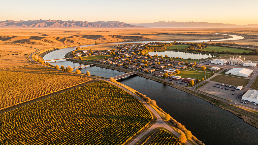
Get Matched With a Local Surveyor
Drone Survey Services Available in Blackfoot, ID
Blackfoot sits along the Snake River in eastern Idaho, serving as the Bingham County seat and a regional agricultural processing center. With the Idaho Transportation Department investing $12 million in US-91 improvements and major potato processing facilities expanding, both infrastructure and agricultural construction are active. The city proximity to INL restricted airspace and Fort Hall Indian Reservation means commercial drone operators must carefully plan flight paths to avoid prohibited zones.
Drone Surveys for Blackfoot's Construction Market
Blackfoot serves as the Bingham County seat and a regional agricultural processing hub, home to the Idaho Potato Museum and major potato processing facilities. Major construction includes the Gem State Processing facility expansion, the Blackfoot School District bond projects (new high school wing and intermediate school upgrades), and residential development along the Snake River bench. The Idaho Transportation Department is improving US-91 through Blackfoot with a $12 million corridor project. Residential permitting reached approximately 120 new housing units in 2023-2024.
Active Developers in the Area:

Typical Project Costs in Idaho
Cost ranges are based on market data for Pocatello-Blackfoot. Actual pricing depends on site size, complexity, and deliverables.
| Service Type | Low End | High End |
|---|---|---|
| Topographic Survey | $950 | $3,500 |
| Drone Inspection | $600 | $2,300 |
| LiDAR Scanning | $2,300 | $6,000 |
| Environmental Monitoring | $1,200 | $4,200 |
| Aerial Imagery | $350 | $1,500 |
| Construction Monitoring | $750 | $2,800 |
| Real Estate Photography | $200 | $800 |
| Roof Inspection | $250 | $1,100 |
Local Airspace & Regulations in Blackfoot, ID
FAA Part 107 Requirements
All commercial drone operations in Idaho require the pilot to hold an active FAA Part 107 Remote Pilot Certificate. Our network surveyors are verified Part 107 holders.
State Drone Laws
Idaho Code § 21-801 et seq (Title 21, Chapter 8) governs unmanned aircraft systems statewide. The law prohibits drone surveillance of private property without consent (§ 21-803, $500 civil penalty per violation), bans weaponization of drones (§ 21-804, misdemeanor), and prohibits using drones to interfere with wildfire suppression (§ 21-805). The state preempts local regulation of drone flight paths and airspace (§ 21-810), though cities may regulate takeoff and landing on public property they own. Idaho does not require a separate state-level drone license. Commercial drone operators must hold a valid FAA Part 107 Remote Pilot Certificate. Idaho was one of the first states to pass comprehensive drone legislation in 2013 (HB 279), amended by SB 1133 (2021) to align definitions with the federal Part 107 framework.
Local Ordinances
Blackfoot City Code requires a Special Use Permit for commercial drone operations taking off or landing on city-owned property, including Jensen Grove Park and Lion's Park. The permit is processed through Blackfoot Parks and Recreation. Flights from private property (with owner permission) do not require a city permit but must comply with FAA Part 107 rules. Idaho Code section 21-810 preempts Blackfoot from regulating drone airspace or flight paths. Operators should be aware that Fort Hall Indian Reservation borders the city to the west and requires tribal permits for drone operations over reservation lands.
Restricted Airspace
- Idaho National Laboratory (INL) restricted airspace located 25 miles northwest. Prohibited Area P-462 and Restricted Areas R-4601, R-4602, R-4603 are active for nuclear research facility security. No drone flights permitted within these zones under any circumstances.
- Blackfoot Airport (U60) is an untowered GA airport with Class G airspace. While LAANC is not required, operators must maintain visual line of sight and yield to manned aircraft. Use CTAF frequency 122.8 to announce intentions.
- Fort Hall Indian Reservation borders Blackfoot to the west. Tribal lands require a permit from the Shoshone-Bannock Tribes for commercial drone operations. Unauthorized flights over reservation lands may result in tribal law enforcement action.
- Blackfoot City Code prohibits drone takeoff and landing in city parks (Jensen Grove Park, Riviera Golf Course area, Lion's Park) without a Special Use Permit from Blackfoot Parks and Recreation.
- Snake River corridor and Jensen Grove reservoir have seasonal wildlife restrictions. Operators should avoid disturbing waterfowl during spring migration and nesting seasons.
- Bingham County has seasonal fire restrictions on agricultural and BLM lands. Summer TFRs for wildfire operations and agricultural burning are common July through October.
Airports in the area: undefined (undefined), undefined (undefined), undefined (undefined), undefined (undefined)
Why Hire Through Aerius View in Blackfoot, ID?
FAA-Certified
Every surveyor holds an active Part 107 Remote Pilot Certificate.
Local to Blackfoot
Surveyors who know the Idaho airspace and local permitting.
No Cost to Quote
Submit your project at no charge. Pay the surveyor directly if you proceed.
Fast Turnaround
A local surveyor contacts you within 2 business days.
How Our Blackfoot Matching Process Works
We're actively building our network of FAA-certified drone operators in Blackfoot, ID. Here's exactly what happens when you submit a project request.
Submit Your Project
Tell us your site location, acreage, and what you need (topographic survey, LiDAR, inspection, etc.). Takes 60 seconds. No cost, no obligation.
We Match & Vet
We identify Part 107-certified operators in Idaho with the right equipment for your project. Every pilot is verified for active certification, insurance, and relevant experience in Idaho airspace.
You Get Quotes
Matched surveyors contact you within 2 business days with quotes. You compare pricing, timelines, and deliverables, then choose the right fit. You pay the surveyor directly, no markup.
What Deliverables Do You Get?
Every project includes professional-grade deliverables compatible with standard construction and engineering software:
- Orthomosaic maps (GeoTIFF) for site overview and documentation
- Point clouds (LAS/LAZ) for 3D modeling and volumetric analysis
- DEM/DSM terrain models for cut/fill and grade analysis
- Contour lines (DXF/DWG, CAD-ready) for Civil 3D and Revit
- Progress reports with side-by-side comparisons for construction monitoring
- Coordinate systems matched to your project datum (State Plane, UTM, or local)
Insurance & Liability Protection
Pilot Insurance Required
Every operator in our network must carry active liability insurance. Minimum coverage: $1,000,000 general liability. Proof of insurance is verified before any pilot joins the network.
FAA Part 107 Verified
We confirm each pilot's Remote Pilot Certificate is active and in good standing through the FAA Airmen Inquiry system. Expired certificates are flagged automatically.
Equipment Documentation
Pilots list their drone models, sensors (RGB, LiDAR, thermal, multispectral), and payload specs so we can match the right equipment to your project requirements.
Site Safety Coordination
Pilots coordinate with your site superintendent for safe operations on active construction sites, including flight plans that avoid worker areas and equipment zones.
Blackfoot, ID Drone Survey FAQs
How does the Idaho National Laboratory affect drone flights near Blackfoot?
The INL restricted airspace (Prohibited Area P-462, Restricted Areas R-4601-4603) is located 25 miles northwest of Blackfoot. No drone flights are permitted within these zones under any circumstances. The prohibited area is active at all times for nuclear research facility security.
Do I need LAANC authorization to fly a drone in Blackfoot?
Blackfoot Airport (U60) has Class G (uncontrolled) airspace, so LAANC is not required for flights near the airport. However, if your flight extends into the PIH Class D airspace 25 miles south or IDA Class D 25 miles north, you will need LAANC authorization for those zones.
Can I fly a drone over Fort Hall Indian Reservation near Blackfoot?
Not without a tribal permit. Fort Hall Indian Reservation borders Blackfoot to the west. The Shoshone-Bannock Tribes require a permit for commercial drone operations over reservation lands. Unauthorized flights may result in tribal law enforcement action.
What construction projects are driving drone survey demand in Blackfoot?
The Gem State Processing facility expansion, Blackfoot School District bond projects, and the US-91 corridor improvement project ($12 million) are the primary drivers. Agricultural processing facility inspections create recurring commercial drone demand.
How much does a drone LiDAR survey cost in the Blackfoot area?
LiDAR survey pricing in the Bingham County area ranges from $2,300 to $6,000 depending on acreage, point density requirements, and deliverable complexity. Turnaround is generally 5-10 business days. Standard topographic surveys are less expensive at $950 to $3,500.
Nearby Cities
Are You a Drone Surveyor in Blackfoot?
Get pre-qualified leads in your service area. No membership fees, no monthly minimums. First lead free.
Ready to Start Your Project in Blackfoot, ID?
Get matched with a local, FAA-certified surveyor. No cost, no obligation.
Request a Free Quote