Drone Survey Services in Idaho Falls, ID
Idaho Falls construction market is driven by the $80M Mountain View Hospital expansion, the 400+ acre Snake River Landing mixed-use development, and ongoing INL facility upgrades creating sustained demand for topographic and environmental drone surveys in eastern Idaho.
Serving Bonneville County & the Idaho Falls area
Request a Free Quote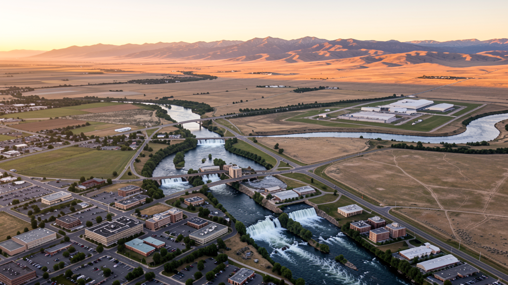
Get Matched With a Local Surveyor
Drone Survey Services Available in Idaho Falls, ID
Idaho Falls is the second-largest metropolitan area in Idaho and the regional hub for eastern Idaho healthcare, energy, and defense industries. The city proximity to the Idaho National Laboratory creates unique airspace restrictions, including Prohibited Area P-462 and Restricted Areas R-4601 through R-4603. Construction activity is robust, with the Snake River Landing development, hospital expansions, and transportation infrastructure projects driving steady demand for drone survey and inspection services across multiple sectors.
Drone Surveys for Idaho Falls's Construction Market
Idaho Falls is the second-largest metro area in Idaho, with construction driven by growth in healthcare, energy, and defense sectors. The $80M Mountain View Hospital expansion and Idaho National Laboratory facility upgrades are major projects. The city approved $45M in building permits in 2023, including the Snake River Landing mixed-use development. The I-15 Broadway Interchange reconstruction ($25M ITD project) and the Utah Avenue revitalization are ongoing. Data center development near the INL buffer zone is creating new demand for site survey work.
Active Developers in the Area:

Typical Project Costs in Idaho
Cost ranges are based on market data for Idaho Falls. Actual pricing depends on site size, complexity, and deliverables.
| Service Type | Low End | High End |
|---|---|---|
| Topographic Survey | $1,500 | $4,500 |
| Drone Inspection | $1,000 | $3,200 |
| LiDAR Scanning | $2,500 | $7,500 |
| Environmental Monitoring | $1,300 | $4,800 |
| Aerial Imagery | $450 | $1,600 |
| Construction Monitoring | $1,100 | $3,900 |
| Real Estate Photography | $350 | $1,300 |
| Roof Inspection | $300 | $1,000 |
Local Airspace & Regulations in Idaho Falls, ID
FAA Part 107 Requirements
All commercial drone operations in Idaho require the pilot to hold an active FAA Part 107 Remote Pilot Certificate. Our network surveyors are verified Part 107 holders.
State Drone Laws
Idaho Code § 21-801 et seq (Title 21, Chapter 8) governs unmanned aircraft systems statewide. The law prohibits drone surveillance of private property without consent (§ 21-803, $500 civil penalty per violation), bans weaponization of drones (§ 21-804, misdemeanor), and prohibits using drones to interfere with wildfire suppression (§ 21-805). The state preempts local regulation of drone flight paths and airspace (§ 21-810), though cities may regulate takeoff and landing on public property they own. Idaho does not require a separate state-level drone license. Commercial drone operators must hold a valid FAA Part 107 Remote Pilot Certificate. Idaho was one of the first states to pass comprehensive drone legislation in 2013 (HB 279), amended by SB 1133 (2021) to align definitions with the federal Part 107 framework.
Local Ordinances
Idaho Falls does not have a standalone drone ordinance. Operations must comply with Idaho Code section 21-801 et seq. Idaho Falls Parks and Recreation requires a permit for drone flights in city parks including the Snake River Greenbelt, Freeman Park, and Tautphaus Park. Flights near Eastern Idaho Regional Medical Center and Idaho Falls School District 91 properties should be coordinated with facility security. The city proximity to INL restricted airspace requires all operators to verify NOTAMs before flying west of the city.
Restricted Airspace
- Class D airspace around Idaho Falls Regional Airport (IDA), 5 NM radius from surface to 7,000 ft MSL. LAANC authorization required for drone operations within this area.
- Idaho National Laboratory (INL) restricted airspace, 30 miles west. Includes Prohibited Area P-462 and Restricted Areas R-4601, R-4602, R-4603. Drone flights strictly prohibited without DOE authorization. Violations can result in serious federal consequences due to the nuclear research nature of the facility.
- INL Site Survey Areas with additional FAA restrictions surrounding the INL complex. Drone operators must check NOTAMs before flying west of the city.
- Caribou-Targhee National Forest east of Idaho Falls. Seasonal TFRs during wildfire season (June through October).
- Yellowstone National Park approximately 100 miles northeast has a standing drone prohibition. Flights near the western approach corridor may trigger advisories.
- Idaho Falls Parks and Recreation requires a permit for drone flights in city parks including the Snake River Greenbelt, Freeman Park, and Tautphaus Park.
Airports in the area: undefined (undefined), undefined (undefined), undefined (undefined), undefined (undefined)
Why Hire Through Aerius View in Idaho Falls, ID?
FAA-Certified
Every surveyor holds an active Part 107 Remote Pilot Certificate.
Local to Idaho Falls
Surveyors who know the Idaho airspace and local permitting.
No Cost to Quote
Submit your project at no charge. Pay the surveyor directly if you proceed.
Fast Turnaround
A local surveyor contacts you within 2 business days.
How Our Idaho Falls Matching Process Works
We're actively building our network of FAA-certified drone operators in Idaho Falls, ID. Here's exactly what happens when you submit a project request.
Submit Your Project
Tell us your site location, acreage, and what you need (topographic survey, LiDAR, inspection, etc.). Takes 60 seconds. No cost, no obligation.
We Match & Vet
We identify Part 107-certified operators in Idaho with the right equipment for your project. Every pilot is verified for active certification, insurance, and relevant experience in Idaho airspace.
You Get Quotes
Matched surveyors contact you within 2 business days with quotes. You compare pricing, timelines, and deliverables, then choose the right fit. You pay the surveyor directly, no markup.
What Deliverables Do You Get?
Every project includes professional-grade deliverables compatible with standard construction and engineering software:
- Orthomosaic maps (GeoTIFF) for site overview and documentation
- Point clouds (LAS/LAZ) for 3D modeling and volumetric analysis
- DEM/DSM terrain models for cut/fill and grade analysis
- Contour lines (DXF/DWG, CAD-ready) for Civil 3D and Revit
- Progress reports with side-by-side comparisons for construction monitoring
- Coordinate systems matched to your project datum (State Plane, UTM, or local)
Insurance & Liability Protection
Pilot Insurance Required
Every operator in our network must carry active liability insurance. Minimum coverage: $1,000,000 general liability. Proof of insurance is verified before any pilot joins the network.
FAA Part 107 Verified
We confirm each pilot's Remote Pilot Certificate is active and in good standing through the FAA Airmen Inquiry system. Expired certificates are flagged automatically.
Equipment Documentation
Pilots list their drone models, sensors (RGB, LiDAR, thermal, multispectral), and payload specs so we can match the right equipment to your project requirements.
Site Safety Coordination
Pilots coordinate with your site superintendent for safe operations on active construction sites, including flight plans that avoid worker areas and equipment zones.
Idaho Falls, ID Drone Survey FAQs
What airspace restrictions apply to drones near Idaho Falls?
Idaho Falls Regional Airport (IDA) has Class D airspace extending approximately 5 NM. You need LAANC authorization to fly within this area. Additionally, the INL restricted airspace (Prohibited Area P-462, Restricted Areas R-4601 through R-4603) is 30 miles west and strictly prohibits drone flights.
Can I fly a drone over the Snake River Greenbelt in Idaho Falls?
The Snake River Greenbelt is managed by Idaho Falls Parks and Recreation. A permit is required for drone flights. The greenbelt is popular with pedestrians, so maintain visual line of sight and fly below 400 ft AGL per FAA Part 107 rules.
What major construction projects are creating drone survey demand in Idaho Falls?
The $80M Mountain View Hospital expansion, Snake River Landing mixed-use development, I-15 Broadway Interchange reconstruction ($25M ITD project), and INL facility upgrades are the primary drivers.
Do INL restricted areas affect drone flights in Idaho Falls city limits?
INL restricted airspace (P-462, R-4601-4603) is approximately 30 miles west of Idaho Falls. While the city itself is outside these zones, operators flying west toward the INL site must check NOTAMs and FAA UAS Facility Maps to avoid violating prohibited airspace.
How much does a LiDAR survey cost in Idaho Falls?
LiDAR surveys in Idaho Falls typically range from $2,500 to $7,500 depending on acreage and terrain, with an 8-12 day turnaround. The presence of INL-related survey work can affect availability of local surveyors.
Nearby Cities
Are You a Drone Surveyor in Idaho Falls?
Get pre-qualified leads in your service area. No membership fees, no monthly minimums. First lead free.
Ready to Start Your Project in Idaho Falls, ID?
Get matched with a local, FAA-certified surveyor. No cost, no obligation.
Request a Free Quote