Drone Survey Services in Taylor, TX
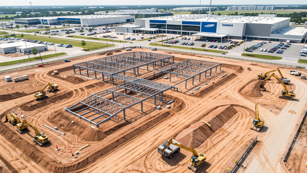
Home to Samsung's $17 billion semiconductor plant, the largest private capital investment in Texas history, Taylor is transforming from a small farming town into a major industrial hub driving earthwork, utility, residential, and infrastructure construction.
Serving Williamson County & the Austin-Round Rock-San Marcos area
Request a Free Quote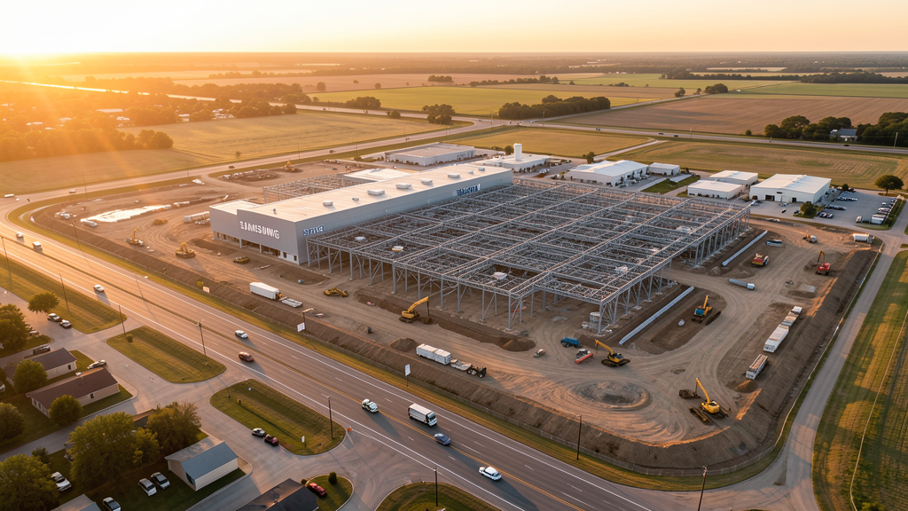
Get Matched With a Local Surveyor
Drone Survey Services Available in Taylor, TX
Taylor sits in eastern Williamson County along US Highway 79, about 30 miles northeast of Austin. The city is the site of Samsung's $17 billion semiconductor manufacturing campus, the largest private capital investment in Texas history. The project is driving massive ancillary development including residential subdivisions, supply chain facilities, hotel construction, and infrastructure expansion. US Highway 79 is being widened, and water/utility infrastructure is being upgraded to serve the plant.
Drone Surveys for Taylor's Construction Market
Taylor is the site of Samsung's $17 billion semiconductor manufacturing campus, the largest private capital investment in Texas history. The plant is driving massive ancillary development: residential subdivisions, supply chain facilities, hotel construction, and infrastructure expansion. The city has grown from 16,000 to over 18,000 residents with rapid acceleration expected as the plant becomes operational. US Highway 79 is being expanded to accommodate increased traffic, and the Williamson County water and utility infrastructure is being upgraded to serve the plant. Drone surveys are critical for earthwork monitoring, utility mapping, and construction progress tracking on the Samsung site and surrounding developments.
Active Developers in the Area:
Typical Project Costs in Texas
Cost ranges are based on market data for Austin-Round Rock-San Marcos. Actual pricing depends on site size, complexity, and deliverables.
| Service Type | Low End | High End |
|---|---|---|
| Topographic Survey | $1,800 | $4,500 |
| Drone Inspection | $250 | $850 |
| LiDAR Scanning | $2,800 | $8,000 |
| Environmental Monitoring | $800 | $3,000 |
| Aerial Imagery | $175 | $500 |
| Construction Monitoring | $1,100 | $3,200 |
| Real Estate Photography | $150 | $450 |
| Roof Inspection | $200 | $750 |
Local Airspace & Regulations in Taylor, TX
FAA Part 107 Requirements
All commercial drone operations in Texas require the pilot to hold an active FAA Part 107 Remote Pilot Certificate. Our network surveyors are verified Part 107 holders.
State Drone Laws
Texas Government Code Chapter 423 restricts drone use over critical infrastructure facilities, including oil and gas pipelines, refineries, power plants, and water treatment facilities. HB 1484 (2023) added protections for agricultural operations and expanded penalties for drone surveillance of private property. Commercial operators must hold a valid FAA Part 107 Remote Pilot Certificate. Texas does not require a separate state drone license, but operators flying near critical infrastructure must obtain authorization from the facility owner. The Texas Department of Public Safety maintains additional guidelines for drone operations near state facilities.
Local Ordinances
Taylor follows Williamson County regulations and FAA Part 107 rules. No city-specific drone permit is required for operations from private property. The city has a municipal airport (TML) and pilots should notify the airport manager when operating nearby. The Samsung plant construction zone may have TFRs — always check NOTAMs. Taylor Parks and Recreation prohibits drone takeoff/landing in Murphy Park and other city parks without a permit.
Restricted Airspace
- Class C airspace around Austin-Bergstrom (AUS) extends 20 nautical miles. The southern edge of Taylor may fall within LAANC-required zones depending on altitude.
- Class D airspace around Georgetown Municipal (GEU) — LAANC authorization required within 4 nautical miles.
- Taylor Municipal Airport (TML) is Class E airspace — no LAANC required but pilots must notify the airport manager if operating within 5 miles.
- The Samsung semiconductor plant construction site may have temporary flight restrictions (TFRs) during certain construction phases. Check NOTAMs before flying.
Airports in the area: undefined (undefined), undefined (undefined), undefined (undefined), undefined (undefined)
Why Hire Through Aerius View in Taylor, TX?
FAA-Certified
Every surveyor holds an active Part 107 Remote Pilot Certificate.
Local to Taylor
Surveyors who know the Texas airspace and local permitting.
No Cost to Quote
Submit your project at no charge. Pay the surveyor directly if you proceed.
Fast Turnaround
A local surveyor contacts you within 2 business days.
How Our Taylor Matching Process Works
We're actively building our network of FAA-certified drone operators in Taylor, TX. Here's exactly what happens when you submit a project request.
Submit Your Project
Tell us your site location, acreage, and what you need (topographic survey, LiDAR, inspection, etc.). Takes 60 seconds. No cost, no obligation.
We Match & Vet
We identify Part 107-certified operators in Texas with the right equipment for your project. Every pilot is verified for active certification, insurance, and relevant experience in Texas airspace.
You Get Quotes
Matched surveyors contact you within 2 business days with quotes. You compare pricing, timelines, and deliverables, then choose the right fit. You pay the surveyor directly, no markup.
What Deliverables Do You Get?
Every project includes professional-grade deliverables compatible with standard construction and engineering software:
- Orthomosaic maps (GeoTIFF) for site overview and documentation
- Point clouds (LAS/LAZ) for 3D modeling and volumetric analysis
- DEM/DSM terrain models for cut/fill and grade analysis
- Contour lines (DXF/DWG, CAD-ready) for Civil 3D and Revit
- Progress reports with side-by-side comparisons for construction monitoring
- Coordinate systems matched to your project datum (State Plane, UTM, or local)
Insurance & Liability Protection
Pilot Insurance Required
Every operator in our network must carry active liability insurance. Minimum coverage: $1,000,000 general liability. Proof of insurance is verified before any pilot joins the network.
FAA Part 107 Verified
We confirm each pilot's Remote Pilot Certificate is active and in good standing through the FAA Airmen Inquiry system. Expired certificates are flagged automatically.
Equipment Documentation
Pilots list their drone models, sensors (RGB, LiDAR, thermal, multispectral), and payload specs so we can match the right equipment to your project requirements.
Site Safety Coordination
Pilots coordinate with your site superintendent for safe operations on active construction sites, including flight plans that avoid worker areas and equipment zones.
Taylor, TX Drone Survey FAQs
Do I need a permit for a drone survey in Taylor?
No city-specific permit is required for commercial drone operations from private property in Taylor. All flights must comply with FAA Part 107 rules. The Samsung construction site may have TFRs — always check NOTAMs before flying. Operations near Georgetown Municipal Airport require LAANC authorization.
How much does a drone survey cost in Taylor, TX?
Topographic surveys in Williamson County typically range from $1,800 to $4,500. Roof inspections run $200-$750. LiDAR scanning for the Samsung plant or industrial sites costs $2,800-$8,000. Construction monitoring for ongoing Samsung-related projects starts at $1,100/month.
Can I fly a drone over the Samsung construction site?
The Samsung semiconductor construction site may have temporary flight restrictions during certain construction phases. Always check NOTAMs before flying near the site. Even without a TFR, operating near heavy construction equipment requires coordination with site managers. Our surveyors coordinate with Samsung contractors for authorized access.
What makes Taylor unique for drone surveys?
Taylor is the site of Samsung's $17 billion semiconductor plant, the largest private capital investment in Texas history. The construction is driving earthwork, utility mapping, residential development, and infrastructure expansion that all require aerial survey support. US Highway 79 expansion and water utility upgrades add to survey demand.
How long does a topographic survey take in Taylor?
A standard 50-acre site can be flown in under an hour. Deliverables including DEM, contour maps, orthomosaic, and point cloud are ready within 3-5 business days. Large industrial sites like the Samsung campus may require multiple flights over several days for complete coverage.
Nearby Cities
Are You a Drone Surveyor in Taylor?
Get pre-qualified leads in your service area. No membership fees, no monthly minimums. First lead free.
Ready to Start Your Project in Taylor, TX?
Get matched with a local, FAA-certified surveyor. No cost, no obligation.
Request a Free Quote