Drone Survey Services in Quartzsite, AZ
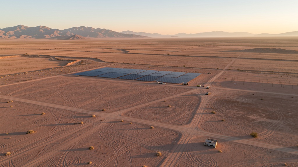
From solar energy projects in La Paz County to seasonal RV infrastructure and Highway 95 improvements, Quartzsite is a tiny desert town where BLM recreation lands, extreme heat, and the world largest winter RV gathering shape every survey mission.
Serving La Paz County & the Quartzsite area
Request a Free Quote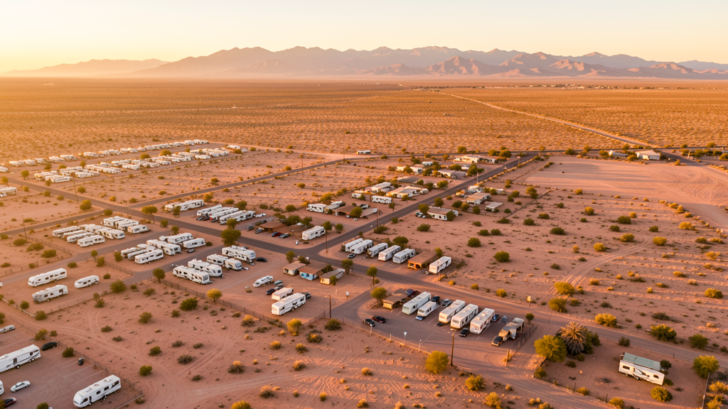
Get Matched With a Local Surveyor
Drone Survey Services Available in Quartzsite, AZ
Quartzsite is famous for winter RV gatherings and gem shows. Permanent construction is minimal but seasonal infrastructure demands are significant. Solar energy projects in La Paz County are an emerging market. The remote location with limited cell coverage requires self-sufficient operations. Summer heat exceeds 115 degrees.
Drone Surveys for Quartzsite's Construction Market
Quartzsite is a tiny desert town famous for its winter RV gatherings, gem and mineral shows, and flea markets. Permanent construction is minimal, but the town sees seasonal infrastructure demands during the winter RV season. The town has invested in water infrastructure and public facility improvements to accommodate seasonal visitors. Solar energy projects in the surrounding La Paz County desert are an emerging market for aerial survey. The nearby Colorado River and Parker Dam area have some infrastructure survey needs. Highway 95 improvements connecting Quartzsite to I-10 generate occasional infrastructure survey demand. The town serves as a service center for surrounding BLM recreation areas.
Active Developers in the Area:
Typical Project Costs in Arizona
Cost ranges are based on market data for Quartzsite. Actual pricing depends on site size, complexity, and deliverables.
| Service Type | Low End | High End |
|---|---|---|
| Topographic Survey | $1,800 | $4,500 |
| Drone Inspection | $250 | $850 |
| LiDAR Scanning | $2,800 | $8,500 |
| Environmental Monitoring | $800 | $3,200 |
| Aerial Imagery | $175 | $500 |
| Construction Monitoring | $1,200 | $3,200 |
| Real Estate Photography | $175 | $450 |
| Roof Inspection | $225 | $800 |
Local Airspace & Regulations in Quartzsite, AZ
FAA Part 107 Requirements
All commercial drone operations in Arizona require the pilot to hold an active FAA Part 107 Remote Pilot Certificate. Our network surveyors are verified Part 107 holders.
State Drone Laws
Arizona SB 1449 (2016) was the first state law regulating drone use, prohibiting drone operations that interfere with law enforcement, emergency responders, or wildfire suppression efforts. The law prohibits drone flights within 3 miles of a wildfire or prescribed burn and makes violation a class 1 misdemeanor. ARS Title 13 Chapter 29 Article 3 restricts drone surveillance of private property and weaponization of drones. Commercial operators must hold a valid FAA Part 107 Remote Pilot Certificate. Arizona does not require a separate state drone license, but operators must comply with FAA Part 107 rules and any local ordinances. The Arizona Department of Public Safety maintains guidelines for drone operations near critical infrastructure including power plants, dams, and military installations.
Local Ordinances
Quartzsite follows La Paz County regulations for drone operations. Commercial operators must hold FAA Part 107 certification. The town does not have a specific drone ordinance. During the winter RV season (January-February), the town population swells from 3,700 to over 100,000 with RV visitors. Drone flights over the RV gathering areas should be coordinated with event organizers and the La Paz County Sheriffs Office. BLM land surrounding the town generally allows drone operations but special recreation event areas may have temporary restrictions. The remote location means operators must be self-sufficient with no nearby services.
Restricted Airspace
- Quartzsite Airport (P20) is uncontrolled with minimal traffic. Drone operators should monitor CTAF 122.9 and maintain visual line of sight.
- Quartzsite is surrounded by BLM land with extensive off-highway vehicle (OHV) recreation areas. While BLM land generally allows drone operations, special recreation event areas may have temporary restrictions.
- The town is in a remote desert location with extremely limited cell coverage. Pre-programmed waypoint missions are essential for any survey work outside the town center.
- Winter RV influx: Quartzsite hosts the largest RV gathering in the world each January-February with over 1 million visitors. Temporary flight restrictions may be in effect during major events. Check NOTAMs before flying during winter months.
- Summer temperatures regularly exceed 115 degrees with very low humidity. Drone battery thermal shutdowns are a severe risk. Early morning flights are mandatory June through September.
Airports in the area: undefined (undefined), undefined (undefined), undefined (undefined)
Why Hire Through Aerius View in Quartzsite, AZ?
FAA-Certified
Every surveyor holds an active Part 107 Remote Pilot Certificate.
Local to Quartzsite
Surveyors who know the Arizona airspace and local permitting.
No Cost to Quote
Submit your project at no charge. Pay the surveyor directly if you proceed.
Fast Turnaround
A local surveyor contacts you within 2 business days.
How Our Quartzsite Matching Process Works
We're actively building our network of FAA-certified drone operators in Quartzsite, AZ. Here's exactly what happens when you submit a project request.
Submit Your Project
Tell us your site location, acreage, and what you need (topographic survey, LiDAR, inspection, etc.). Takes 60 seconds. No cost, no obligation.
We Match & Vet
We identify Part 107-certified operators in Arizona with the right equipment for your project. Every pilot is verified for active certification, insurance, and relevant experience in Arizona airspace.
You Get Quotes
Matched surveyors contact you within 2 business days with quotes. You compare pricing, timelines, and deliverables, then choose the right fit. You pay the surveyor directly, no markup.
What Deliverables Do You Get?
Every project includes professional-grade deliverables compatible with standard construction and engineering software:
- Orthomosaic maps (GeoTIFF) for site overview and documentation
- Point clouds (LAS/LAZ) for 3D modeling and volumetric analysis
- DEM/DSM terrain models for cut/fill and grade analysis
- Contour lines (DXF/DWG, CAD-ready) for Civil 3D and Revit
- Progress reports with side-by-side comparisons for construction monitoring
- Coordinate systems matched to your project datum (State Plane, UTM, or local)
Insurance & Liability Protection
Pilot Insurance Required
Every operator in our network must carry active liability insurance. Minimum coverage: $1,000,000 general liability. Proof of insurance is verified before any pilot joins the network.
FAA Part 107 Verified
We confirm each pilot's Remote Pilot Certificate is active and in good standing through the FAA Airmen Inquiry system. Expired certificates are flagged automatically.
Equipment Documentation
Pilots list their drone models, sensors (RGB, LiDAR, thermal, multispectral), and payload specs so we can match the right equipment to your project requirements.
Site Safety Coordination
Pilots coordinate with your site superintendent for safe operations on active construction sites, including flight plans that avoid worker areas and equipment zones.
Quartzsite, AZ Drone Survey FAQs
Do I need a permit for a drone survey in Quartzsite?
Quartzsite follows La Paz County regulations. You need a permit only for flights on public property. Surveys from private property with owner permission do not require a town permit. All commercial operations require FAA Part 107 certification.
Can I fly drones during the winter RV season?
Quartzsite hosts the largest RV gathering in the world each January-February with over 1 million visitors. Temporary flight restrictions may be in effect during major events. Check NOTAMs before flying. Coordinate with event organizers and the La Paz County Sheriffs Office for any survey work near RV gathering areas.
What are the main survey needs in Quartzsite?
Solar energy projects in La Paz County, water infrastructure improvements, and Highway 95 improvements are the primary needs. The town serves as a service center for surrounding BLM recreation areas. Seasonal infrastructure demands during the winter RV season also generate occasional survey work.
How does the remote location affect drone operations?
Quartzsite is in a remote desert location with extremely limited cell coverage. Pre-programmed waypoint missions are essential for any survey work outside the town center. Operators must be self-sufficient with no nearby services. Summer temperatures exceed 115 degrees with very low humidity, making battery thermal shutdowns a severe risk.
How much does a drone survey cost in Quartzsite?
Topographic surveys range from $1,800 to $4,500. Roof inspections run $225-$800. LiDAR scanning for larger desert sites can cost $2,800-$8,500. Solar farm site surveys may have specialized pricing. The remote location may add travel costs for survey crews.
Nearby Cities
Are You a Drone Surveyor in Quartzsite?
Get pre-qualified leads in your service area. No membership fees, no monthly minimums. First lead free.
Ready to Start Your Project in Quartzsite, AZ?
Get matched with a local, FAA-certified surveyor. No cost, no obligation.
Request a Free Quote