Drone Survey Services in Prosper, TX
From Windsong Ranch and Light Farms master-planned communities to Highway 380 commercial frontage, Prosper is among the fastest-growing Collin County towns with 30%+ population growth driving nonstop residential and mixed-use construction.
Serving Collin County & the Dallas-Fort Worth-Arlington area
Request a Free Quote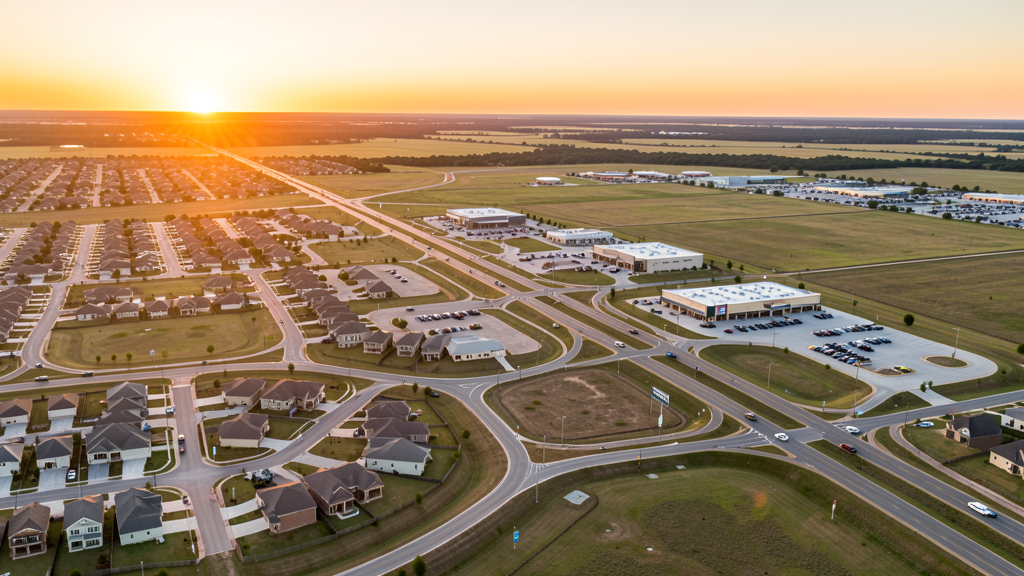
Get Matched With a Local Surveyor
Drone Survey Services Available in Prosper, TX
Prosper sits in the explosive Highway 380 corridor of northern Collin County, one of the fastest-growing counties in the US. The town has grown from 12,000 to over 41,000 residents in a decade, driven by master-planned communities like Windsong Ranch and Light Farms. Construction along Preston Road and Highway 380 includes retail, medical offices, and corporate campuses supporting the residential boom.
Drone Surveys for Prosper's Construction Market
Prosper is one of the fastest-growing towns in Collin County, with 30%+ population growth since 2020. The Windsong development and multiple master-planned communities along Highway 380 are driving massive residential and mixed-use construction. The town is attracting commercial development along the Preston Road corridor, with retail centers, medical offices, and corporate campuses breaking ground. Collin County consistently leads Texas in residential permit volume, and Prosper is a primary contributor to that growth.
Active Developers in the Area:
Typical Project Costs in Texas
Cost ranges are based on market data for Dallas-Fort Worth-Arlington. Actual pricing depends on site size, complexity, and deliverables.
| Service Type | Low End | High End |
|---|---|---|
| Topographic Survey | $1,800 | $4,500 |
| Drone Inspection | $250 | $850 |
| LiDAR Scanning | $2,800 | $8,000 |
| Environmental Monitoring | $800 | $3,000 |
| Aerial Imagery | $175 | $500 |
| Construction Monitoring | $1,100 | $3,200 |
| Real Estate Photography | $150 | $450 |
| Roof Inspection | $200 | $750 |
Local Airspace & Regulations in Prosper, TX
FAA Part 107 Requirements
All commercial drone operations in Texas require the pilot to hold an active FAA Part 107 Remote Pilot Certificate. Our network surveyors are verified Part 107 holders.
State Drone Laws
Texas Government Code Chapter 423 restricts drone use over critical infrastructure facilities, including oil and gas pipelines, refineries, power plants, and water treatment facilities. HB 1484 (2023) added protections for agricultural operations and expanded penalties for drone surveillance of private property. Commercial operators must hold a valid FAA Part 107 Remote Pilot Certificate. Texas does not require a separate state drone license, but operators flying near critical infrastructure must obtain authorization from the facility owner. The Texas Department of Public Safety maintains additional guidelines for drone operations near state facilities.
Local Ordinances
Prosper follows Collin County and FAA Part 107 regulations. No city-specific drone permit is required for operations from private property. Commercial flights near DFW or McKinney National require LAANC authorization. The town prohibits drone takeoff/landing in town parks without a special use permit. Frontage Road and Highway 380 corridor construction sites often require aerial surveys for site planning.
Restricted Airspace
- Class B airspace around DFW International extends 30 nautical miles from the airport. LAANC authorization required for commercial drone flights within this zone.
- Class D airspace around McKinney National (TKI) — requires LAANC authorization within 4 nautical miles.
- Class D airspace around Addison Airport (ADS) — requires LAANC authorization within 4 nautical miles.
- Collin County has no county-level drone ordinance, but Prosper town parks prohibit takeoff/landing without a special use permit.
Airports in the area: undefined (undefined), undefined (undefined), undefined (undefined), undefined (undefined)
Why Hire Through Aerius View in Prosper, TX?
FAA-Certified
Every surveyor holds an active Part 107 Remote Pilot Certificate.
Local to Prosper
Surveyors who know the Texas airspace and local permitting.
No Cost to Quote
Submit your project at no charge. Pay the surveyor directly if you proceed.
Fast Turnaround
A local surveyor contacts you within 2 business days.
How Our Prosper Matching Process Works
We're actively building our network of FAA-certified drone operators in Prosper, TX. Here's exactly what happens when you submit a project request.
Submit Your Project
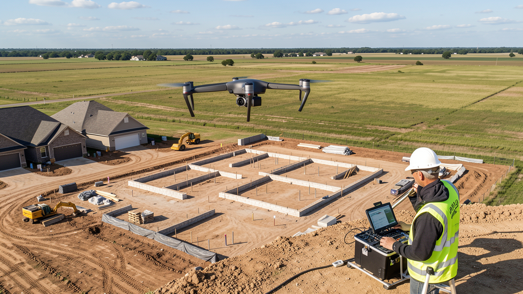
Tell us your site location, acreage, and what you need (topographic survey, LiDAR, inspection, etc.). Takes 60 seconds. No cost, no obligation.
We Match & Vet
We identify Part 107-certified operators in Texas with the right equipment for your project. Every pilot is verified for active certification, insurance, and relevant experience in Texas airspace.
You Get Quotes
Matched surveyors contact you within 2 business days with quotes. You compare pricing, timelines, and deliverables, then choose the right fit. You pay the surveyor directly, no markup.
What Deliverables Do You Get?
Every project includes professional-grade deliverables compatible with standard construction and engineering software:
- Orthomosaic maps (GeoTIFF) for site overview and documentation
- Point clouds (LAS/LAZ) for 3D modeling and volumetric analysis
- DEM/DSM terrain models for cut/fill and grade analysis
- Contour lines (DXF/DWG, CAD-ready) for Civil 3D and Revit
- Progress reports with side-by-side comparisons for construction monitoring
- Coordinate systems matched to your project datum (State Plane, UTM, or local)
Insurance & Liability Protection
Pilot Insurance Required
Every operator in our network must carry active liability insurance. Minimum coverage: $1,000,000 general liability. Proof of insurance is verified before any pilot joins the network.
FAA Part 107 Verified
We confirm each pilot's Remote Pilot Certificate is active and in good standing through the FAA Airmen Inquiry system. Expired certificates are flagged automatically.
Equipment Documentation
Pilots list their drone models, sensors (RGB, LiDAR, thermal, multispectral), and payload specs so we can match the right equipment to your project requirements.
Site Safety Coordination
Pilots coordinate with your site superintendent for safe operations on active construction sites, including flight plans that avoid worker areas and equipment zones.
Prosper, TX Drone Survey FAQs
Do I need a permit for a drone survey in Prosper?
No city-specific permit is required for commercial drone operations from private property in Prosper. All flights must comply with FAA Part 107 rules. If operating near DFW or McKinney National airports, LAANC authorization is required for Class B and D airspace. Takeoff/landing in town parks requires a special use permit from the town.
How much does a drone survey cost in Prosper, TX?
Topographic surveys in Collin County typically range from $1,800 to $4,500. Roof inspections run $200-$750. LiDAR scanning for larger residential or commercial sites costs $2,800-$8,000. Real estate drone photography starts at $150.
Can drones fly near DFW International Airport from Prosper?
Prosper is about 15 miles from DFW, which is within the outer shelf of DFW Class B airspace. Commercial drone flights in this area require LAANC authorization. Our network surveyors handle all LAANC approvals automatically as part of the service.
What construction projects are driving drone survey demand in Prosper?
Windsong Ranch, Light Farms, and multiple Highway 380 corridor developments require ongoing topographic surveys, earthwork volume calculations, and construction monitoring. Over 2,000 residential lots are in active development, plus commercial frontage along Preston Road.
How long does a topographic survey take in Prosper?
A standard 50-acre site can be flown in under an hour. Deliverables including DEM, contour maps, orthomosaic, and point cloud are ready within 3-5 business days. Collin County terrain is relatively flat, making flights straightforward, but wind from open prairie can affect scheduling in spring.
Nearby Cities
Are You a Drone Surveyor in Prosper?
Get pre-qualified leads in your service area. No membership fees, no monthly minimums. First lead free.
Ready to Start Your Project in Prosper, TX?
Get matched with a local, FAA-certified surveyor. No cost, no obligation.
Request a Free Quote