Drone Survey Services in Green Valley, AZ
From roof inspections on retirement community homes to solar farm site surveys and Sierrita Mine environmental monitoring, Green Valley is a Pima County community with steady demand for inspection and mining aerial survey work.
Serving Pima County & the Tucson area
Request a Free Quote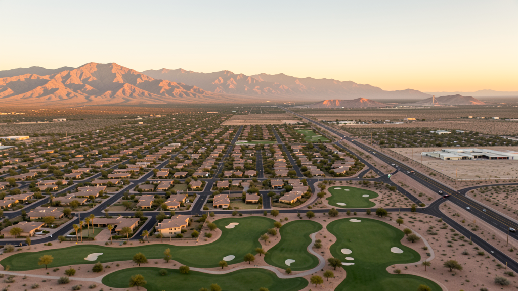
Get Matched With a Local Surveyor
Drone Survey Services Available in Green Valley, AZ
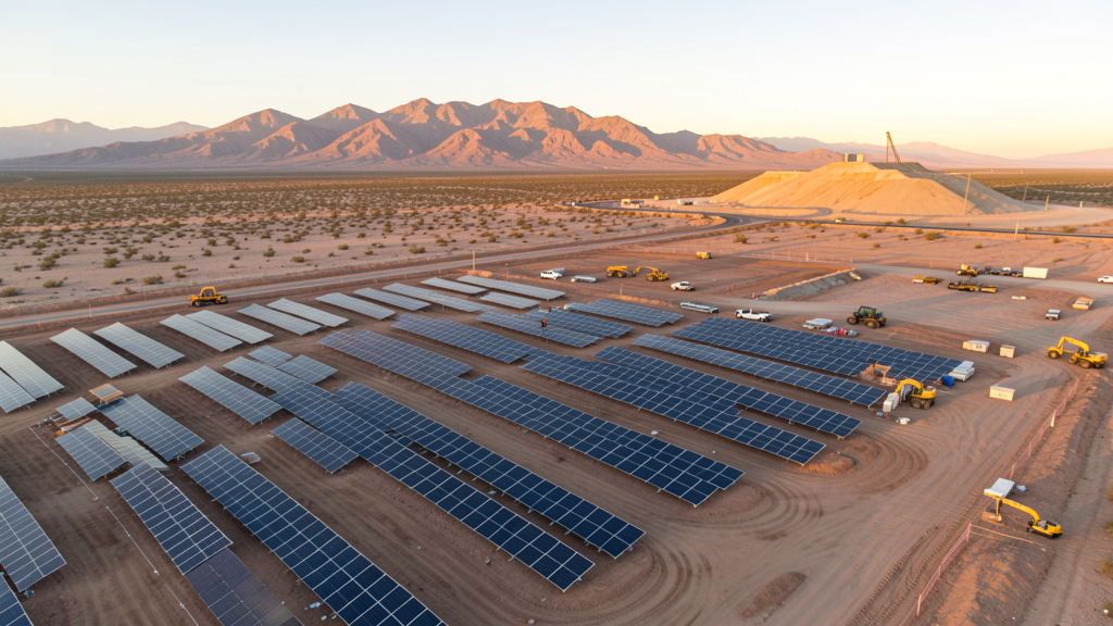
Green Valley is primarily a retirement community with demand for roof inspections, real estate photography, and solar farm surveys. The nearby Sierrita Mine requires environmental monitoring. Water infrastructure projects along I-19 also generate survey demand.
Drone Surveys for Green Valley's Construction Market
Green Valley is primarily a retirement community with limited new construction compared to Sahuarita or Marana. However, there is sustained demand for roof inspections on older homes, aerial photography for real estate listings, and survey work for the nearby Freeport-McMoRan Sierrita Mine. Solar farm development in the area, including the Avalon Solar project, generates demand for aerial site survey and monitoring. Water infrastructure projects along the I-19 corridor also require survey services.
Active Developers in the Area:
Typical Project Costs in Arizona
Cost ranges are based on market data for Tucson. Actual pricing depends on site size, complexity, and deliverables.
| Service Type | Low End | High End |
|---|---|---|
| Topographic Survey | $1,800 | $4,500 |
| Drone Inspection | $250 | $850 |
| LiDAR Scanning | $2,800 | $8,500 |
| Environmental Monitoring | $800 | $3,200 |
| Aerial Imagery | $175 | $500 |
| Construction Monitoring | $1,200 | $3,200 |
| Real Estate Photography | $175 | $450 |
| Roof Inspection | $225 | $800 |
Local Airspace & Regulations in Green Valley, AZ
FAA Part 107 Requirements
All commercial drone operations in Arizona require the pilot to hold an active FAA Part 107 Remote Pilot Certificate. Our network surveyors are verified Part 107 holders.
State Drone Laws
Arizona SB 1449 (2016) was the first state law regulating drone use, prohibiting drone operations that interfere with law enforcement, emergency responders, or wildfire suppression efforts. The law prohibits drone flights within 3 miles of a wildfire or prescribed burn and makes violation a class 1 misdemeanor. ARS Title 13 Chapter 29 Article 3 restricts drone surveillance of private property and weaponization of drones. Commercial operators must hold a valid FAA Part 107 Remote Pilot Certificate. Arizona does not require a separate state drone license, but operators must comply with FAA Part 107 rules and any local ordinances. The Arizona Department of Public Safety maintains guidelines for drone operations near critical infrastructure including power plants, dams, and military installations.
Local Ordinances
Green Valley is an unincorporated community in Pima County and follows county regulations for drone operations. Commercial operators must hold FAA Part 107 certification. As a retirement community, Green Valley has active HOAs and community associations that may have their own guidelines for drone flights. The Green Valley Council represents homeowner associations and may address drone-related concerns. Flights over the adjacent Tohono Oodham Nation reservation require tribal government permission.
Restricted Airspace
- Green Valley is outside Class C airspace but is near the Freeport-McMoRan Sierrita Mine, which has active restricted airspace for safety and security. Coordinate with mine operations before flying near the mine.
- Tohono Oodham Nation reservation boundary is approximately 10 miles west. Drone flights over tribal land require permission from the tribal government.
- Madera Canyon and the Santa Rita Mountains to the east include Coronado National Forest and designated wilderness areas where drone flights are prohibited.
- The Sahuarita Airspace Alert Area is east of Green Valley. While not restricted, operators should be aware of military training activity in this area.
- Solar power installations in the area may have security protocols for drone overflights. Coordinate with facility operators before conducting inspection work.
Airports in the area: undefined (undefined), undefined (undefined)
Why Hire Through Aerius View in Green Valley, AZ?
FAA-Certified
Every surveyor holds an active Part 107 Remote Pilot Certificate.
Local to Green Valley
Surveyors who know the Arizona airspace and local permitting.
No Cost to Quote
Submit your project at no charge. Pay the surveyor directly if you proceed.
Fast Turnaround
A local surveyor contacts you within 2 business days.
How Our Green Valley Matching Process Works
We're actively building our network of FAA-certified drone operators in Green Valley, AZ. Here's exactly what happens when you submit a project request.
Submit Your Project
Tell us your site location, acreage, and what you need (topographic survey, LiDAR, inspection, etc.). Takes 60 seconds. No cost, no obligation.
We Match & Vet
We identify Part 107-certified operators in Arizona with the right equipment for your project. Every pilot is verified for active certification, insurance, and relevant experience in Arizona airspace.
You Get Quotes
Matched surveyors contact you within 2 business days with quotes. You compare pricing, timelines, and deliverables, then choose the right fit. You pay the surveyor directly, no markup.
What Deliverables Do You Get?
Every project includes professional-grade deliverables compatible with standard construction and engineering software:
- Orthomosaic maps (GeoTIFF) for site overview and documentation
- Point clouds (LAS/LAZ) for 3D modeling and volumetric analysis
- DEM/DSM terrain models for cut/fill and grade analysis
- Contour lines (DXF/DWG, CAD-ready) for Civil 3D and Revit
- Progress reports with side-by-side comparisons for construction monitoring
- Coordinate systems matched to your project datum (State Plane, UTM, or local)
Insurance & Liability Protection
Pilot Insurance Required
Every operator in our network must carry active liability insurance. Minimum coverage: $1,000,000 general liability. Proof of insurance is verified before any pilot joins the network.
FAA Part 107 Verified
We confirm each pilot's Remote Pilot Certificate is active and in good standing through the FAA Airmen Inquiry system. Expired certificates are flagged automatically.
Equipment Documentation
Pilots list their drone models, sensors (RGB, LiDAR, thermal, multispectral), and payload specs so we can match the right equipment to your project requirements.
Site Safety Coordination
Pilots coordinate with your site superintendent for safe operations on active construction sites, including flight plans that avoid worker areas and equipment zones.
Green Valley, AZ Drone Survey FAQs
Do I need a permit for a drone survey in Green Valley?
Green Valley is unincorporated and follows Pima County regulations. You need a permit only for flights on public property. Surveys from private property with owner permission do not require a permit. All commercial operations require FAA Part 107 certification.
Can I fly a drone near the Sierrita Mine?
The Freeport-McMoRan Sierrita Mine has active restricted airspace for safety and security. Coordinate with mine operations before scheduling aerial survey work near the mine. The mine requires regular environmental monitoring surveys, which are typically contracted through approved vendors.
What are the main survey needs in Green Valley?
Roof inspections on older retirement community homes, real estate aerial photography, solar farm site surveys, and mining environmental monitoring are the primary needs. Water infrastructure projects along I-19 also require survey services.
Are there restrictions near Madera Canyon?
Yes. Madera Canyon is within the Coronado National Forest and includes designated wilderness areas where drone flights are prohibited by the US Forest Service. Plan survey routes that avoid Forest Service boundaries east of Green Valley.
How much does a roof inspection cost in Green Valley?
Roof inspections in Green Valley typically range from $225 to $800 depending on roof size and complexity. Many homes in the retirement community have tile roofs that require careful inspection. Drone roof inspections are significantly safer and more cost-effective than manual inspections for multi-story homes.
Nearby Cities
Are You a Drone Surveyor in Green Valley?
Get pre-qualified leads in your service area. No membership fees, no monthly minimums. First lead free.
Ready to Start Your Project in Green Valley, AZ?
Get matched with a local, FAA-certified surveyor. No cost, no obligation.
Request a Free Quote