Drone Survey Services in Fallon, NV
Carson Desert high plains at 3,900 feet with NAS Fallon flight line and Lahontan Valley irrigation
Serving Churchill County & the Fallon Micropolitan Area area
Request a Free Quote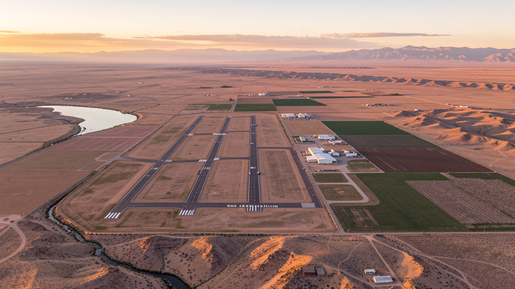
Get Matched With a Local Surveyor
Drone Survey Services Available in Fallon, NV
Fallon is dominated by Naval Air Station Fallon, home of the Navy TOPGUN program. Military construction, agricultural irrigation infrastructure, and modest residential development drive drone survey demand, with extensive Navy restricted airspace creating the primary operational constraint.
Drone Surveys for Fallon's Construction Market
Fallon construction is driven by Naval Air Station Fallon infrastructure, agriculture, and residential development. NAS Fallon expansion for Navy training facilities creates specialized defense construction demand. The Fallon Naval Air Station is a major employer. Agricultural infrastructure including the Newlands Project irrigation system creates ongoing maintenance construction. The city has modest residential development serving the military and agricultural workforce.
Active Developers in the Area:
- US Navy — NAS Fallon facility construction and training infrastructure upgrades
- Churchill County — Road infrastructure and county facility upgrades
- Agricultural irrigation district — Newlands Project irrigation infrastructure maintenance

Typical Project Costs in Nevada
Cost ranges are based on market data for Fallon Micropolitan Area. Actual pricing depends on site size, complexity, and deliverables.
| Service Type | Low End | High End |
|---|---|---|
| Topographic Survey | $1,100 | $5,500 |
| Drone Inspection | $400 | $2,200 |
| LiDAR Scanning | $1,800 | $9,000 |
| Environmental Monitoring | $900 | $4,500 |
| Aerial Imagery | $250 | $1,500 |
| Construction Monitoring | $500 | $2,500 |
| Real Estate Photography | $200 | $900 |
| Roof Inspection | $200 | $1,000 |
Local Airspace & Regulations in Fallon, NV
FAA Part 107 Requirements
All commercial drone operations in Nevada require the pilot to hold an active FAA Part 107 Remote Pilot Certificate. Our network surveyors are verified Part 107 holders.
State Drone Laws
Nevada enacted AB 269 (2015), establishing the Governor Office of Economic Development UAS program and preempting local municipalities from regulating drone flight paths, airspace, or pilot licensing. SB 92 (2017) added privacy protections prohibiting drone surveillance of private property without consent and restricting weaponization. AB 487 (2019) further clarified that only the state may regulate UAS operations, preventing cities and counties from enacting their own drone flight restrictions. Nevada hosts major restricted military airspace including Nellis Air Force Base, Creech Air Force Base (home to MQ-1 Predator and MQ-9 Reaper operations), Naval Air Station Fallon, and the Nevada Test and Training Range — one of the largest restricted airspace complexes in the continental US. Commercial operators must hold a valid FAA Part 107 Remote Pilot Certificate. The state does not require a separate state drone license. Operators flying near military installations, the Nevada National Security Site, or tribal lands must coordinate with the controlling agency. Nevada desert terrain and extreme summer temperatures (frequently above 110 degrees in southern NV) significantly affect drone battery life and motor performance.
Local Ordinances
Fallon follows FAA Part 107 regulations. Under Nevada state law (AB 487, 2019), local municipalities cannot regulate drone flight paths. Naval Air Station Fallon, directly south of the city, has extensive restricted airspace for Navy fighter training including the Navy Fighter Weapons School (TOPGUN). Operators must coordinate with NAS Fallon for any flights near the restricted boundary.
Restricted Airspace
- Naval Air Station Fallon restricted airspace (R-4802) directly south of city
- Fallon Municipal Airport in Class G airspace
- US Navy TOPGUN training airspace creates frequent TFRs
- Carson Sink desert terrain with minimal civilian restrictions beyond military
Airports in the area: Naval Air Station Fallon (NFL), Fallon Municipal Airport (FLX)
Why Hire Through Aerius View in Fallon, NV?
FAA-Certified
Every surveyor holds an active Part 107 Remote Pilot Certificate.
Local to Fallon
Surveyors who know the Nevada airspace and local permitting.
No Cost to Quote
Submit your project at no charge. Pay the surveyor directly if you proceed.
Fast Turnaround
A local surveyor contacts you within 2 business days.
How Our Fallon Matching Process Works
We're actively building our network of FAA-certified drone operators in Fallon, NV. Here's exactly what happens when you submit a project request.
Submit Your Project
Tell us your site location, acreage, and what you need (topographic survey, LiDAR, inspection, etc.). Takes 60 seconds. No cost, no obligation.
We Match & Vet
We identify Part 107-certified operators in Nevada with the right equipment for your project. Every pilot is verified for active certification, insurance, and relevant experience in Nevada airspace.
You Get Quotes
Matched surveyors contact you within 2 business days with quotes. You compare pricing, timelines, and deliverables, then choose the right fit. You pay the surveyor directly, no markup.
What Deliverables Do You Get?
Every project includes professional-grade deliverables compatible with standard construction and engineering software:
- Orthomosaic maps (GeoTIFF) for site overview and documentation
- Point clouds (LAS/LAZ) for 3D modeling and volumetric analysis
- DEM/DSM terrain models for cut/fill and grade analysis
- Contour lines (DXF/DWG, CAD-ready) for Civil 3D and Revit
- Progress reports with side-by-side comparisons for construction monitoring
- Coordinate systems matched to your project datum (State Plane, UTM, or local)
Insurance & Liability Protection
Pilot Insurance Required
Every operator in our network must carry active liability insurance. Minimum coverage: $1,000,000 general liability. Proof of insurance is verified before any pilot joins the network.
FAA Part 107 Verified
We confirm each pilot's Remote Pilot Certificate is active and in good standing through the FAA Airmen Inquiry system. Expired certificates are flagged automatically.
Equipment Documentation
Pilots list their drone models, sensors (RGB, LiDAR, thermal, multispectral), and payload specs so we can match the right equipment to your project requirements.
Site Safety Coordination
Pilots coordinate with your site superintendent for safe operations on active construction sites, including flight plans that avoid worker areas and equipment zones.
Fallon, NV Drone Survey FAQs
Can I fly a drone near Naval Air Station Fallon?
NAS Fallon has extensive restricted airspace (R-4802) directly south of the city. The base is home to the Navy Fighter Weapons School (TOPGUN) and conducts intensive fighter training. The restricted zone is frequently active with high-speed military aircraft. Drone operators must coordinate with NAS Fallon for any flights near the restricted boundary.
What drone services are most needed in Fallon?
Naval base infrastructure construction monitoring is a primary need. Agricultural survey for the Newlands Project irrigation area is a potential service. Residential and county facility construction provides modest survey demand. Environmental monitoring of the Carson Sink desert and wetlands is a specialized area.
Does Fallon have civilian controlled airspace?
Fallon Municipal Airport (FLX) is in Class G (uncontrolled) airspace. However, NAS Fallon restricted airspace dominates the area south of the city. The military airspace is the primary constraint for drone operators. Check sectional charts carefully for the restricted boundary.
How does TOPGUN training affect drone operations in Fallon?
The Navy Fighter Weapons School (TOPGUN) at NAS Fallon creates frequent and intensive military aircraft activity. The restricted airspace is active daily with high-speed fighter training. TFRs may be issued during specific exercises. Drone operators should check NOTAMs daily and coordinate with NAS Fallon range operations before flying south of the city.
How does Fallon elevation affect drone flying?
Fallon sits at approximately 3,900 feet elevation in the Carson Desert. The high desert environment reduces air density. Summer temperatures above 95 degrees compound the effect. The flat terrain of the Carson Sink offers few obstacles but can have strong afternoon winds. The Lahontan Reservoir area to the west creates localized weather patterns.
Does Fallon have its own drone ordinances?
No. Under Nevada state law AB 487 (2019), only the state may regulate drone flight paths, preempting local municipalities. Fallon follows FAA Part 107 regulations. The dominant constraint is the NAS Fallon restricted airspace, not local ordinances.
Nearby Cities
Are You a Drone Surveyor in Fallon?
Get pre-qualified leads in your service area. No membership fees, no monthly minimums. First lead free.
Ready to Start Your Project in Fallon, NV?
Get matched with a local, FAA-certified surveyor. No cost, no obligation.
Request a Free Quote