Drone Survey Services in Elko, NV
Humboldt River valley at 5,100 feet with gold mining infrastructure and Ruby Mountains backdrop
Serving Elko County & the Elko Micropolitan Area area
Request a Free Quote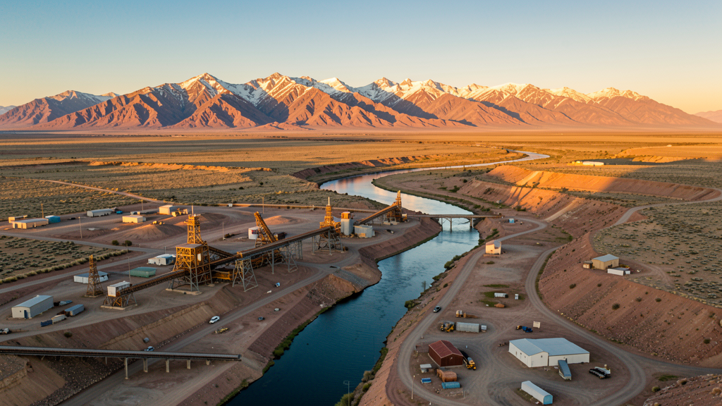
Get Matched With a Local Surveyor
Drone Survey Services Available in Elko, NV
Elko is the hub of northeastern Nevada gold mining country. Newmont and Barrick Gold operations drive construction, with mining infrastructure inspection and volumetric stockpile analysis as specialized drone survey services. The remote location and high elevation create unique operational challenges.
Drone Surveys for Elko's Construction Market
Elko is the hub of northeastern Nevada gold mining country. Construction is driven by mining infrastructure, including Newmont and Barrick Gold operations, mining camp expansion, and residential development to support the mining workforce. The Elko General Hospital expansion and Elko County school construction provide institutional demand. The city serves as a regional supply center for the mining industry.
Active Developers in the Area:
- Newmont Mining — Gold mining infrastructure and processing facility construction
- Barrick Gold — Mining operations and workforce housing expansion
- Elko County School District — School construction and facility upgrades

Typical Project Costs in Nevada
Cost ranges are based on market data for Elko Micropolitan Area. Actual pricing depends on site size, complexity, and deliverables.
| Service Type | Low End | High End |
|---|---|---|
| Topographic Survey | $1,200 | $6,000 |
| Drone Inspection | $450 | $2,500 |
| LiDAR Scanning | $2,000 | $10,000 |
| Environmental Monitoring | $1,000 | $5,000 |
| Aerial Imagery | $250 | $1,500 |
| Construction Monitoring | $550 | $2,800 |
| Real Estate Photography | $200 | $1,000 |
| Roof Inspection | $250 | $1,200 |
Local Airspace & Regulations in Elko, NV
FAA Part 107 Requirements
All commercial drone operations in Nevada require the pilot to hold an active FAA Part 107 Remote Pilot Certificate. Our network surveyors are verified Part 107 holders.
State Drone Laws
Nevada enacted AB 269 (2015), establishing the Governor Office of Economic Development UAS program and preempting local municipalities from regulating drone flight paths, airspace, or pilot licensing. SB 92 (2017) added privacy protections prohibiting drone surveillance of private property without consent and restricting weaponization. AB 487 (2019) further clarified that only the state may regulate UAS operations, preventing cities and counties from enacting their own drone flight restrictions. Nevada hosts major restricted military airspace including Nellis Air Force Base, Creech Air Force Base (home to MQ-1 Predator and MQ-9 Reaper operations), Naval Air Station Fallon, and the Nevada Test and Training Range — one of the largest restricted airspace complexes in the continental US. Commercial operators must hold a valid FAA Part 107 Remote Pilot Certificate. The state does not require a separate state drone license. Operators flying near military installations, the Nevada National Security Site, or tribal lands must coordinate with the controlling agency. Nevada desert terrain and extreme summer temperatures (frequently above 110 degrees in southern NV) significantly affect drone battery life and motor performance.
Local Ordinances
Elko follows FAA Part 107 regulations. Under Nevada state law (AB 487, 2019), local municipalities cannot regulate drone flight paths. The Ruby Mountains and Humboldt National Forest to the south require US Forest Service permits for commercial flights. Mining operations in the area may have private restrictions near their facilities.
Restricted Airspace
- Class D airspace around Elko Regional Airport (EKO)
- Open high desert and mining terrain with minimal restrictions beyond airport
- Ruby Mountains and Humboldt National Forest flight restrictions to the south
Airports in the area: Elko Regional Airport (EKO)
Why Hire Through Aerius View in Elko, NV?
FAA-Certified
Every surveyor holds an active Part 107 Remote Pilot Certificate.
Local to Elko
Surveyors who know the Nevada airspace and local permitting.
No Cost to Quote
Submit your project at no charge. Pay the surveyor directly if you proceed.
Fast Turnaround
A local surveyor contacts you within 2 business days.
How Our Elko Matching Process Works
We're actively building our network of FAA-certified drone operators in Elko, NV. Here's exactly what happens when you submit a project request.
Submit Your Project
Tell us your site location, acreage, and what you need (topographic survey, LiDAR, inspection, etc.). Takes 60 seconds. No cost, no obligation.
We Match & Vet
We identify Part 107-certified operators in Nevada with the right equipment for your project. Every pilot is verified for active certification, insurance, and relevant experience in Nevada airspace.
You Get Quotes
Matched surveyors contact you within 2 business days with quotes. You compare pricing, timelines, and deliverables, then choose the right fit. You pay the surveyor directly, no markup.
What Deliverables Do You Get?
Every project includes professional-grade deliverables compatible with standard construction and engineering software:
- Orthomosaic maps (GeoTIFF) for site overview and documentation
- Point clouds (LAS/LAZ) for 3D modeling and volumetric analysis
- DEM/DSM terrain models for cut/fill and grade analysis
- Contour lines (DXF/DWG, CAD-ready) for Civil 3D and Revit
- Progress reports with side-by-side comparisons for construction monitoring
- Coordinate systems matched to your project datum (State Plane, UTM, or local)
Insurance & Liability Protection
Pilot Insurance Required
Every operator in our network must carry active liability insurance. Minimum coverage: $1,000,000 general liability. Proof of insurance is verified before any pilot joins the network.
FAA Part 107 Verified
We confirm each pilot's Remote Pilot Certificate is active and in good standing through the FAA Airmen Inquiry system. Expired certificates are flagged automatically.
Equipment Documentation
Pilots list their drone models, sensors (RGB, LiDAR, thermal, multispectral), and payload specs so we can match the right equipment to your project requirements.
Site Safety Coordination
Pilots coordinate with your site superintendent for safe operations on active construction sites, including flight plans that avoid worker areas and equipment zones.
Elko, NV Drone Survey FAQs
What drone services are most needed in Elko?
Mining infrastructure inspection and construction monitoring are primary needs. Newmont and Barrick Gold operations create demand for facility inspection, tailings impoundment monitoring, and volumetric analysis of ore stockpiles. Residential development for the mining workforce requires topographic surveys. Environmental monitoring of mining impacts is a specialized service area.
Does Elko have controlled airspace?
Elko Regional Airport (EKO) has Class D airspace. Drone operators flying within the Class D radius need LAANC authorization. The airport primarily serves general aviation, regional commercial flights, and mining industry charter traffic.
Can I fly a drone near gold mining operations in Elko?
Gold mining operations are private industrial property with safety and security considerations. Newmont and Barrick Gold facilities may have restrictions on drone overflights. Coordinate with mine management before any flights near processing plants, tailings impoundments, and open pit operations. Some mining companies use their own drone programs for site survey work.
Can I fly a drone in the Ruby Mountains near Elko?
The Ruby Mountains and Humboldt National Forest south of Elko are managed by the US Forest Service. Commercial drone flights require a special use permit. The Ruby Mountains are known for heli-skiing and remote wilderness, creating challenging but scenic aerial survey conditions.
How does Elko elevation affect drone flying?
Elko sits at approximately 5,100 feet elevation in the Humboldt River valley. The high elevation reduces drone performance significantly. Winter temperatures well below freezing further reduce battery life. Summer temperatures can still reach 90 degrees. The Ruby Mountains to the south create variable wind conditions. Plan for short flight times year-round.
What makes Elko unique for drone survey?
Elko is the hub of one of the worlds most productive gold mining regions. Mining inspection, tailings monitoring, and volumetric stockpile analysis are specialized and high-demand services. The remote location means fewer competing drone operators, creating opportunity for survey companies willing to serve the area. Winter operations require cold-weather drone preparation.
Nearby Cities
Are You a Drone Surveyor in Elko?
Get pre-qualified leads in your service area. No membership fees, no monthly minimums. First lead free.
Ready to Start Your Project in Elko, NV?
Get matched with a local, FAA-certified surveyor. No cost, no obligation.
Request a Free Quote