Drone Survey Services in Eagle, ID
Eagle luxury home market and the 1,800+ acre Avimor master-planned community expansion into the foothills are driving premium demand for high-resolution aerial imagery and LiDAR surveys along the State Street corridor in this affluent Boise suburb.
Serving Ada County & the Boise City area
Request a Free Quote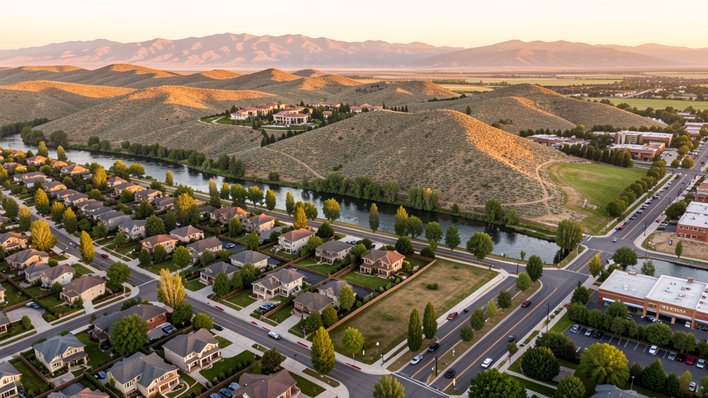
Get Matched With a Local Surveyor
Drone Survey Services Available in Eagle, ID
Eagle is an affluent suburb northwest of Boise with median household incomes well above the Ada County average. The city growth is concentrated in master-planned communities extending into the foothills, with commercial development along State Street (Highway 44). The Boise metro overall population growth is pushing development northward from Eagle, creating sustained demand for survey and mapping services. Eagle proximity to BOI Class C airspace means most drone operations require FAA LAANC authorization.
Drone Surveys for Eagle's Construction Market
Eagle is known for affluent master-planned communities, with the Avimor development (1,800+ acres) continuing northward expansion into the foothills. The City of Eagle approved approximately 650 building permits in 2023, with significant commercial growth along State Street (Highway 44). The Eagle Road corridor widening project ($12M ACHD-funded) is underway. Luxury home construction and the Eagle Island Crossing mixed-use development drive demand for high-resolution aerial imagery and site surveys.
Active Developers in the Area:

Typical Project Costs in Idaho
Cost ranges are based on market data for Boise City. Actual pricing depends on site size, complexity, and deliverables.
| Service Type | Low End | High End |
|---|---|---|
| Topographic Survey | $1,600 | $4,800 |
| Drone Inspection | $1,000 | $3,400 |
| LiDAR Scanning | $2,800 | $8,200 |
| Environmental Monitoring | $1,400 | $5,000 |
| Aerial Imagery | $450 | $1,700 |
| Construction Monitoring | $1,100 | $4,200 |
| Real Estate Photography | $350 | $1,400 |
| Roof Inspection | $300 | $1,100 |
Local Airspace & Regulations in Eagle, ID
FAA Part 107 Requirements
All commercial drone operations in Idaho require the pilot to hold an active FAA Part 107 Remote Pilot Certificate. Our network surveyors are verified Part 107 holders.
State Drone Laws
Idaho Code § 21-801 et seq (Title 21, Chapter 8) governs unmanned aircraft systems statewide. The law prohibits drone surveillance of private property without consent (§ 21-803, $500 civil penalty per violation), bans weaponization of drones (§ 21-804, misdemeanor), and prohibits using drones to interfere with wildfire suppression (§ 21-805). The state preempts local regulation of drone flight paths and airspace (§ 21-810), though cities may regulate takeoff and landing on public property they own. Idaho does not require a separate state-level drone license. Commercial drone operators must hold a valid FAA Part 107 Remote Pilot Certificate. Idaho was one of the first states to pass comprehensive drone legislation in 2013 (HB 279), amended by SB 1133 (2021) to align definitions with the federal Part 107 framework.
Local Ordinances
Eagle does not have a dedicated drone ordinance, consistent with Idaho state preemption (section 21-810). Eagle Parks and Recreation requires a special use permit for drone flights in city parks including Eagle Island State Park and Reed Nolan Park. Flights near Eagle High School and Heritage Elementary should be coordinated with West Ada School District. The city noise ordinance (Title 6) applies to motorized equipment including drones during early morning (before 7 AM) or late evening (after 9 PM) near residences.
Restricted Airspace
- BOI Class C airspace outer ring covers Eagle. LAANC authorization required for commercial drone flights within controlled airspace.
- Mountain Home AFB MOA and Restricted Area R-4302, 35 miles southeast. Military training routes VR-178 and VR-180 pass through foothills north of Eagle. Check NOTAMs.
- Eagle Island State Park managed by Idaho State Parks. Unauthorized drone operations prohibited without a special use permit from Idaho Department of Parks and Recreation.
- Boise National Forest boundary begins north of Eagle foothills developments. Seasonal TFRs during wildfire season (June through October). Check NOTAMs before operating.
- Eagle lies under approach corridor for BOI Runway 10R-28L. Altitude restrictions via FAA UAS Facility Maps for the Hill Road corridor.
- Eagle Parks and Recreation requires a special use permit for drone flights in city parks including Eagle Island State Park and Reed Nolan Park.
Airports in the area: undefined (undefined), undefined (undefined), undefined (undefined), undefined (undefined)
Why Hire Through Aerius View in Eagle, ID?
FAA-Certified
Every surveyor holds an active Part 107 Remote Pilot Certificate.
Local to Eagle
Surveyors who know the Idaho airspace and local permitting.
No Cost to Quote
Submit your project at no charge. Pay the surveyor directly if you proceed.
Fast Turnaround
A local surveyor contacts you within 2 business days.
How Our Eagle Matching Process Works
We're actively building our network of FAA-certified drone operators in Eagle, ID. Here's exactly what happens when you submit a project request.
Submit Your Project
Tell us your site location, acreage, and what you need (topographic survey, LiDAR, inspection, etc.). Takes 60 seconds. No cost, no obligation.
We Match & Vet
We identify Part 107-certified operators in Idaho with the right equipment for your project. Every pilot is verified for active certification, insurance, and relevant experience in Idaho airspace.
You Get Quotes
Matched surveyors contact you within 2 business days with quotes. You compare pricing, timelines, and deliverables, then choose the right fit. You pay the surveyor directly, no markup.
What Deliverables Do You Get?
Every project includes professional-grade deliverables compatible with standard construction and engineering software:
- Orthomosaic maps (GeoTIFF) for site overview and documentation
- Point clouds (LAS/LAZ) for 3D modeling and volumetric analysis
- DEM/DSM terrain models for cut/fill and grade analysis
- Contour lines (DXF/DWG, CAD-ready) for Civil 3D and Revit
- Progress reports with side-by-side comparisons for construction monitoring
- Coordinate systems matched to your project datum (State Plane, UTM, or local)
Insurance & Liability Protection
Pilot Insurance Required
Every operator in our network must carry active liability insurance. Minimum coverage: $1,000,000 general liability. Proof of insurance is verified before any pilot joins the network.
FAA Part 107 Verified
We confirm each pilot's Remote Pilot Certificate is active and in good standing through the FAA Airmen Inquiry system. Expired certificates are flagged automatically.
Equipment Documentation
Pilots list their drone models, sensors (RGB, LiDAR, thermal, multispectral), and payload specs so we can match the right equipment to your project requirements.
Site Safety Coordination
Pilots coordinate with your site superintendent for safe operations on active construction sites, including flight plans that avoid worker areas and equipment zones.
Eagle, ID Drone Survey FAQs
Can I fly a drone over Eagle Island State Park?
Idaho State Parks prohibits unauthorized drone operations within Eagle Island State Park. You must obtain a special use permit from Idaho Parks and Recreation before flying. The park also lies within the BOI Class C airspace outer area, so LAANC authorization is additionally required for Part 107 flights.
Do I need LAANC authorization to fly a drone in Eagle?
Yes. Eagle falls within the Class C airspace surrounding Boise Air Terminal (BOI). LAANC authorization is required for most commercial flights, particularly above 100 ft AGL in the area.
What development projects are creating demand for drone surveys in Eagle?
The Avimor master-planned community expansion (1,800+ acres), Eagle Road corridor widening ($12M ACHD project), and Eagle Island Crossing mixed-use development are driving survey demand in Eagle.
Are there special restrictions for flying drones in the foothills north of Eagle?
The Boise National Forest boundary begins north of Eagle foothills developments. Seasonal TFRs during wildfire season (June through October) may restrict flights. Check NOTAMs before operating in the foothills area.
How much does a LiDAR survey cost in Eagle?
LiDAR surveys in Eagle typically range from $2,800 to $8,200 depending on acreage and density of vegetation, with a 7-12 day turnaround. The affluent market and luxury home construction may trend toward the higher end for residential and construction monitoring services.
Nearby Cities
Are You a Drone Surveyor in Eagle?
Get pre-qualified leads in your service area. No membership fees, no monthly minimums. First lead free.
Ready to Start Your Project in Eagle, ID?
Get matched with a local, FAA-certified surveyor. No cost, no obligation.
Request a Free Quote