Drone Survey Services in Burley, ID
As a regional agricultural processing hub home to McCain Foods and Lamb Weston, Burley has steady construction activity including residential development on the east side and ongoing facility maintenance at processing plants, creating consistent demand for drone inspection and survey services along the Snake River corridor.
Serving Cassia County & the Twin Falls area
Request a Free Quote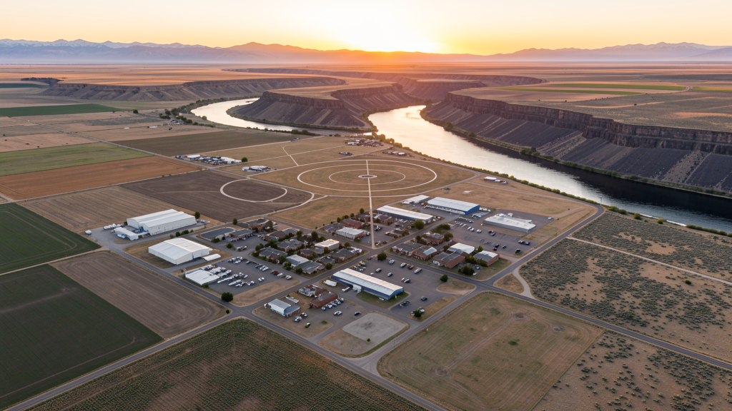
Get Matched With a Local Surveyor
Drone Survey Services Available in Burley, ID
Burley sits along the Snake River in Cassia County, serving as the county seat and a major agricultural processing center for the Magic Valley. The city is anchored by food processing plants operated by McCain Foods and Lamb Weston, which drive consistent facility maintenance and expansion construction. The surrounding agricultural lands create seasonal airspace coordination needs with crop duster operations. The Snake River Canyon to the south provides unique terrain for drone survey work but requires careful wind planning near canyon edges.
Drone Surveys for Burley's Construction Market
Burley serves as the Cassia County seat and a regional agricultural processing hub, home to McCain Foods and Lamb Weston processing plants. Construction activity includes residential development on the east side, commercial expansion along Overland Avenue, and infrastructure improvements to the Snake River irrigation system. The Idaho Transportation Department is upgrading Highway 30 through the city. While not a boom market, steady agricultural construction and food processing facility expansion create consistent demand for inspection and survey services.
Active Developers in the Area:

Typical Project Costs in Idaho
Cost ranges are based on market data for Twin Falls. Actual pricing depends on site size, complexity, and deliverables.
| Service Type | Low End | High End |
|---|---|---|
| Topographic Survey | $850 | $3,200 |
| Drone Inspection | $550 | $2,100 |
| LiDAR Scanning | $2,100 | $5,800 |
| Environmental Monitoring | $1,050 | $3,800 |
| Aerial Imagery | $330 | $1,200 |
| Construction Monitoring | $700 | $2,600 |
| Real Estate Photography | $200 | $800 |
| Roof Inspection | $250 | $900 |
Local Airspace & Regulations in Burley, ID
FAA Part 107 Requirements
All commercial drone operations in Idaho require the pilot to hold an active FAA Part 107 Remote Pilot Certificate. Our network surveyors are verified Part 107 holders.
State Drone Laws
Idaho Code § 21-801 et seq (Title 21, Chapter 8) governs unmanned aircraft systems statewide. The law prohibits drone surveillance of private property without consent (§ 21-803, $500 civil penalty per violation), bans weaponization of drones (§ 21-804, misdemeanor), and prohibits using drones to interfere with wildfire suppression (§ 21-805). The state preempts local regulation of drone flight paths and airspace (§ 21-810), though cities may regulate takeoff and landing on public property they own. Idaho does not require a separate state-level drone license. Commercial drone operators must hold a valid FAA Part 107 Remote Pilot Certificate. Idaho was one of the first states to pass comprehensive drone legislation in 2013 (HB 279), amended by SB 1133 (2021) to align definitions with the federal Part 107 framework.
Local Ordinances
Burley does not have a formal drone permitting ordinance. Cassia County requests notification for commercial drone operations on county-owned property. Idaho Code section 21-810 preempts local regulation of drone airspace or flight paths. Flights from private property require owner permission and FAA Part 107 compliance. Agricultural operations around Burley require coordination with crop duster operators during spraying season (April through September). Ag processing facilities like McCain Foods and Lamb Weston may have facility-specific security restrictions.
Restricted Airspace
- Burley is in uncontrolled Class G airspace. No LAANC authorization required for commercial drone flights in the immediate Burley area. However, flights west toward Twin Falls may enter TWF Class D airspace requiring LAANC.
- Minidoka County airbase and Idaho National Guard training areas are 20 miles east. Military training routes (MTRs) may affect operations at higher altitudes. Check FAA charts for IR/VR route segments.
- Snake River Canyon creates terrain considerations for drone flights near the canyon rim. Wind patterns and turbulence can be significant near canyon edges, especially in afternoon hours.
- Burley City Code does not have specific drone ordinances. Cassia County requires notification for commercial operations on county property. Idaho Code section 21-810 preempts local airspace regulation.
- Agricultural operations dominate the surrounding area. Commercial drone flights over active farmland should coordinate with aerial applicators during crop spraying season (April through September). Ag processing facilities may have facility-specific restrictions.
Airports in the area: undefined (undefined), undefined (undefined), undefined (undefined)
Why Hire Through Aerius View in Burley, ID?
FAA-Certified
Every surveyor holds an active Part 107 Remote Pilot Certificate.
Local to Burley
Surveyors who know the Idaho airspace and local permitting.
No Cost to Quote
Submit your project at no charge. Pay the surveyor directly if you proceed.
Fast Turnaround
A local surveyor contacts you within 2 business days.
How Our Burley Matching Process Works
We're actively building our network of FAA-certified drone operators in Burley, ID. Here's exactly what happens when you submit a project request.
Submit Your Project
Tell us your site location, acreage, and what you need (topographic survey, LiDAR, inspection, etc.). Takes 60 seconds. No cost, no obligation.
We Match & Vet
We identify Part 107-certified operators in Idaho with the right equipment for your project. Every pilot is verified for active certification, insurance, and relevant experience in Idaho airspace.
You Get Quotes
Matched surveyors contact you within 2 business days with quotes. You compare pricing, timelines, and deliverables, then choose the right fit. You pay the surveyor directly, no markup.
What Deliverables Do You Get?
Every project includes professional-grade deliverables compatible with standard construction and engineering software:
- Orthomosaic maps (GeoTIFF) for site overview and documentation
- Point clouds (LAS/LAZ) for 3D modeling and volumetric analysis
- DEM/DSM terrain models for cut/fill and grade analysis
- Contour lines (DXF/DWG, CAD-ready) for Civil 3D and Revit
- Progress reports with side-by-side comparisons for construction monitoring
- Coordinate systems matched to your project datum (State Plane, UTM, or local)
Insurance & Liability Protection
Pilot Insurance Required
Every operator in our network must carry active liability insurance. Minimum coverage: $1,000,000 general liability. Proof of insurance is verified before any pilot joins the network.
FAA Part 107 Verified
We confirm each pilot's Remote Pilot Certificate is active and in good standing through the FAA Airmen Inquiry system. Expired certificates are flagged automatically.
Equipment Documentation
Pilots list their drone models, sensors (RGB, LiDAR, thermal, multispectral), and payload specs so we can match the right equipment to your project requirements.
Site Safety Coordination
Pilots coordinate with your site superintendent for safe operations on active construction sites, including flight plans that avoid worker areas and equipment zones.
Burley, ID Drone Survey FAQs
Do I need LAANC authorization to fly a drone in Burley?
Most of Burley is in uncontrolled Class G airspace and does not require LAANC. Flights west toward Twin Falls may enter TWF Class D airspace requiring authorization. Check the FAA UAS Facility Map for your specific flight area.
Are there agricultural drone restrictions around Burley?
Burley is surrounded by active farmland with crop duster operations from April through September. Coordinate with local aerial applicators before flying over agricultural areas. Ag processing facilities like McCain Foods and Lamb Weston may have facility-specific security restrictions.
What airspace considerations affect flights near the Snake River Canyon?
The Snake River Canyon creates terrain-induced wind patterns and turbulence, especially near the canyon rim in afternoon hours. Drone operators should be cautious of sudden wind shifts and updrafts along canyon edges. Maintain visual line of sight and plan for wind when flying near canyon areas.
What construction activity is happening in Burley?
Burley has steady construction activity including residential development on the east side, commercial expansion along Overland Avenue, and ongoing maintenance and expansion at the McCain Foods and Lamb Weston processing plants. The ITD Highway 30 upgrade is the largest infrastructure project.
How much does a drone survey cost in the Burley area?
Topographic surveys in Burley range from $850 to $3,200. LiDAR scanning costs $2,100 to $5,800. Construction monitoring runs $700 to $2,600. Pricing reflects the smaller market and lower operating costs compared to Boise or Coeur dAlene.
Nearby Cities
Are You a Drone Surveyor in Burley?
Get pre-qualified leads in your service area. No membership fees, no monthly minimums. First lead free.
Ready to Start Your Project in Burley, ID?
Get matched with a local, FAA-certified surveyor. No cost, no obligation.
Request a Free Quote