Drone Survey Services in Bisbee, AZ
From historic building restoration and adaptive reuse to tourism infrastructure and hillside residential surveys, Bisbee is a steep-canyon mining town turned arts community where historic district constraints and the US-Mexico border zone shape every survey mission.
Serving Cochise County & the Sierra Vista area
Request a Free Quote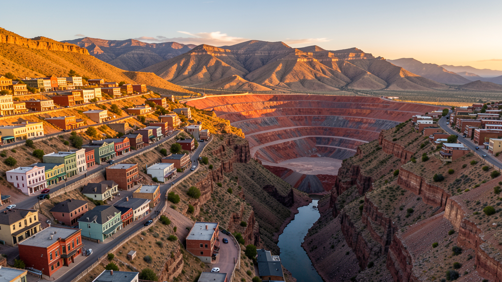
Get Matched With a Local Surveyor
Drone Survey Services Available in Bisbee, AZ
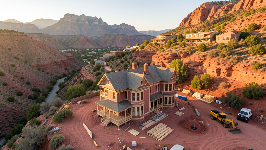
Bisbee is a historic mining town focused on arts and tourism. Construction is specialized, centered on historic restoration and adaptive reuse. The historic district requires careful survey work. Steep canyon terrain creates challenging wind patterns. The proximity to the US-Mexico border requires awareness of CBP operations.
Drone Surveys for Bisbee's Construction Market
Bisbee is a historic mining town turned arts and tourism community. Construction is limited but specialized, focused on historic building restoration, adaptive reuse projects, and tourism infrastructure. The city historic district designation requires careful survey work for any renovation or new construction. The Queen Mine Tour and tourism infrastructure generate periodic construction needs. Cochise County has invested in road improvements along Highway 80 connecting Bisbee to Sierra Vista. Residential development is limited due to terrain and historic district constraints but creates niche demand for topographic surveys of challenging hillside lots. The nearby copper mining heritage sites may require environmental monitoring surveys.
Active Developers in the Area:
Typical Project Costs in Arizona
Cost ranges are based on market data for Sierra Vista. Actual pricing depends on site size, complexity, and deliverables.
| Service Type | Low End | High End |
|---|---|---|
| Topographic Survey | $1,800 | $4,500 |
| Drone Inspection | $250 | $850 |
| LiDAR Scanning | $2,800 | $8,500 |
| Environmental Monitoring | $800 | $3,200 |
| Aerial Imagery | $175 | $500 |
| Construction Monitoring | $1,200 | $3,200 |
| Real Estate Photography | $175 | $450 |
| Roof Inspection | $225 | $800 |
Local Airspace & Regulations in Bisbee, AZ
FAA Part 107 Requirements
All commercial drone operations in Arizona require the pilot to hold an active FAA Part 107 Remote Pilot Certificate. Our network surveyors are verified Part 107 holders.
State Drone Laws
Arizona SB 1449 (2016) was the first state law regulating drone use, prohibiting drone operations that interfere with law enforcement, emergency responders, or wildfire suppression efforts. The law prohibits drone flights within 3 miles of a wildfire or prescribed burn and makes violation a class 1 misdemeanor. ARS Title 13 Chapter 29 Article 3 restricts drone surveillance of private property and weaponization of drones. Commercial operators must hold a valid FAA Part 107 Remote Pilot Certificate. Arizona does not require a separate state drone license, but operators must comply with FAA Part 107 rules and any local ordinances. The Arizona Department of Public Safety maintains guidelines for drone operations near critical infrastructure including power plants, dams, and military installations.
Local Ordinances
Bisbee follows Cochise County regulations for drone operations. Commercial operators must hold FAA Part 107 certification. The city does not have a specific drone ordinance but the historic district designation means any construction-related drone survey work should coordinate with the Bisbee Historic Preservation Office. Flights over the Bisbee Mining and Historical Museum and the Queen Mine Tour area should be coordinated with tour operators. The city unique geography, built into steep canyon walls, creates natural constraints on drone operations. The proximity to the US-Mexico border requires awareness of CBP air operations.
Restricted Airspace
- Bisbee is outside Class D airspace but is near Fort Huachuca restricted military airspace to the north. Drone operators should verify boundaries before flying north of Bisbee.
- Coronado National Forest surrounds Bisbee. The Mule Mountains area includes designated wilderness areas where drone flights are prohibited by the US Forest Service.
- Historic mine shafts and tailings areas create safety hazards for drone operations. Operators should research known hazards before flying near old mining areas.
- US-Mexico border zone: Bisbee is approximately 10 miles from the US-Mexico border. Customs and Border Protection operates in this area. Drone operators should be aware of CBP air operations and potential temporary flight restrictions.
- Steep terrain and narrow canyons: Bisbee is built in a canyon with steep terrain creating challenging wind patterns and limited landing zones. Pre-programmed waypoint missions are recommended.
Airports in the area: undefined (undefined), undefined (undefined)
Why Hire Through Aerius View in Bisbee, AZ?
FAA-Certified
Every surveyor holds an active Part 107 Remote Pilot Certificate.
Local to Bisbee
Surveyors who know the Arizona airspace and local permitting.
No Cost to Quote
Submit your project at no charge. Pay the surveyor directly if you proceed.
Fast Turnaround
A local surveyor contacts you within 2 business days.
How Our Bisbee Matching Process Works
We're actively building our network of FAA-certified drone operators in Bisbee, AZ. Here's exactly what happens when you submit a project request.
Submit Your Project
Tell us your site location, acreage, and what you need (topographic survey, LiDAR, inspection, etc.). Takes 60 seconds. No cost, no obligation.
We Match & Vet
We identify Part 107-certified operators in Arizona with the right equipment for your project. Every pilot is verified for active certification, insurance, and relevant experience in Arizona airspace.
You Get Quotes
Matched surveyors contact you within 2 business days with quotes. You compare pricing, timelines, and deliverables, then choose the right fit. You pay the surveyor directly, no markup.
What Deliverables Do You Get?
Every project includes professional-grade deliverables compatible with standard construction and engineering software:
- Orthomosaic maps (GeoTIFF) for site overview and documentation
- Point clouds (LAS/LAZ) for 3D modeling and volumetric analysis
- DEM/DSM terrain models for cut/fill and grade analysis
- Contour lines (DXF/DWG, CAD-ready) for Civil 3D and Revit
- Progress reports with side-by-side comparisons for construction monitoring
- Coordinate systems matched to your project datum (State Plane, UTM, or local)
Insurance & Liability Protection
Pilot Insurance Required
Every operator in our network must carry active liability insurance. Minimum coverage: $1,000,000 general liability. Proof of insurance is verified before any pilot joins the network.
FAA Part 107 Verified
We confirm each pilot's Remote Pilot Certificate is active and in good standing through the FAA Airmen Inquiry system. Expired certificates are flagged automatically.
Equipment Documentation
Pilots list their drone models, sensors (RGB, LiDAR, thermal, multispectral), and payload specs so we can match the right equipment to your project requirements.
Site Safety Coordination
Pilots coordinate with your site superintendent for safe operations on active construction sites, including flight plans that avoid worker areas and equipment zones.
Bisbee, AZ Drone Survey FAQs
Do I need a permit for a drone survey in Bisbee?
Bisbee follows Cochise County regulations. You need a permit only for flights on public property. Surveys from private property with owner permission do not require a city permit. All commercial operations require FAA Part 107 certification. The historic district may require additional coordination for construction-related survey work.
Can I fly drones near the historic mining areas?
Historic mine shafts and tailings areas create safety hazards for drone operations. Research known hazards before flying near old mining areas. The Queen Mine Tour area should be coordinated with tour operators. The city is built into steep canyon walls, creating challenging wind patterns and limited landing zones.
Are there border zone restrictions near Bisbee?
Bisbee is approximately 10 miles from the US-Mexico border. Customs and Border Protection operates in this area. Drone operators should be aware of CBP air operations and potential temporary flight restrictions. Always check NOTAMs before flying near the border zone.
What are the main survey needs in Bisbee?
Historic building restoration, adaptive reuse projects, and tourism infrastructure are the primary needs. The historic district designation requires careful survey work for renovations. Hillside residential lots create niche demand for topographic surveys. Road improvements along Highway 80 also generate survey work.
How much does a drone survey cost in Bisbee?
Topographic surveys range from $1,800 to $4,500, potentially higher for steep terrain lots. Roof inspections run $225-$800. Real estate drone photography starts at $175. Historic building documentation surveys may have specialized requirements. The challenging terrain increases operational complexity.
Nearby Cities
Are You a Drone Surveyor in Bisbee?
Get pre-qualified leads in your service area. No membership fees, no monthly minimums. First lead free.
Ready to Start Your Project in Bisbee, AZ?
Get matched with a local, FAA-certified surveyor. No cost, no obligation.
Request a Free Quote